Orbit Types – Science & Technology Notes
When a satellite or spacecraft is launched, it is usually placed in one of several orbits around Earth - or it may be sent on an interplanetary journey, which means it does not orbit Earth anymore, but instead orbits the Sun until it arrives at its final destination, such as Mars or Jupiter. Many factors influence which orbit is best for a satellite to use, depending on what the satellite is designed to accomplish. In this article, we will discuss in detail regarding Orbit Types which will be helpful for UPSC exam preparation.
Table of Contents
Orbit – Background
- During the early stages of our Solar System's formation, dust, gas, and ice moved through space with great speed and momentum, forming a cloud around the Sun.
- Because the Sun is so much larger than these small bits of dust and gas, its gravity drew them into orbit around it, forming a ring around the Sun.
- These particles eventually settled and clumped together, growing larger and larger like rolling snowballs until they formed what we now call planets, moons, and asteroids.
- Because the planets were all formed together in this manner, they all orbit the Sun in the same direction and in roughly the same plane.
What is an Orbit?
- An orbit is the curved path that an object in space (such as a star, planet, moon, asteroid, or spacecraft) takes due to gravity around another object.
- Gravity attracts objects in space that have mass to other nearby objects. If they are drawn together with enough force, they can sometimes begin to orbit each other.
- Objects of similar mass orbit each other, with neither at the centre, whereas small objects orbit larger objects. The Moon orbits the Earth and the Earth orbits the Sun in our Solar System, but that does not mean the larger object remains motionless.
- Because of gravity, the Moon pulls Earth slightly away from its centre (which is why tides form in our oceans), and our Sun is pulled away from its centre by Earth and other planets.
- Our satellites are launched into orbit in space by rockets. Gravity keeps the satellite in its required orbit, just as gravity keeps the Moon in orbit around Earth.
- A satellite is placed hundreds or thousands of kilometres above the Earth's surface (as if in a very tall tower) and then given a 'push' by the rocket's engines to begin its orbit.
Classification of Orbits by Altitude
The orbits of satellites are classified as High Earth orbit, Medium Earth orbit, and Low Earth orbit based on their height above the earth.
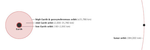
Classification of Orbits by Altitude
High Earth Orbit
- About one-tenth of the way to the moon, high Earth orbit begins. Many weather satellites and some communications satellites have a high Earth orbit, farthest away from the surface.
- When a satellite reaches 42,164 kilometres from the Earth's centre (about 36,000 kilometres from the surface), it enters a "sweet spot" in which its orbit matches the rotation of the Earth.
- Because the satellite orbits at the same speed as the Earth, it appears to stay over a single longitude, though it may drift north to south. This high Earth orbit is known as geosynchronous.
- A satellite in a circular geosynchronous orbit directly over the equator (eccentricity and inclination at zero) will have a geostationary orbit in which it does not move relative to the ground at all. It always passes directly over the same spot on the Earth's surface.
Medium Earth Orbit
- Medium Earth orbit encompasses a broad range of orbits between LEO and GEO.
- It is similar to LEO in that it does not require specific paths around Earth, and it is used by a wide range of satellites with a wide range of applications.
- Navigation satellites, which are designed to monitor a specific region, are among the satellites that orbit in a medium (mid) Earth orbit.
- The semi-synchronous orbit and the Molniya orbit are two notable medium Earth orbits.
- The semi-synchronous orbit is a near-circular (low eccentricity) orbit 26,560 kilometres from the Earth's centre (about 20,200 kilometres above the surface).
- An orbit of a satellite at this altitude takes 12 hours. The Earth rotates beneath the satellite as it moves.
- Every day, the satellite crosses the equator at the same two points. This orbit is reliable and predictable.
- The Global Positioning System (GPS) satellites use this orbit.
- The Molniya orbit is the second most common medium Earth orbit. The Molniya orbit, invented by the Russians, is useful for observing high latitudes.
- The constant view provided by a geostationary orbit is valuable, but because geostationary satellites are parked over the equator, they don't work well for far northern or southern locations, which are always on the edge of view for a geostationary satellite. The Molniya orbit is a viable alternative.
- The orbit of the Molniya satellite is highly eccentric: it moves in an extreme ellipse with the Earth close to one edge.
- The satellite moves very quickly when it is close to the Earth because it is accelerated by our planet's gravity.
- Its speed slows as it moves away, so it spends more time at the top of its orbit, farthest from the Earth.
Low Earth Orbit
- A low Earth orbit (LEO) is, as the name implies, an orbit that is close to the Earth's surface.
- It is normally less than 1000 km above Earth, but it can be as low as 160 km above Earth, which is low in comparison to other orbits but still very far above the Earth's surface.
- In comparison, most commercial planes do not fly at altitudes much higher than 14 km, so even the lowest LEO is more than ten times higher.
- Unlike GEO satellites, which must always orbit along the equator, LEO satellites do not always have to follow the same path around the Earth - their plane can be tilted.
- This means that satellites in LEO have more available routes, which is one of the reasons why LEO is such a popular orbit.
- Because of its close proximity to Earth, LEO is useful for a variety of reasons.
- It is the most commonly used orbit for satellite imaging because being close to the surface allows for higher resolution images.
- It is also the orbit used by the International Space Station (ISS), as it allows astronauts to travel a shorter distance to and from it.
- Satellites in this orbit travel at approximately 7.8 km per second; at this speed, a satellite takes approximately 90 minutes to circle Earth, implying that the ISS travels around Earth approximately 16 times per day.
- Individual LEO satellites, on the other hand, are less useful for tasks such as telecommunication because they move so quickly across the sky and thus require a lot of effort to track from ground stations.
- Instead, communications satellites in low-Earth orbit (LEO) frequently operate as part of a large combination, or constellation, of multiple satellites to provide continuous coverage.
- To increase coverage, constellations like this, which consist of several of the same or similar satellites, are sometimes launched together to form a 'net' around Earth. Working together, they can cover large areas of the Earth at the same time.
- The majority of scientific satellites, including NASA's Earth Observing System fleet, operate in low Earth orbit.
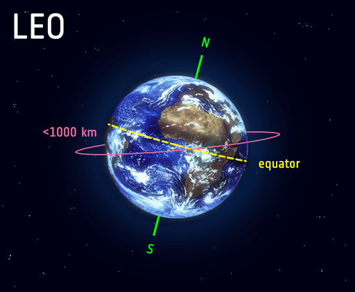
Low Earth Orbit
Factors Affecting Satellite Movement in Orbit
Height
- The distance between the satellite and the Earth's surface, or the height of the orbit, determines how quickly the satellite moves around the Earth.
- The motion of an Earth-orbiting satellite is primarily controlled by Earth's gravity.
- As satellites get closer to Earth, the gravitational pull becomes stronger, and the satellite moves faster.
- NASA's Aqua satellite, for example, takes about 99 minutes to orbit the Earth at about 705 kilometres above the surface, whereas a weather satellite about 36,000 kilometres above the surface takes 23 hours, 56 minutes, and 4 seconds.
- The Moon completes a single orbit in 28 days at 384,403 kilometres from the centre of the Earth.
- Changing the height of a satellite affects its orbital speed. This creates an odd paradox.
- If a satellite operator wants to increase the orbital speed of the satellite, he cannot simply fire the thrusters. This would boost the orbit (increase the altitude), slowing the orbital speed.
- Instead, he must fire the thrusters in the opposite direction of the satellite's forward motion, which would slow a moving vehicle on the ground. This modification will lower the satellite's orbit, increasing its forward velocity.
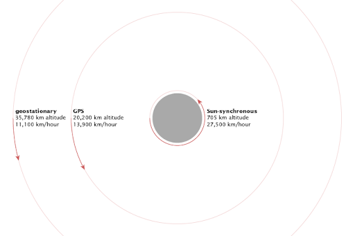
Higher a satellite’s orbit, the slower it moves
Eccentricity
- The shape of the orbit is referred to as eccentricity. A satellite in a low eccentricity orbit circles the Earth in a near circle.
- An eccentric orbit is elliptical, with the distance between the satellite and Earth varying depending on where it is in its orbit.
- The eccentricity (e) of an orbit denotes the orbit's deviation from a perfect circle.
- The eccentricity of a circular orbit is zero, whereas the eccentricity of a highly eccentric orbit is closer to (but always less than) one.
- An eccentric orbit is one in which a satellite moves around one of the ellipse's focal points rather than the centre.
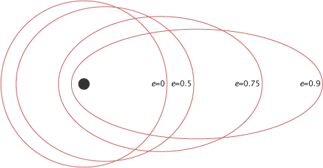
Eccentricity of an orbit
Inclination
- Inclination is the angle of the orbit in relation to the equator of the Earth.
- A satellite with zero inclination orbits directly above the equator.
- The inclination of a satellite orbiting from the north pole (geographic, not magnetic) to the south pole is 90 degrees.
- The angle between the plane of an orbit and the equator is known as orbital inclination.
- A 0° orbital inclination crosses directly above the equator, a 90° orbit crosses directly above the pole, and a 180° orbit crosses directly above the equator in the opposite direction of Earth's spin.
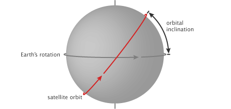
Orbital inclination
Types of Orbits
Many factors influence which orbit is best for a satellite to use, depending on what the satellite is designed to accomplish.
Geostationary Orbit (GEO)
- Satellites in geostationary orbit (GEO) circle Earth above the equator from west to east, taking 23 hours 56 minutes and 4 seconds and travelling at the same rate as Earth.
- Satellites in GEO appear to be 'stationary' over a fixed position as a result of this.
- To perfectly match the rotation of the Earth, GEO satellites should travel at a speed of about 3 km per second at an altitude of 35 786 km. This is much farther away from the Earth's surface than many satellites.
- Satellites that must remain constantly above one location on Earth, such as telecommunication satellites, use GEO. This allows an antenna on Earth to be fixed so that it is always pointed at the satellite.
- Weather monitoring satellites can also use it because they can continuously observe specific areas to see how weather trends emerge there.
- Satellites in GEO cover a large area of the Earth, so as few as three satellites spaced evenly can provide near global coverage. This is because a satellite at this distance from Earth can cover large areas at once.
- To see the entire Earth from GEO, far fewer satellites are required than at a lower altitude.
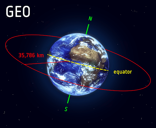
Geostationary Orbit
Polar orbit and Sun-synchronous Orbit (SSO)
- Polar orbit satellites typically travel from north to south rather than west to east, passing roughly over the Earth's poles.
- Polar orbiting satellites do not have to pass exactly through the North and South Poles; a deviation of 20 to 30 degrees is still considered a polar orbit.
- Polar orbits are a type of low Earth orbit because they are at low altitudes ranging from 200 to 1000 kilometres.
- Sun-synchronous orbit (SSO) is a type of polar orbit.
- SSO satellites travelling over the polar regions are synchronised with the Sun.
- This means that they are always in the same 'fixed' position relative to the Sun. This means that the satellite will always visit the same location at the same time.
- This means that the satellite will always observe a point on Earth as if it were constantly at the same time of day, which has a variety of applications; for example, scientists and those who use satellite images can compare how something changes over time.
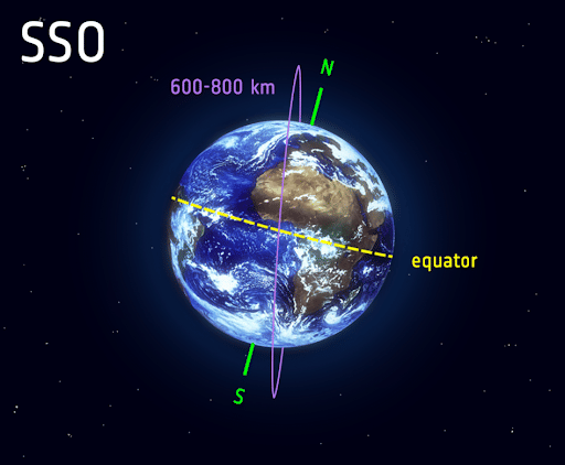
Polar and Sun-synchronous Orbit
Transfer orbits and Geostationary Transfer Orbits (GTO)
- Transfer orbits are a type of orbit that is used to transition from one orbit to another.
- Satellites are not always placed directly on their final orbit when launched from Earth and carried to space by launch vehicles.
- Often, satellites are placed in a transfer orbit, which is an orbit in which the satellite or spacecraft can move from one orbit to another using relatively little energy from built-in motors.
- This allows a satellite to reach a high-altitude orbit, such as GEO, without requiring the launch vehicle to travel all the way to this altitude, which would require more effort - it's like taking a shortcut.
- This method of reaching GEO is an example of one of the most common transfer orbits, known as the geostationary transfer orbit (GTO).
- The eccentricity of an orbit is a measure of how circular (round) or elliptical (squashed) it is.
- The satellite is always the same distance from the Earth's surface in a perfectly round orbit, but in a highly eccentric orbit, the path looks like an ellipse.
- Depending on where the satellite is in its orbit, a highly eccentric orbit like this one can quickly take it from very far away to very close to the Earth's surface.
- In transfer orbits, the payload uses engines to move from one eccentric orbit to another, putting it on track to higher or lower orbits.
- Following liftoff, a launch vehicle travels to space along the path depicted in the figure by the yellow line.
- When the rocket arrives at its destination, it releases the payload, which sends it into an elliptical orbit along the blue line, further away from Earth.
- The apogee is the point on the blue elliptical orbit that is farthest away from Earth, and the perigee is the point that is closest.
- When the payload reaches the apogee at 35,786 km GEO altitude, it fires its engines in such a way that it enters and stays in the circular GEO orbit, as shown by the red line in the diagram.
- The GTO is thus the blue path from the yellow orbit to the red orbit.
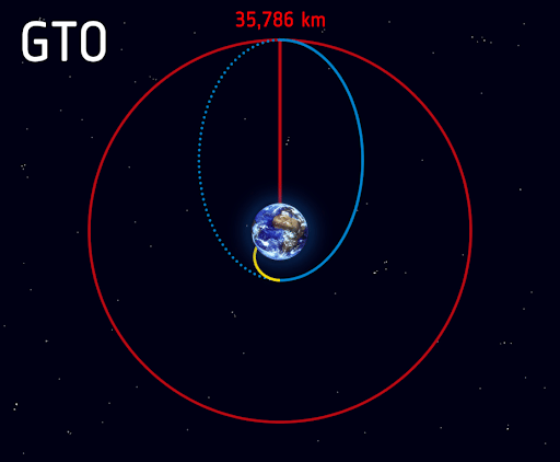
Transfer and Geostationary Transfer Orbits
Lagrange Points (L-points)
- Being too close to Earth can be detrimental to many spacecraft's missions, even at more distant orbits such as GEO.
- For example, for space-based observatories and telescopes whose mission it is to photograph deep, dark space, being close to Earth is extremely detrimental because Earth emits visible and infrared radiation that prevents the telescope from detecting faint lights such as distant galaxies.
- Attempting to photograph dark space with a telescope next to our glowing Earth would be as futile as attempting to photograph stars from Earth in broad daylight.
- Lagrange points, also known as L-points, allow for orbits that are much, much farther away (over a million kilometres) and do not directly orbit Earth.
- These are specific points in space where the gravitational fields of Earth and the Sun interact in such a way that spacecraft orbiting them remain stable and can thus be 'anchored' relative to Earth.
- If a spacecraft were launched to distant points in space, it would naturally fall into an orbit around the Sun, and those spacecrafts would soon end up far from Earth, making communication difficult.
- Instead, spacecraft launched to these special L-points remain fixed and close to Earth with minimal effort without changing orbit.
- L1 and L2 are the most commonly used L-points. Both are four times farther away from Earth than the Moon - 1.5 million km versus GEO's 36,000 km - but that is still only about 1% of Earth's distance from the Sun.
Conclusion
As there is no air in space and thus no air friction, gravity allows the satellite to orbit Earth with little assistance. By putting satellites into orbit, we can use technologies for communication, navigation, weather forecasting, and astronomy observations.
| Other Relevant Links | |
|---|---|
| Science & Technology Policy in India | Scientific Policy Resolution 1958 |
| Science & Technology Policy of 1983 | Science & Technology Policy of 2003 |
| Science, Technology and Innovation Policy 2013 | New Initiatives Aligned with the National Agenda |
| India and World collaboration in science projects | National Intellectual Property Rights Policy |
FAQs
Question: What are the different types of orbits used in satellite communications?
Answer: Satellites use different types of orbits depending on their purpose. The primary types of orbits are:
- Low Earth Orbit (LEO): Satellites in LEO are used for communication, Earth observation, and scientific missions. These orbits are located between 160 km and 2,000 km above Earth.
- Medium Earth Orbit (MEO): Used for navigation satellites like GPS, typically located between 2,000 km and 35,786 km above Earth.
- Geostationary Orbit (GEO): Positioned at 35,786 km above Earth's equator, these satellites remain fixed relative to a point on Earth, ideal for weather forecasting and communication.
- Polar Orbit: These orbits pass over the Earth's poles and are used for Earth observation and mapping.
Question: What is the difference between LEO, MEO, and GEO orbits?
Answer: The key differences between these orbits are their altitudes and uses:
- LEO: Typically 160 km to 2,000 km; used for communication, Earth observation, and space exploration.
- MEO: Typically 2,000 km to 35,786 km; used for navigation and some communication satellites.
- GEO: Around 35,786 km above Earth; satellites in this orbit remain fixed relative to the Earth’s surface, useful for communication and weather monitoring.
Question: Why are satellites in GEO always above the same point on Earth?
Answer: Satellites in GEO orbit are positioned at a distance of 35,786 km above the Earth’s equator. At this altitude, the satellite’s orbital period matches the Earth’s rotation period (24 hours). This synchronization allows the satellite to remain above the same location on Earth at all times, which is ideal for applications such as weather monitoring, communication, and broadcasting.
Question: What is the role of polar orbits in satellite missions?
Answer: Polar orbits pass over the Earth's poles, allowing the satellite to scan the entire surface of the Earth as the planet rotates beneath it. This makes polar orbits ideal for Earth observation, environmental monitoring, and mapping missions, as they provide comprehensive coverage of the Earth's surface over time.
Question: How does altitude affect the functioning of satellites in different orbits?
Answer: The altitude of a satellite directly affects its orbital speed, coverage area, and function:
- LEO: Faster orbital speed, lower coverage area, requires more satellites for global coverage.
- MEO: Slower orbital speed, more coverage area, suitable for navigation satellites.
- GEO: Extremely slow orbital speed, fixed position over the Earth, ideal for communication and weather satellites.
MCQs
1. Which of the following orbits is commonly used for weather monitoring satellites?
A) Low Earth Orbit (LEO)
B) Medium Earth Orbit (MEO)
C) Geostationary Orbit (GEO)
D) Polar Orbit
Answer: (C) See the Explanation
Explanation: Geostationary Orbit (GEO) is commonly used for weather monitoring satellites as they remain stationary relative to a fixed point on Earth, providing continuous coverage of the same area, ideal for monitoring weather patterns.
2. Which orbit is primarily used for Earth observation satellites?
A) Low Earth Orbit (LEO)
B) Medium Earth Orbit (MEO)
C) Geostationary Orbit (GEO)
D) Highly Elliptical Orbit
Answer: (A) See the Explanation
Explanation: Earth observation satellites are typically placed in Low Earth Orbit (LEO) as it provides a closer view of the Earth, allowing higher-resolution imaging for applications like environmental monitoring, weather observation, and military reconnaissance.
3. Which of the following orbits is most suitable for navigation satellites like GPS?
A) Low Earth Orbit (LEO)
B) Medium Earth Orbit (MEO)
C) Geostationary Orbit (GEO)
D) Polar Orbit
Answer: (B) See the Explanation
Explanation: Medium Earth Orbit (MEO) is ideal for navigation satellites like GPS because it provides optimal coverage for global positioning systems, balancing coverage, satellite lifespan, and signal accuracy.
4. What is the main characteristic of a satellite in geostationary orbit?
A) It moves at the same speed as the Earth’s rotation
B) It orbits at a very high altitude
C) It is used for deep space missions
D) It passes over the poles
Answer: (A) See the Explanation
Explanation: A satellite in geostationary orbit moves at the same speed as the Earth’s rotation, allowing it to stay fixed above the same location on Earth, making it ideal for communication and weather monitoring.
5. Which orbit type would be most suitable for a satellite that needs to continuously observe the entire Earth’s surface?
A) Low Earth Orbit (LEO)
B) Medium Earth Orbit (MEO)
C) Polar Orbit
D) Geostationary Orbit (GEO)
Answer: (C) See the Explanation
Explanation: A satellite in a Polar Orbit would pass over both poles, allowing it to observe the entire surface of the Earth over time, as the Earth rotates beneath it. This orbit is ideal for global Earth observation and environmental monitoring.
GS Mains Questions and Model Answers
Q1: Explain the significance of various satellite orbits in global communication and Earth observation systems.
Answer: Satellite orbits play a crucial role in global communication and Earth observation systems. - **Geostationary Orbit (GEO)** allows satellites to remain stationary relative to a fixed point on Earth, providing continuous coverage of a specific area, making it ideal for communication, weather forecasting, and broadcasting services. - **Low Earth Orbit (LEO)** provides higher-resolution images for Earth observation and environmental monitoring, as the satellite is closer to the Earth’s surface. However, it requires a larger number of satellites for global coverage due to its smaller footprint. - **Medium Earth Orbit (MEO)** is mainly used for navigation satellites like GPS, providing wide coverage and ensuring continuous positioning accuracy. Each orbit serves a specific need, enhancing communication networks, weather systems, and navigation technologies.
Q2: Discuss the challenges and benefits of using Low Earth Orbit (LEO) for satellite communication systems.
Answer: The use of Low Earth Orbit (LEO) for satellite communication systems comes with both challenges and benefits. - **Benefits**: - LEO satellites have lower latency compared to GEO satellites, offering faster communication services. - They provide higher-resolution data for Earth observation as they are closer to the Earth’s surface. - LEO networks can be more flexible, supporting various applications such as global internet services and scientific missions. - **Challenges**: - LEO satellites have a limited coverage area, requiring a large constellation of satellites to provide continuous global coverage. - Their shorter lifespan (due to atmospheric drag) necessitates frequent replacements. - They are also more vulnerable to space debris, which can potentially damage the satellites.
Q3: How can the use of satellite orbits contribute to sustainable environmental monitoring and disaster management?
Answer: Satellite orbits play an essential role in environmental monitoring and disaster management. - **Polar Orbits** allow satellites to pass over all areas of the Earth, providing frequent and comprehensive data on weather patterns, deforestation, and climate change. - **Geostationary Orbits** offer continuous monitoring of specific regions, such as monitoring the development of cyclones, wildfires, or other natural disasters. - These satellite systems support early warning systems, enabling governments and agencies to respond more effectively to disasters, mitigate environmental damage, and plan for sustainable resource management.
Previous Year Questions on Orbit Types
1. UPSC CSE 2022:
Question: Discuss the differences between Low Earth Orbit (LEO), Medium Earth Orbit (MEO), and Geostationary Orbit (GEO) with respect to their applications and benefits.
Answer: LEO is used for Earth observation and communication with low latency. MEO is mainly used for navigation satellites like GPS, offering wide coverage. GEO is ideal for weather and communication satellites, offering fixed positioning over the Earth’s surface. Each orbit serves specific functions based on distance and application requirements.
2. UPSC CSE 2020:
Question: What is the role of Polar Orbits in satellite technology and Earth observation?
Answer: Polar Orbits enable satellites to pass over the Earth's poles, providing global coverage of the Earth's surface. This orbit is used for environmental monitoring, disaster management, and mapping. The continuous orbital motion ensures that the entire surface of the Earth is observed over time, making it crucial for tracking changes in land cover, climate, and ecosystems.
Download the PREPP App and attempt FREE IAS Exam Mock Tests and get complete study material!

Full Test - 04: UPSC CSE Prelims CSAT (Paper-II)
Full Test - 03: UPSC CSE Prelims CSAT (Paper-II)
UPSC CSE Prelims 2026 GS Paper 1 Question Paper (24-May-2026)
UPSC CSE Prelims 2026 CSAT Paper 2 Question Paper (24-May-2026)

17 February 2025 | The Hindu Must Read Articles | Current Affairs

16 February 2026 | The Hindu Must Read Articles | Current Affairs

13 February 2026 | The Hindu Must Read Articles | Current Affairs









Comments