Indian GPS NavIC To Be Linked To Aadhaar Enrolment Devices
Relevance: GS3 - Science and Technology; Achievements of Indians in science & technology; Indigenization of technology and developing new technology.
(Source: The Hindu, 08/11/2023)
Click here for Daily Current Affairs
Why in the news?
- The Navigation with Indian Constellation (NavIC) is India's indigenous satellite navigation system, akin to the American Global Positioning System (GPS).
- It comprises seven satellites and serves as a positioning and timing aid for a variety of applications.
- Recently, the Department of Space (DoS) announced plans to integrate NavIC into Aadhaar enrolment devices, marking a significant advancement in technology.
Table of Contents
What is NavIC?
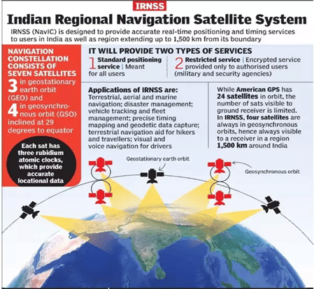
- NavIC or the Indian Regional Navigation Satellite System (IRNSS) is designed with a constellation of 7 satellites and a network of ground stations operating 24×7.
- There are a total of eight satellites however only seven remain active.
- Three satellites in geostationary orbit and four satellites in geosynchronous orbit.
- The constellations' first satellite (IRNSS-1A) was launched on 1st July 2013 and the eighth satellite IRNSS-1I was launched in April 2018.
- It is fully under the control of the Government of India.
How will NavIC provide service?
- NavIC offers two services:
- Standard Position Service (SPS) for civilian users and
- Restricted Service (RS) for strategic users.
- These two services are provided in both L5 (1176.45 MHz) and S band (2498.028 MHz).
- The coverage of NavIC extends over India and stretches up to 1,500 km beyond its borders.
- Upcoming satellites will introduce an extra L1 band, tailored for civilian applications, further enhancing compatibility and utility.
Significance of the merger
- The integration of NavIC (Navigation with Indian Constellation) into Aadhaar enrolment devices aims to enhance their accuracy and reliability.
- Currently, these devices are linked to the Global Positioning System (GPS) for collecting and verifying personal details during Aadhaar enrolment.
- The Department of Space (DoS) has successfully conducted field trials and is now providing technical expertise to finalize the procurement specifications for these devices.
- The inclusion of NavIC technology will provide several benefits, including improved navigation accuracy and enhanced disaster management capabilities.
NavIC for Disaster Management
|
(*Click this link to read prelims specific weekly current affairs articles)
FAQs
Question: What is NavIC?
Answer:
NavIC or the Indian Regional Navigation Satellite System (IRNSS) is designed with a constellation of 7 satellites and a network of ground stations operating 24×7.
Question: What are the organizations working with NavIC data?
Answer:
NavIC standards were set by the Bureau of Indian Standards (BIS), Telecom Standards Development Society, India (TSDSI), Telecom Engineering Centre (TEC), Third Generation Partnership Project (3GPP), and Radio Technical Commission for Maritime Services (RTCM), International Electrotechnical Committee (IEC), and International Standards Organisation (ISO).
Question: What is the Global Positioning System (GPS)?
Answer:
Global positioning system also known as GPS is a navigation device. It is based on the radio navigation system and locates places with the help of satellites present in the thermosphere layer of the atmosphere. It can be used anywhere on the Earth to determine the location. That area can be land, sea, ocean, or air.
UPSC Mains Practice Question:
|
MCQs
Question: Which of the following countries have their own navigation system? (UPSC 2023)
(a) Australia
(b) Canada
(c) Israel
(d) Japan
Answer: (d) See the Explanation
- There are four global satellite-based navigation systems —
- the American GPS,
- the Russian GLONASS (GLObalnaya NAvigatsionnaya Sputnikovaya Sistema),
- the European Galileo, and
- the Chinese Beidou.
- Quasi-Zenith Satellite System (QZSS) is a regional GNSS owned by the Government of Japan and operated by QZS System Service Inc. (QSS). QZSS complements GPS to improve coverage in East Asia and Oceania.
Therefore, option (d) is the correct answer.
Question: With reference to the Indian Regional Navigation Satellite System (IRNSS), consider the following statements: (UPSC 2018)
- IRNSS has three satellites in geostationary and four satellites in geosynchronous orbits.
- IRNSS covers the entire India and about 5500 sq. Km beyond its borders.
- India will have its own satellite navigation system with full global coverage by the middle of 2019.
Which of the statements given above is/are correct?
(a) 1 only
(b) 1 and 2 only
(c) 2 and 3 only
(d) None
Answer: (a) See the Explanation
In IRNSS, Out of the seven satellites of space segment; four satellites are in geosynchronous orbit and three satellites are in geostationary orbit.
Therefore, option (a) is the correct answer.
Download the PREPP App and attempt FREE IAS Exam Mock Tests and get complete study material!

Full Test - 04: UPSC CSE Prelims CSAT (Paper-II)
Full Test - 03: UPSC CSE Prelims CSAT (Paper-II)
UPSC CSE Prelims 2026 GS Paper 1 Question Paper (24-May-2026)
UPSC CSE Prelims 2026 CSAT Paper 2 Question Paper (24-May-2026)

17 February 2025 | The Hindu Must Read Articles | Current Affairs

16 February 2026 | The Hindu Must Read Articles | Current Affairs

13 February 2026 | The Hindu Must Read Articles | Current Affairs









Comments