Effects of Earthquakes - Geography Notes
Earthquakes are the result of the release of energy from Earth generating vibrations and shaking. Dangerous effects of earthquakes are ground shaking, ground rupture, landslides, tsunamis, damage to buildings, and liquefaction. Fires are the most destructive secondary effect of earthquakes. Earthquake causes damage to people's lives and property if the magnitude is higher. The topic “Effects of Earthquakes” is an important part of the UPSC/IAS Exam Geography syllabus which is discussed in this article in detail.
|
Table of Contents |
What is an Earthquake?
- An earthquake is the shaking of the surface of the Earth resulting from a sudden release of energy in the Earth's lithosphere that creates seismic waves.
- Earthquakes can range in size from those that are so weak that they cannot be felt to those violent enough to toss people around and destroy whole cities.
- Seismicity, or seismic activity, of an area refers to the frequency, type, and size of earthquakes experienced over a period of time. The word tremor is also used for non-earthquake seismic rumbling.
- Cause of earthquakes is often due to the movement of tectonic plates beneath the Earth's surface.
- When these plates move past each other, they sometimes get stuck at their edges due to friction.
- When the stress on the edge overcomes the friction, there is an earthquake that releases energy in the form of seismic waves, which causes the ground to shake.
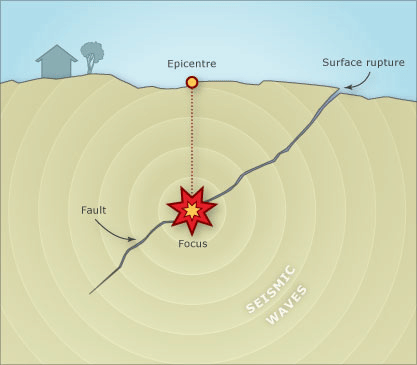
- The location below the Earth's surface where the earthquake starts is called the hypocenter, and the location directly above it on the surface is called the epicenter.
- Earthquakes can occur anywhere, but their most common sites are along tectonic plate boundaries.
Effects of Earthquakes
An earthquake is a natural disaster that can happen at any time. People's lives and property could be severely harmed if a large-magnitude of earthquake occurs. The following are the immediate dangers that an earthquake can cause:
- Ground tremors
- Tsunamis, landslides, mudslides, and avalanches
- Liquefaction of the soil
- Lurching and shifting of the ground
- Fires and floods
- Breakdown of the infrastructure
Let us look in detail at some disastrous consequences:
Avalanches and Landslides
- Tremors, particularly in mountainous places, can result in slope instability and failure, resulting in debris falling down the slope and creating landslides.
- Avalanches caused by earthquakes may cause massive amounts of ice to cascade down snow-covered peaks.
- During the 2015 Nepal earthquake, multiple avalanches occurred on and around Mount Everest.
- The 2011 earthquake in Sikkim resulted in landslides and significant damage to lives and property, particularly at the Singik and Upper Teesta hydroelectric facilities.
Tsunami
- These are unusual waves that mostly originate from earthquakes.
- Tsunamis are caused by earthquake seismic waves displacing the seafloor and generating high sea waves.
- An earthquake off the coast of Sumatra triggered the Tsunami on December 26, 2004, in the Indian Ocean.
- The Indian plate was subducted beneath the Burmese plate, causing an earthquake.
- Around 2.4 lakh people were killed in the Indian Ocean region and its surrounding countries.
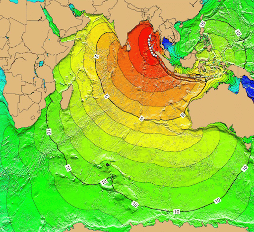
2004 Earthquake and Tsunami
- Tsunami waves of 10 meters were generated by the catastrophic Tohoku earthquake in Japan in 2011, which was caused by an underwater earthquake of magnitude 9.

Impact of Tsunami
Liquefaction
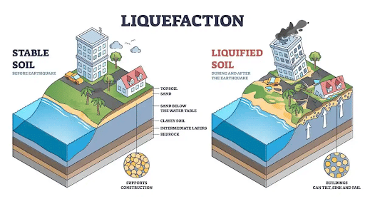
Liquefaction
- Liquefaction is a phenomenon in which the strength and stiffness of soil are reduced by earthquake shaking or another rapid loading.
- Liquefaction and related phenomena have been responsible for tremendous amounts of damage in historical earthquakes around the world.
- Earthquake waves get significantly amplified when they pass through soft ground.
- It is a sudden loss of strength of water-saturated soil resulting from shaking during an earthquake.
- It can cause large ground cracks to open.
- Shaking can cause saturated soils to consolidate and thus occupy a smaller volume.
- During the shaking of an earthquake, the water-saturated material turns fluid, resulting in subsidence fracturing and horizontal sliding of the ground surface.
- Landslides, mudslides, and other forms of mass movement often result from a combination of circumstances among which a quake can be crucial.
- For example, the 1964 Niigata earthquake caused widespread liquefaction in Niigata, Japan which destroyed many buildings.
- Also, during the 1989 Loma Prieta, California earthquake, liquefaction of the soils and debris used to fill in a lagoon caused major subsidence, fracturing, and horizontal sliding of the ground surface in the Marina district in San Francisco.

Impact of Liquefaction
Floods
- Dams, reservoirs, and flash floods might all be severely impacted by the earthquake.
- Floods can be caused by landslides and avalanches that restrict the river's flow.
- Due to the accumulation of large debris, the Assam earthquake of 1950 created a barrier in the Dihang River, creating flash floods in the upstream part.
- Sometimes secondary effects like fire can cause much more damage than the earthquake itself.
- Sometimes earthquakes can lead to the appearance or disappearance of physical features like lakes.
Measurement
|
| Other Relevant Links | |
|---|---|
| P Waves | S Waves |
| surface waves | Emergence of Shadow Zone |
| types of earthquakes | Seismic Activity |
| Gravitational Force | Magnetic Field |
Steps for Better Management of Earthquakes
- Earthquake management refers to the planning and coordination of resources and duties for dealing with all humanitarian elements of disasters.
- The goal is to lessen the dangers of negative consequences.
- Pre-earthquake risk reduction to post-earthquake recovery are all steps in earthquake management.
Risk Recognition
- The first step is to recognize which locations are more vulnerable to earthquakes than others.
- Study past earthquake occurrences to gauge the potential risk of future events.
Earthquake Monitoring System/Early Warning System
- It is still difficult to make an exact prediction regarding the occurrence of an earthquake in a certain region.
- Seismologists are increasingly focusing their efforts on earthquake prediction. It will aid in mitigating the effects of impending disasters.
- For example, Japan has an early warning system for earthquakes that employs electronic signals that travel quicker than seismic waves.
Structural Solution
- During previous earthquakes, almost 95 percent of people died as a result of structures that were not earthquake-resistant collapsing.
- However, the cost of constructing quake-resistant structures is higher than that of typical structures.
- As a result, finding a cost-effective solution for a country like India remains difficult.
- Seismic strengthening can be accomplished by prioritizing structures, and in order to do so, an earthquake hazard map for various zones based on vulnerability is required.

Early Warning System
Earthquake-prone Zones in India

Seismic Zone Map of India 2002
- Earthquakes threaten more than 55 percent of India's land area. Jammu & Kashmir, Himachal Pradesh, Uttarakhand, Sikkim, and the Darjiling and subdivision of West Bengal, as well as the seven northeastern states, are among the most vulnerable.
- Apart from these areas, major earthquakes have struck India's central-western states, particularly Gujarat and Maharashtra.
- Based on past seismic activity, the Bureau of Indian Standards divided the country into four seismic zones: Zones II, III, IV, and V.
- Zone V is the seismically most active, whereas Zone II is the least active.
- Zone I is not used in the present categorization of India into earthquake-prone zones.
- Zone-V comprises the entire north-eastern India, parts of Jammu and Kashmir, Himachal Pradesh, Uttarakhand, Rann of Kutch in Gujarat, part of North Bihar and Andaman and Nicobar Islands.
- Zone-IV covers the remaining parts of Jammu and Kashmir and Himachal Pradesh, Delhi, Sikkim, the northern part of Uttar Pradesh, Bihar, West Bengal, parts of Gujarat, a small portion of Maharashtra near the west coast and Rajasthan.
- Zone-III comprises Kerala, Goa, Lakshadweep, and the remaining parts of Uttar Pradesh, Gujarat, and West Bengal, parts of Punjab, Rajasthan, Madhya Pradesh, Bihar, Jharkhand, Chhattisgarh, Maharashtra, Odisha, Andhra Pradesh, Tamil Nadu, and Karnataka.
- Zone-II covers the remaining parts of the country.
Conclusion
The repercussions of earthquakes reverberate far beyond the immediate devastation of infrastructure and loss of life. They serve as poignant reminders of the dynamic nature of our planet and the vulnerabilities of human establishments. Earthquakes not only reshape landscapes but also have long-term economic, social, and psychological effects on affected populations.
FAQs
Question: What are the primary effects of an earthquake?
Answer: The primary effects include ground shaking, ground rupture, and faulting, which directly damage structures and landscapes.
Question: What are the secondary effects of earthquakes?
Answer: Secondary effects include landslides, tsunamis, and liquefaction, often causing widespread destruction and loss of life.
Question: What is liquefaction in the context of earthquakes?
Answer: Liquefaction occurs when saturated soil temporarily loses its strength due to shaking, leading to buildings sinking or tilting.
Question: How do earthquakes trigger tsunamis?
Answer: Underwater earthquakes can displace large volumes of water, causing tsunamis that lead to massive destruction along coastlines.
Question: Which areas are most affected by earthquakes?
Answer: Earthquake-prone areas are located along tectonic plate boundaries, such as the Pacific Ring of Fire, Himalayan region, and San Andreas Fault.
MCQs
1. What causes tsunamis during an earthquake?A) Ground shaking
B) Volcanic eruptions
C) Displacement of water due to underwater seismic activity
D) Wind currents
Answer: (C) See the Explanation
Explanation: Tsunamis are caused by underwater earthquakes displacing large volumes of water.
A) Ground rupture
B) Liquefaction
C) Shaking
D) Faulting
Answer: (B) See the Explanation
Explanation: Liquefaction is a secondary effect where saturated soil loses strength due to shaking.
A) Richter Scale
B) Beaufort Scale
C) Mercalli Scale
D) Fujita Scale
Answer: (A) See the Explanation
Explanation: The Richter Scale measures the magnitude of earthquakes based on energy released.
A) Tectonic plate movements
B) Volcanic eruptions
C) Wind storms
D) Ocean currents
Answer: (A) See the Explanation
Explanation: Ground shaking is caused by the sudden movement of tectonic plates during an earthquake.
A) A fault line in Europe
B) An area with frequent earthquakes and volcanic eruptions around the Pacific Ocean
C) A tectonic plate boundary in Africa
D) A volcanic island in the Atlantic Ocean
Answer: (B) See the Explanation
Explanation: The Pacific Ring of Fire is an area around the Pacific Ocean known for frequent seismic activity.
GS Mains Questions and Model Answers
Q1: Discuss the primary and secondary effects of earthquakes on infrastructure and human settlements.
Model Answer: Earthquakes cause primary effects like ground shaking, which damages buildings, bridges, and roads. Secondary effects such as landslides, liquefaction, and tsunamis result in further destruction. Urban areas face extensive infrastructure damage, loss of life, and economic disruption. Preparedness through resilient infrastructure, zoning laws, and early warning systems can help mitigate these impacts.
Q2: Analyze the role of tectonic plate movements in causing earthquakes.
Model Answer: Earthquakes are primarily caused by the movement of tectonic plates. When plates collide, separate, or slide past each other, they release energy that causes ground shaking. Areas located at plate boundaries, such as the Himalayas and Pacific Ring of Fire, are highly prone to earthquakes. Understanding these movements helps in identifying high-risk zones and implementing disaster management strategies.
Q3: Examine the impact of tsunamis caused by underwater earthquakes on coastal areas.
Model Answer: Underwater earthquakes displace large volumes of water, creating tsunamis that inundate coastal areas, causing widespread destruction. The effects include loss of life, damage to infrastructure, displacement of populations, and long-term economic impacts. Effective early warning systems and coastal protection measures are crucial in reducing the devastation caused by tsunamis.
Previous Year Questions on Earthquakes
1. UPSC CSE Prelims 2020
Question: What is liquefaction in the context of earthquakes?
A) Formation of magma
B) Conversion of solid ground into liquid-like state during an earthquake
C) Melting of ice caps
D) Displacement of tectonic plates
Answer: B
Explanation: Liquefaction occurs when shaking during an earthquake causes saturated soil to behave like a liquid.
2. UPSC CSE Mains 2019
Question: Discuss how earthquakes can lead to secondary disasters like tsunamis and landslides.
Model Answer: Earthquakes often trigger tsunamis when underwater tectonic shifts displace water, causing massive waves that devastate coastal areas. Landslides occur in hilly areas when ground shaking destabilizes slopes, causing them to collapse. These secondary disasters amplify the destruction caused by earthquakes, necessitating comprehensive disaster preparedness plans.
Download the PREPP App and attempt FREE IAS Exam Mock Tests and get complete study material!

Full Test - 04: UPSC CSE Prelims CSAT (Paper-II)
Full Test - 03: UPSC CSE Prelims CSAT (Paper-II)
UPSC CSE Prelims 2026 GS Paper 1 Question Paper (24-May-2026)
UPSC CSE Prelims 2026 CSAT Paper 2 Question Paper (24-May-2026)

17 February 2025 | The Hindu Must Read Articles | Current Affairs

16 February 2026 | The Hindu Must Read Articles | Current Affairs

13 February 2026 | The Hindu Must Read Articles | Current Affairs









Comments