The Changing Contours Of Delhi
Relevance: GS 2 - Government policies and interventions for development in various sectors and issues arising out of their design and implementation; GS 1 - Urbanization, their problems and their remedies; Population and associated issues
(Source: The Hindu, 07/27/23)
Click here for Daily Current Affairs
Why in the news?
India's recent declaration as the world's most populous country, coupled with the exponential growth of cities like Delhi-NCR, highlights the urgent need for equitable and sustainable economic development planning. The capital city's imminent transformation into the world's largest urban agglomeration by 2028 intensifies the focus on addressing infrastructure disparities. As the engines of India's growth, mega city-regions like Delhi-NCR require specific policies beyond national and State-level initiatives to accommodate the needs of their burgeoning population, especially the young demographic with a median age of 28.2.
Table of Contents
Delhi’s contribution to economy
- National Capital Region (NCR) is a unique example of inter-state regional planning and development for a region with NCT-Delhi as its core. It is set to become the world’s most populous urban agglomeration overtaking Tokyo by 2028.
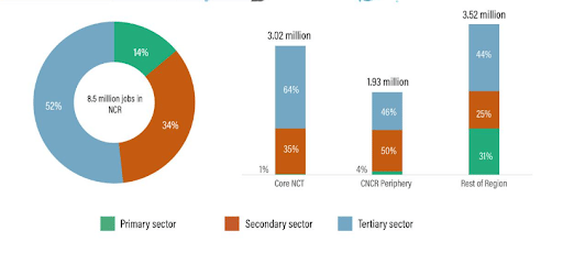
- Employment: Delhi-NCR has the highest concentration of jobs and people in the country, and generated a GDP of $370 billion in 2015. The region’s per capita income has tripled, and consumption levels have risen
- Growth across sectors: Industrial sectors that experienced growth created more employment compared to technical and energy-efficient sectors.
- Traditional sectors like trade, textiles, and leather remain dominant but contribute less to the region's GDP.
- Overall, employment-intensive growth in the secondary and tertiary sectors has been limited.
Challenges
- Fragmented development: Decentralized policies, coupled with land-use and building control restrictions, pollution control norms, and inefficient land acquisition and disposal policies, have contributed to the fragmented development driven by speculation beyond the boundaries of Delhi.
- Lagging in Infrastructure: The peripheral contiguous cities lag behind the core of the Delhi National Capital Territory (Delhi-NCT) in terms of infrastructure.
- Unplanned urbanization: Unplanned urbanization in Delhi has happened at the expense of natural resources. Delhi’s forest cover has reduced by half from 1998 to 2018, according to a study.
- Growing income inequality: Informalization of jobs, unemployment rates have increased, and women’s participation in the workforce remains low.
- Lack of transition in economy: According to the ‘Morphology of Delhi National Capital Region’s Economic Geography and its Implications for Planning’, rapid horizontal built-up area expansion, and infrastructure development, has not been followed by a shift to a high-wage, knowledge-based economy in the core area.
What needs to be done?
- Economic geography approach: It can provide an interdisciplinary understanding of economic activity and its impacts on people which will help in identifying the reasons behind economic activity occurring in specific regions.
- It emphasizes the uniqueness of each location, recognizing that no two places are alike.
- Region-specific economic development: The creation of a region-specific economic development corporation to promote healthy competition between cities and states to attract investments.
- A multi-stakeholder platform involving the government, private sector, academia, and civil society would address development needs.
- Spatio-economic assessments: Spatio-economic assessments can help target infrastructure investments and foreign direct investments to economically dynamic locations, to ensure better returns and job growth.
- It can also help improve access to education, healthcare, basic services, and jobs for marginalized groups.
- Participation of women: Participation of women in the workforce can be promoted by making safe and accessible work and travel, with child and elder care facilities.
Conclusion
- An economic geography-based assessment framework can facilitate better planning and investment decisions at the regional and local levels, guide investment decisions, factor in environmental impacts, and facilitate the inclusion of marginalized groups in the economy. Thus, it can help ensure well-planned, and inclusive economic growth, and support a higher quality of life while also valuing planetary resources.
(*Click this link to read prelims specific weekly current affairs articles)
FAQs
Question: What is NCR?
Answer:
According to the National Capital Region Planning Board Act 1985, total 19 districts in the adjoining states of Uttar Pradesh, Haryana and Rajasthan as well as the National Capital Territory of Delhi comprise the National Capital Region (NCR) of India.
- National Capital Territory Delhi.
- Haryana:- Faridabad, Gurgaon, Rohtak, Sonipat, Panipat, Jhajjar, Rewari, Mewat, Palwal, Bhiwani, Mahendragarh, Jind and Karnal districts.
- Uttar Pradesh:- Meerut, Ghaziabad, Gautam Budh Nagar, Buland Shahar, Baghpath, Hapur districts.
- Rajasthan:- Alwar, Bharatpur districts
Question: What is Urban Agglomeration?
Answer:
The term “urban agglomeration” refers to the population contained within the contours of a contiguous territory inhabited at urban density levels without regard to administrative boundaries. It usually incorporates the population in a city or town plus that in the suburban areas lying outside of, but being adjacent to, the city boundaries.
Question: What is Economic Geography?
Answer:
Economic Geography is a sub-discipline of geography that is concerned with the spatial configuration of firms, industries and nations.
Download the PREPP App and attempt FREE IAS Exam Mock Tests and get complete study material!

Full Test - 04: UPSC CSE Prelims CSAT (Paper-II)
Full Test - 03: UPSC CSE Prelims CSAT (Paper-II)
UPSC CSE Prelims 2026 GS Paper 1 Question Paper (24-May-2026)
UPSC CSE Prelims 2026 CSAT Paper 2 Question Paper (24-May-2026)

17 February 2025 | The Hindu Must Read Articles | Current Affairs

16 February 2026 | The Hindu Must Read Articles | Current Affairs

13 February 2026 | The Hindu Must Read Articles | Current Affairs









Comments