India And The Northern Sea Route
Relevance: GS1- Distribution of key natural resources across the world (including South Asia and the Indian subcontinent) GS2 - Bilateral, regional and global groupings and agreements involving India and/or affecting India’s interests.
(Source: The Hindu, 08/24/2023)
Click here for Daily Current Affairs
Why in the news?
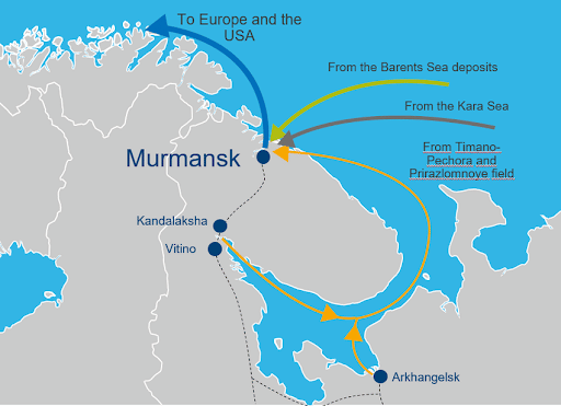
- In 2023, almost 35% of the 8 million tonnes of cargo handled by Murmansk port in northwest Russia was for India.
- This article discusses the North Sea route, its importance for India, and the opportunities and challenges presented by it.
Table of Contents
- What is the Northern Sea Route?
- Advantages
- Challenges
- Why is the Arctic region significant to India?
- How old is India’s engagement with the Arctic?
- How is Russia making the NSR navigable?
- What are the driving factors for India to participate in the NSR development?
- What lies forward?
- Conclusion
- FAQs
- MCQs
What is the Northern Sea Route?
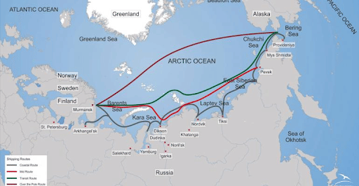
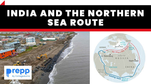
- The Northern Sea Route or NSR is the shortest shipping route for freight transportation between Europe and the Asia-Pacific region.
- It is around 5,600 km long and extends between the Barents and the Kara Seas (Kara Strait) and ends in the Bering Strait (Provideniya Bay).
- The NSR is around half the distance covered by currently used shipping lanes such as the Suez Canal which can lead to savings as high as 50%.
- The blockage of the Suez Canal in 2021 by Ever Given raised the need for an alternate route to the Suez.
Advantages
- Geoeconomic benefits:
- It can become a global energy superhighway for the transport of various natural resources like hydrocarbons, from the Arctic.
- It can help establish strong supply networks to the Arctic which will ensure the uninterrupted flow of cargo.
- As the NSR is entirely within the Russian EEZ, it can help Russia gain more influence on the global stage.
- Economically profitable:
- The reduced distance of the route leads to fuel savings and reduced costs for staff labor and chartering vessels.
- The Northern Sea Route does not charge payments for passage, unlike the Suez Canal.
- There are no queues in the NSR like in the Suez Canal.
- The NSR is also free from piracy which affects the Suez Canal.
Challenges
- The Arctic region is not a hospitable environment and is becoming progressively more unstable as global warming continues.
- The surface temperatures in the region are rising twice as fast as in other regions of the world.
- The stability of the polar vortex is reducing due to the frequent occurrences of extreme cold in Russia and Europe,
- The unusual jetstream patterns are also altering the paths of the northern storms in the region.
- The unpredictable weather conditions impact the working of ships and workers, search-and-rescue resources, and infrastructure.
- The shallow depth of the Laptev Strait restricts the size of ships that can pass through the route.
- The NSR is minimally policed leading to concerns over its use for the transport of illegal goods, weapons, etc.
- The region has become another site of geopolitical contest between Russia and NATO on account of the presence of what is believed to be one-fourth of the world’s untapped petroleum reserves.
Why is the Arctic region significant to India?
- The Arctic Region, including the Arctic Circle, the Arctic Ocean, and the North Pole, is vulnerable to the unprecedented nature of climate change.
- This could have a direct impact on India’s economic security, water security, and sustainability.
- It is the largest unexplored prospective area for hydrocarbons with estimates of over 40% of the current global reserves of oil and gas and significant reserves of coal, zinc, and silver.
- However, the government’s Arctic Policy of 2022 mentions that the country’s approach to economic development of the region is guided by UN Sustainable Development Goals.
How old is India’s engagement with the Arctic?
- India’s relationship with the Arctic began with the signing of the Svalbard treaty in 1920.
- India is performing scientific studies and research in atmospheric, biological, marine, hydrological, and glaciological studies in the region.
- India set up the Himadri research station at Ny-Ålesund, Svalbard, in 2008, a multi-sensor moored observatory in 2014, and the northernmost atmospheric laboratory in 2016.
- India became an observer state in the Arctic Council in May 2023.
How is Russia making the NSR navigable?
- Icebreaking assistance is necessary to ensure safe navigation through the Northern Sea Route, as the seas in the Arctic are ice-bound for most of the year.
- Russia is the only country that possesses a nuclear-powered icebreaker fleet, which is operated by FSUE Atomflot, a subsidiary of Rosatom State Nuclear Energy Corporation which is the NSR infrastructure operator.
- The fleet consists of seven nuclear-powered icebreakers and one nuclear container ship with three more to be commissioned between 2024 and 2027.
- Lenin, the first nuclear-powered icebreaker in the world was commissioned in 1959 and decommissioned in 1989.
What are the driving factors for India to participate in the NSR development?
- Rising trade: The growth in cargo traffic along the NSR was around 73% between 2018 and 2022 and is continuously rising.
- India’s imports of record amounts of oil and coal from Russia in recent years have been made possible by the reliable and safe NSR.
- Geographical positioning: The majority of India’s trade is via the sea route.
- Therefore, the NSR which is shorter, safer, and thus cheaper than routes such as the Suez Canal is a viable prospect for India.
- Chennai-Vladivostok Maritime Corridor (CVMC) project: The Chennai-Vladivostok Maritime Corridor is directly linked to the organized shipping terminal through the NSR.
- The CVMC, which passes through the Sea of Japan, the South China Sea, and the Malacca strait is around 10,500 km long as compared to the currently used Mumbai-St. Petersburg route which is 16,000 km long.
- The CVMC route will reduce the transit time from Russia to India by one-third to 12 days.
- Chinese influence: The strong partnership and alliance between Russia and China could extend to the Arctic region.
- This is a major concern for India due to its geopolitical tensions with China and its reliance on the NSR for cheap, safe, and efficient transport of its exports and imports.
What lies forward?
- The NSR development plan which was approved by the Russian government in 2022 set a cargo traffic target of 80 million tonnes and 150 million tonnes for 2024 and 2030 respectively.
- In March 2023, a Russian delegation held meetings with the Indian business community on the development of the NSR, and Indian partnerships in the NSR and promised to ensure the year-round operation of the route.
Murmansk Port
|
(*Click this link to read prelims specific weekly current affairs articles)
FAQs
Question: What is the Arctic Council?
Answer:
The Arctic Council is a consensus-based intergovernmental forum for cooperation and coordination among the Arctic States, indigenous communities, and other inhabitants on issues of common concern such as sustainable development and environmental protection. Members include Canada, Denmark, Finland, Iceland, Norway, Sweden, Russia, and U.S.A. India is an observer state.
Question: What is an EEZ?
Answer:
According to the UN Convention on the Law of the Sea (UNCLOS), an Exclusive Economic Zone (EEZ) is a zone in the sea over which a sovereign nation has certain special rights related to the exploration and usage of marine resources, such as energy from wind, water, and oil and natural gas extraction. It lies adjacent to and beyond the territorial sea.
UPSC Mains Practice Question:
|
MCQs
Question: Consider the following countries:
- Denmark
- Japan
- Russian Federation
- United Kingdom
- United States of America
Which of the above are the members of the ‘Arctic Council’? (UPSC CSE 2014)
(a) 1, 2 and 3
(b) 2, 3 and 4
(c) 1, 4 and 5
(d) 1, 3 and 5
Answer: (d) See the Explanation
- The Arctic Council was established in 1966 as an intergovernmental forum for cooperation, and coordination among the Arctic States
- Members: Canada, Denmark, Finland, Iceland, Norway, Russia, Sweden and the United States.
- Both the United Kingdom and Japan have observer status.
Therefore, option (d) is the correct answer.
Question: The term ‘IndARC’, sometimes seen in the news, is the name of (UPSC CSE 2015)
(a) an indigenously developed radar system inducted into India's Defence
(b) India’s satellite to provide services to the countries of Indian Ocean Rim
(c) a scientific establishment set up by India in Antarctic region
(d) India’s underwater observatory to scientifically study the Arctic region
Answer: (d) See the Explanation
- IndARC is a multi-sensor Indian underwater observatory deployed in Kongsfjordan Fjord of the Arctic between Norway and North Pole.
- It will gather real-time data based on seawater temperature, salinity, ocean currents, and other parameters related to the fjord.
Therefore, option (d) is the correct answer.
Download the PREPP App and attempt FREE IAS Exam Mock Tests and get complete study material!

Full Test - 04: UPSC CSE Prelims CSAT (Paper-II)
Full Test - 03: UPSC CSE Prelims CSAT (Paper-II)
UPSC CSE Prelims 2026 GS Paper 1 Question Paper (24-May-2026)
UPSC CSE Prelims 2026 CSAT Paper 2 Question Paper (24-May-2026)

17 February 2025 | The Hindu Must Read Articles | Current Affairs

16 February 2026 | The Hindu Must Read Articles | Current Affairs

13 February 2026 | The Hindu Must Read Articles | Current Affairs









Comments