Eight Institutes Give An Array Of Reasons For Joshimath Sinking
Relevance: GS1 - Salient features of world’s physical geography, Important Geophysical phenomena such as earthquakes, Tsunami, Volcanic activity, cyclone etc., geographical features and their location-changes in critical geographical features (including water-bodies and ice-caps) and in flora and fauna and the effects of such changes GS3 - Conservation, environmental pollution and degradation, environmental impact assessment. Disaster and disaster management.
(Source: The Hindu, 09/26/2023)
Click here for Daily Current Affairs
Why in the news?
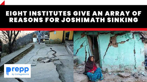
- Recently, separate studies conducted by eight premier Institutes of India identified various reasons for the land subsidence in Joshimath, Uttarakhand.
- According to the report, seismic activities, construction loopholes, population pressure, and poor drainage systems are among the most ‘likely’ reasons for the sinking of the Himalayan town.
Table of Contents
Which are the Eight Institutes that have prepared reports on the land subsidence at Joshimath?
- The government had mandated the following institutions to identify the causes of the land subsidence at Joshimath.
- Wadia Institute of Himalayan Geology (WIHG)
- National Geophysical Research Institute (NGRI)
- National Institute of Hydrology (NIH)
- Indian Institute Of Technology (IIT-Roorkee)
- Indian Institute of Remote Sensing (IIRS)
- Geological Survey of India (GSI)
- Central Ground Water Board (CGWB)
- Central Building Research Institute (CBRI)
What have the reports stated?
WIHG
- Earthquakes in the area are a major reason for the slow and gradual land subsidence.
- It highlighted the need for LiDar sensors to provide bare-ground topography and surface models as it will make planning of management and mitigation convenient.
NGRI
- Certain areas of the town have sunk vertically by over 3 feet and have been displaced by over 1.4 feet.
- Steep air-filled fissures in excess of 100 feet were found in areas with loose soil cover and the absence of sub-surface rocks.
- Land cover analysis of satellite data revealed that there was a 100% increase in built-up area in the region between 2010 and 2020.
NIH
- The report stated that land subsidence and subsurface water might be connected based on evidence from maps of springs, drainage networks, and subsidence areas of the Joshimath region.
- It gave a clean chit to the NTPC as samples of water taken from the NTPC sites differed in terms of isotopic and water quality signatures from the samples taken from the JP site and drains and springs in Joshimath.
- Bacteriological analysis showed that the gush water was fresh and not contaminated by the local drain.
- It recommended the safe disposal of water from higher up and prioritizing the town’s waste disposal.
IIT Roorkee
- The soil fabric of Joshimath is a complex mixture of boulders, gravel, and soil.
- Internal erosion caused by rainwater infiltration and wastewater discharge affects the stability and results in the readjustment of the boulders, and subsequently subsidence.
- It recommended controlling water infiltration to minimize internal erosion.
IIRS
- ISRO utilized the Small Baseline Subset (SBAS) Interferometry SAR technique to analyze the subsidence in Joshimath.
- Subsidence leading to ground and structural was attributed to phenomena like
- toe-cutting
- slope instability due to drainage water seepage
- terrain characteristics
- loose moraine materials
- recent flash flood events.
GSI
- The Geological Survey of India (GSI) recommended ground-based terrestrial monitoring in different parts of Joshimath.
CGWB
- It stated that Joshimath’s location and geographic factors contributed to the crisis.
- It recommended an immediate halt to construction activities in the spring zone area and the clearing of any concrete material covering the emergence of springs.
CBRI
- Construction in Joshimath town is not compliant with the provisions of the National Building Code of India, 2016.
- The town has masonry (44%), RCC (42%), and other construction typologies (14%) of which 99% are non-engineered.
- The town is located on the Vaikrita group of rocks overlain by moraine deposits of irregular boulders and clays of varying thicknesses, which are less cohesive and thus more susceptible to slow subsidence and landslide subsidence.
- There has been a history of creeping and occasional subsidence in the region.
- The CBRI suggested that there is a need to review the principles of town planning in mountainous regions focusing on good construction practices, materials, regulatory mechanisms, and awareness among stakeholders based on geo-technical and geo-climatic conditions.
What have environmental activists claimed?
- Infrastructure projects: Concerns have been raised about the infrastructural development in the area such as the NTPC project and the Chardham road widening.
- Poor implementation: Questions were also asked about the lack of implementation of recommendations made after previous disasters and the absence of any regulations on tourism in the region.
- Repeated suggestions: Some environmental experts suggested that the findings were similar to previous committee reports.
Other reports
- In 2022, the Uttarakhand government's expert panel found that several areas of Joshimath are sinking and that the removal or displacement of subsurface materials has induced structural defects and damage.
- In 1976, the report prepared by the Mishra Committee identified that Joshimath lies on a deposit of sand and stone and not on the main rock.
- The river currents of Alaknanda and Dhauliganga are also a factor behind the landslides.
- Sinking could have been triggered by the reactivation of a geographic fault where the Indian Plate has pushed under the Eurasian Plate.
- It recommended restrictions on heavy construction work, blasting, and digging to remove boulders, tree felling, etc.
Joshimath
- Joshimath is a hilly town in the Chamoli district of Uttarakhand.
- Chamoli district experienced frequent landslides and flooding in 2021, with reports of cracks on walls and buildings.
- It is situated in a geologically unstable region (Seismic Zone V) and north of the Main Central Thrust (of the Himalayas) near the Tapovan Fault.
Cultural significance
- Joshimath is also known as the "winter seat" of Lord Badrinath as the idol of the Badrinath temple is brought down to the Vasudeva temple in Joshimath annually.
- The town acts as the gateway to the Sikh holy shrine Hemkund Sahib.
- It is home to one of the four cardinal maths or monasteries established by Adi Shankara besides Sringeri (Karnataka), Dwarka (Gujarat), and Puri (Odisha).
Way Forward
- The development strategy for the Himalayas should be based on the region’s natural resources such as biodiversity, ecotourism, etc., and account for the ecological risks faced by the region.
- There should be a focus on small projects that would provide energy supply to the locals instead of large hydroelectric projects.
- Traditional knowledge, agricultural practices, construction practices, and local culture should be used to develop policies for the region.
- The Government should actively implement the suggestions made by the committee reports unlike earlier.
- Agriculture must be encouraged in the Himalayan region of Uttarakhand as fallow land has increased in the state.
Conclusion
- Land subsidence in Joshimath is complex and has been influenced by multiple factors.
- The studies conducted by these premier institutions provide insight into the reasons behind them and emphasize the need for comprehensive disaster management and sustainable development in mountainous regions.
(*Click this link to read prelims specific weekly current affairs articles)
FAQs
Question: What is land subsidence?
Answer:
According to the National Oceanic and Atmospheric Administration (NOAA), land subsidence is the sinking of the ground because of underground material movement. It can be caused by gradual settling or sudden sinking of the Earth’s surface.
Question: What are moraines?
Answer:
Moraines are huge amounts of rock and dirt that have been pushed aside by the movement of glaciers, or huge debris of rock and dirt that has fallen onto the glacier surface. Moraines can be classified as ground, lateral, medial, or terminal moraines depending on their position.
UPSC Mains Practice Question:
|
MCQs
Question: When you travel in the Himalayas, you will see the following? (UPSC CSE 2012)
- Deep gorges
- U-turn river courses
- Parallel mountain ranges
- Steep gradients causing land-sliding
Which of the above can be said to be the evidence for the Himalayas being young fold mountains?
(a) 1 and 2 only
(b) 1, 2 and 4 only
(c) 3 and 4 only
(d) 1, 2, 3 and 4
Answer: (d) See the Explanation
- The Himalayas are a system of young fold mountains that were formed around 50 million years ago due to the folding of the edges of the Eurasian and Indo-Australian plates.
- Evidence for the young fold nature of the Himalayas includes deep gorges, V-shaped valleys, U-turn river courses, parallel mountain ranges, steep slopes, etc.
Therefore, option (d) is the correct answer.
Download the PREPP App and attempt FREE IAS Exam Mock Tests and get complete study material!

Full Test - 04: UPSC CSE Prelims CSAT (Paper-II)
Full Test - 03: UPSC CSE Prelims CSAT (Paper-II)
UPSC CSE Prelims 2026 GS Paper 1 Question Paper (24-May-2026)
UPSC CSE Prelims 2026 CSAT Paper 2 Question Paper (24-May-2026)

17 February 2025 | The Hindu Must Read Articles | Current Affairs

16 February 2026 | The Hindu Must Read Articles | Current Affairs

13 February 2026 | The Hindu Must Read Articles | Current Affairs









Comments