After Central, Now Eastern Himalayas? Glacial Lake Outburst In North Sikkim Sparks Alert Across The State
Relevance: GS1 - Important Geophysical phenomena such as earthquakes, Tsunami, Volcanic activity, cyclone etc GS3 - Disaster and disaster management.
(Source: Down to Earth, 10/04/2023)
Click here for Daily Current Affairs
Why in the news?
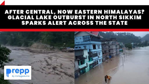
- Recently, a sudden glacial lake outburst took place in Chungthang in northern Sikkim leading to a rise in water level in the River Teesta.
- Glaciers are retreating due to climate change. The increase in the anthropogenic footprint in the glaciers leads to the increasing threat of GLOFs, and over 200 glaciers in the Himalayas are vulnerable to outbursts.
- A Glacial Lake Outburst Flood on October 4th, 2023 which originated from portions of the Lhonak Lake in the Mangan District of North Sikkim has resulted in a catastrophic rise in the water levels and velocity downstream along the Teesta River Basin.
- It resulted in a sudden surge of water, with velocities going as high as 15 meters per second.
- A flash flood alert was issued in Sikkim after a cloud burst took place in Singtam.
- The State Disaster Response Force (SDRF) teams from the State Home Guard and Civil Defence and National Disaster Response Force (NDRF) have been deployed.
Table of Contents
Impact
- The Chungthang Dam was damaged leading to rise in the Teesta’s water levels and the closure of the Sikkim-Kalimpong road.
- Transportation was disrupted by damage to the Phidang Bridge in Lower Dzongu and the Toong Bridge in Munthan.
- Flooding has affected various areas, with residents in low-lying regions, such as Singtam and Rangpo advised to relocate.
What is a Glacial Lake Outburst Flood?
- These floods are typically triggered by the rapid melting of glaciers, heavy precipitation, or the inflow of meltwater. In February 2021, Chamoli district in Uttarakhand experienced flash floods suspected to have been caused by GLOFs.
- GLOFs are generally caused by
- rapid melting of glaciers
- heavy precipitation
- inflow of meltwater.
- According to a study published in Nature in February, around 15 million people across the world are at risk of sudden and deadly flooding from glacial lakes, which are expanding and rising in numbers due to global warming.
- India, Pakistan, Peru, and China account for more than half of the people at risk.
- Previous instance: In 2013, flash floods occurred in Uttarakhand as a result of heavy rainfall and a GLOF caused by the Chorabari Tal glacial lake which resulted in the death of thousands and extensive infrastructural and property damage
How can GLOFs be mitigated?
- Identification of at-risk lakes: The government must identify hazardous lakes through field observations, and an analysis of historical records, geomorphological and geotechnical features, and other physical conditions.
- Adoption of Technology: Synthetic-Aperture Radar (SAR) imagery can automatically detect changes in water bodies such as the formation of new lakes during the monsoon season.
- Channeling Potential Floods: Controlled methods such as breaching, pumping, siphoning, or creating tunnels through moraine barriers or under ice dams will help reduce the volume of water in glacial lakes.
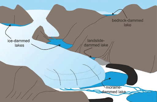
- A terminal moraine creates a barrier which traps water in a glacial lake, which is called a moraine-dammed lake.
- Uniform Construction Codes: The government must formulate comprehensive guidelines for infrastructure development, construction, and excavation in vulnerable areas.
- It must also create a proper framework for land-use planning procedures in GLOF-prone regions.
- Early Warning Systems (EWS): Expansion and improvement of the early warning systems for GLOFs in use to a global standard.
- In some Himalayan regions, sensor- and monitoring-based technical systems have been implemented to provide early warnings.
- Human resource capacity building: Local communities play a major role in search and rescue, as well as conservation efforts which must be recognized and tapped by the government.
- Over 80% of search and rescue operations are often carried out by local communities before official intervention.
- The NDMA has recommended training local personnel in disaster response activities in order to ensure lower casualties.
- Comprehensive alarm systems: Alarm infrastructure can be modernized by incorporating technologies like smartphones and social media to complement traditional siren-based alarms.
- Rehabilitation: Existing infrastructure and human populations, including illegal habitations must be relocated from at-risk riparian basins.
River Teesta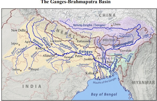
|
(*Click this link to read prelims specific weekly current affairs articles)
FAQs
Question: What is a cloudburst?
Answer:
A very sudden and heavy rainfall that is confined to a small area is called a cloudburst. When a small area receives more than 100 mm of rain in around one hour, it is said to be a cloud burst.
Question: What is the NDMA?
Answer:
The National Disaster Management Authority (NDMA) is the apex statutory body for disaster management in India. It was established under the Disaster Management Act, 2005 with the Prime Minister as its Chairperson and nine other members. It is mandated with coordinating responses to natural or man-made disasters, capacity-building in disaster resiliency and crisis response, and formulation of policies and guidelines for timely and effective response to disasters.
UPSC Mains Practice Question:
|
MCQs
Question: With reference to river Teesta, consider the following statements:
- The source of river Teesta is the same as that of Brahmaputra but it flows through Sikkim.
- River Rangeet originates in Sikkim and is a tributary of river Teesta.
- River Teesta flows into the Bay of Bengal on the border of India and Bangladesh.
Which of the statements given above is/are correct? (UPSC CSE 2017)
(a) 1 and 3 only
(b) 2 only
(c) 2 and 3 only
(d) 1, 2 and 3
Answer: (b) See the Explanation
- The Teesta River originates from the Pahunri glacier while the Bhramaputra originates from Chemayungdung glacier near Mansarovar in Tibet. Hence statement 1 is incorrect.
- The River Rangeet originates in Sikkim and is a right-bank tributary of river Teesta. Hence statement 2 is correct.
- The Teesta is one of the right-bank tributaries of the Brahmaputra and flows through West Bengal and Sikkim before flowing into the Bay of Bengal through Bangladesh. Hence statement 3 is incorrect.
Therefore, option (b) is the correct answer.
Download the PREPP App and attempt FREE IAS Exam Mock Tests and get complete study material!

Full Test - 04: UPSC CSE Prelims CSAT (Paper-II)
Full Test - 03: UPSC CSE Prelims CSAT (Paper-II)
UPSC CSE Prelims 2026 GS Paper 1 Question Paper (24-May-2026)
UPSC CSE Prelims 2026 CSAT Paper 2 Question Paper (24-May-2026)

17 February 2025 | The Hindu Must Read Articles | Current Affairs

16 February 2026 | The Hindu Must Read Articles | Current Affairs

13 February 2026 | The Hindu Must Read Articles | Current Affairs









Comments