Plateau and its Types - Geography Notes
Plateau is a raised flat area with one or more steep slopes. Plateau in general has a higher elevation than the rest of the region. A plateau is formed by the erosion of the nearby rivers, glacial activity, and flooding. The pressure of thick layers of rock within a magma chamber can cause an uplift of land. Plateaus are also called high plains or tablelands. The fundamental difference between a plateau and a mountain is the flat top of a plateau. India's Deccan plateau is one of the world's oldest plateaus. Plateaus can range in height from a few hundred meters to several thousand meters. This article will explain the Plateaus and its Types which will be helpful in Geography subject preparation for the UPSC Civil Service exam/IAS Exam.
| To Read update on this topic: |
|
Table of Contents |
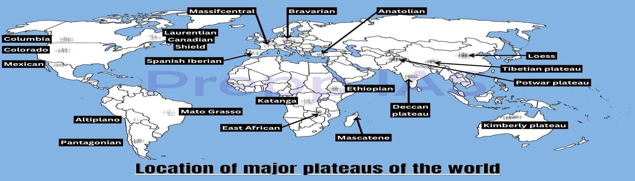
Distribution of Major Plateaus of the World
What exactly is a Plateau?
- A plateau is a raised flat area of land. It is a flat-topped table land that rises above the surrounding terrain.
- Plateaus can range in height from a few hundred meters to several thousand meters.
- Plateaus are similar to mountains in that they can be young or ancient.
- Generally speaking, plateaus are a highly widespread type of landform and may be found worldwide.
- The most common example of plateaus includes the East African Plateau in Kenya, Tanzania, and Uganda, as well as Australia's Western Plateau.
- The Tibet Plateau is the world's highest plateau, rising 4,000 to 6,000 meters above the mean sea level.
- Some of the world's most notable plateaus are the Anatolian Plateau, Columbia Plateau, Appalachian Plateau, Piedmont Plateau, Laurentian Plateau, Central Mexican Plateau, Altiplano Plateau, Guyana Highland, Patagonian Highland, Mongolian Plateau, and Central Siberian Plateau.

How is a Plateau Formed?
- A plateau is formed as a result of the surrounding land being eroded by rivers, floods, and glaciers.
- A plateau can also develop over time as a result of numerous lava flows.
- When magma rises up toward the crust's surface, a plateau is formed. Plateaus can arise in a variety of ways.
- Instead of breaking through the crust, the magma rises a portion of it, creating a plateau.
- It is also shaped by the effects that wind and water erosion on land areas over millions of years can have.
- A stream that flows in particular manner layers the rock over time and carves channels that continue to reach deep.
- The various process that creates the plateaus are volcanism (Deccan Plateau), crustal shortening (Tibetian Plateau), and thermal expansion (Ethiopian Highlands).
Features of Plateau
- Generally, plateaus have an abundance of mineral resources.
- As a result, many of the world's mining sites are situated on plateaus. Gold and diamond mining are well-known on the African plateau.
- The Chota Nagpur plateau in India contains massive amounts of iron, coal, and manganese.
- As the river falls from a large height in the plateau sections, there may be multiple waterfalls.
- The Hundru falls on the river Subarnarekha on the Chota Nagpur plateau and the Jog falls in Karnataka are two instances of such waterfalls in India.
- The lava plateaus have a lot of black soil, which is productive and suitable for farming.
- Many plateaus feature beautiful scenery and are popular with visitors.
- The black soil region known as Deccan Trap is one of the distinctive characteristics of the Peninsular plateau.
- The rocks are igneous because they are of volcanic origin. The boulders have depleted through time and are the cause of black soil development.
- The Aravalli Hills are located on the Peninsular Plateau's western and northern edges.
- These are degraded hills that appear like fractured hills.
- They run in a southwest-northeast direction from Gujarat to Delhi.
Different Types of Plateaus
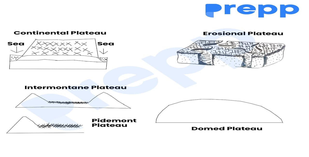
Different Types of Plateaus
Diastrophic Plateaus
- Diastrophism, as the name implies, is the large-scale deformation of the earth's crust that results in continents, basins, seas, and mountain ranges.
- As a result, all high plateaus are recognized to be caused by this activity and are referred to as diastrophic plateaus.
- Since the elevation of these landforms, they have been subjected to a variety of erosional processes.
- Minor earth movements, as well as volcanism, have an impact on them.
- The Ethiopian highlands and the Tibetan plateau are two examples of this sort of plateau.
- Diastrophism is responsible for all of the world's tallest plateaus.
- Since their uplifts, they have been altered by a variety of erosional forces, as well as volcanism and small earth movements in several cases.
- They can be categorized as-
- Intermontane Plateaus
- Mountain Border Plateaus
- Domed Plateaus
- Volcanic Plateaus
- Erosional Plateaus
Intermontane Plateaus
- An intermontane plateau is a plateau that is encircled or surrounded by mountain ranges.
- The Tibetan Plateau and the Mongolian Plateau are Asia's two intermontane plateaus.
- The world's tallest, biggest, and most complex plateaus are found in the Intermontane Plateaus.
- Their surfaces display a wide range of topographic characteristics.
- The Tibetan Plateau is the greatest example. The Tibetan Plateau is bordered on the north by the Kunlun Mountains and on the south by the massive Himalayan Mountains.
- These two systems intersect to form the plateau's western boundary, whereas the eastern demarcation between the plateau and western China's lower mountains is less distinct.
- The Qinghai-Tibet Plateau is home to a slew of saltwater and freshwater lakes, as well as most of Asia's main rivers.
- Bolivia and Peru's Plateau is another example of an Intermontane Plateau.

Mountain Border Plateaus
- Mountain Border Plateaus are located near mountain ranges and are the result of the same uplifts that created the mountains.
- Border plateaus are well-represented in the Piedmont region.
- Between the Atlantic coastal lowlands and the Appalachian Mountains lies a stretch of land known as the Appalachian Plateau.
- The river's gradient is highest on its eastern bank, which is indicated by a more or less obvious fall line.
- It comes to an end at the Blue Ridge Mountains to the west.
- Colorado's Plateau is another example of a border plateau.
- The Rocky Mountains border it on the northeast, while the Basin and Range Province borders it on the southwest.

Domed Plateaus
- Domed Plateaus are formed when there is an upliftment due to folding and faulting into a broad dome
- The Dome Plateau, located north of the Colorado River and east of Arches National Park (USA), is an excellent example of a domed plateau.
- The Ozark plateau in the United States of America is another example of a domed plateau.
- During the Paleozoic Era's Appalachian Revolution, the Ozark plateau was elevated by folding and faulting into a wide dome of 65,000 square kilometers (40,000 square miles).

Volcanic Plateaus
- The plateaus that are created by volcanic activity are called Volcanic Plateaus. The lava flow even creates the biggest plateaus.
- These plateaus are generated by a series of tiny volcanic eruptions that gradually pile up over time, culminating in lava flows that form a plateau.
- The refractory lava capping that preserves the area from erosion and maintains its high elevation after the surrounding ground has been eroded away produces smaller, degraded plateaus.
- Two such plateaus are the Columbia Plateau in the northwest United States of America and the Deccan Traps in India.

Erosional Plateaus
- Erosional Plateaus arise as a result of glacier erosion on mountain ranges, leaving them sandwiched between the ranges.
- Mountains and other formations can also be eroded into plateaus by water.
- Dissected plateaus are eroded plateaus with rivers cutting through them and steep narrow valleys separating them.
- Plateaus are developed in semiarid areas where streams have carved away chunks of the highlands.
- The Columbia River cuts across the Columbia Plateau in the northwest United States, between the Cascade and the Rocky Mountains.
- A plateau can be degraded to the point that it is divided up into smaller higher parts called ridges.

Types of Plateaus on the Basis of Geographical Position & Geological Structure
The plateaus can be classed based on their geographical position and geological structure.
- Piedmont Plateaus
- Continental Plateaus
- Dissected Plateaus
Piedmont Plateaus
- Piedmont plateaus are plateaus that are located at the foot of a mountain and are bordered on one side by a plain or a sea/ocean.
- The word 'piedmont' means mountain foot'.
- Plateaus of denudation refer to places that were formerly high to the level of mountains but have now been lowered to the mountain's foot level due to numerous agents of erosion.
- Examples: Piedmont plateaus are found in places like the Malwa Plateau.
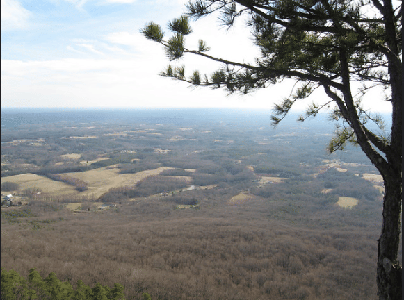
Continental Plateaus/ Plateaus of Accumulation
- Continental Plateaus are formed by either a large-scale continental uplift or the spread of horizontal basic lava sheets (less viscous) that entirely cover the previous landscape.
- In contrast to the neighboring plain or sea, this type of plateau has an abrupt rise (i.e. more steepness on the sides).
- Plateaus of Accumulation is another name for the Continental Plateaus.
- A good example of a continental plateau is Maharashtra's Plateau.
Dissected Plateaus
- A dissected plateau is one that has been significantly eroded, resulting in sharp relief. It is possible that such a region will appear to be mountainous.
- The upward migration of the Earth's crust results in the formation of a dissected plateau.
- The lack of folding, metamorphism, substantial faulting or magmatic activity that occurs with orogeny distinguishes dissected plateaus from orogenic mountain belts (mountain building).
- The steady clash of tectonic plates causes the uplift.
- Examples include the Colorado Plateau in the western United States, the Tibetan Plateau, and others.

Major Plateaus of the World
| Name | Loation | Description |
|---|---|---|
| Colorado Plateau | The United States |
|
| Tibetan Plateau | China |
|
| Deccan Plateau | India |
|
Plateaus - Economic Significance
- Storehouse of Minerals: Plateaus are where the majority of the world's minerals are found. In comparison to mountains, plateaus make it easier to extract minerals.
- Plateaus provide the majority of the raw materials used in industry. We obtain gold from the plateaus of Western Australia, Africa, and India. The Chottanagpur Plateau in India provides coal, iron, manganese, and mica.
- Hydel-Power Generation: Plateaus' waterfall-like edges provide for excellent locations for hydel power production.
- Cool Climate: Even in tropical and subtropical countries, the highest portions of plateaus have a cool climate.
- Agriculture & Animal Rearing: Plateaus feature expansive grassland areas ideal for raising livestock, particularly sheep, goats, and cattle. In comparison to other plateaus, the lava plateaus are richer in minerals and are used for agriculture since the soil is so fertile.
Conclusion
Plateaus may be found on every continent and cover a third of the planet's surface. Along with mountains, plains, and hills, they are one of the four primary landforms. India's Deccan plateau is one of the world's oldest plateaus. River water runs through the plateau, forming valleys. The Tibet plateau, which rises 4,000 to 6,000 meters above sea level, is the world's highest plateau. Plateaus have a lot of mineral resources, which makes them quite useful.
|
|
|
|---|---|
| Geography Notes | Physical Geography |
| Geomorphic Processes | Geomorphology |
| Lakes and Its Type | Minerals and Rocks |
| Endogenic Processes | Exogenic Processes |
FAQs
Question: What is a plateau?
Answer: A plateau is an elevated flat-topped landform that rises above the surrounding areas. It can form due to tectonic movements, volcanic activity, or erosion.
Question: What are tectonic plateaus?
Answer: Tectonic plateaus are formed due to the uplift of Earth's crust through tectonic forces, such as the Colorado Plateau and the Deccan Plateau.
Question: How are volcanic plateaus formed?
Answer: Volcanic plateaus are formed by lava flows from volcanic eruptions that accumulate to form extensive flat regions, like the Columbia Plateau.
Question: What is an intermontane plateau?
Answer: An intermontane plateau is a flat region located between mountain ranges, like the Tibetan Plateau.
Question: How are erosional plateaus formed?
Answer: Erosional plateaus are formed by the erosion of surrounding land, leaving behind a high-standing flat area, like the Scottish Highlands.
MCQs
1. Which type of plateau is formed due to volcanic activity?
A) Tectonic Plateau
B) Volcanic Plateau
C) Erosional Plateau
D) Dissected Plateau
Answer: (B) See the Explanation
Volcanic plateaus are formed by lava flows from volcanic eruptions that accumulate over time, creating a flat, elevated area.
2. Which of the following is an example of a tectonic plateau?
A) Columbia Plateau
B) Deccan Plateau
C) Tibetan Plateau
D) Ozark Plateau
Answer: (B) See the Explanation
The Deccan Plateau in India is an example of a tectonic plateau formed by the uplift of the Earth's crust.
3. Which plateau is an example of an intermontane plateau?
A) Tibetan Plateau
B) Scottish Highlands
C) Colorado Plateau
D) Ozark Plateau
Answer: (A) See the Explanation
The Tibetan Plateau is an intermontane plateau, located between mountain ranges like the Himalayas and Kunlun Mountains.
4. What causes the formation of dissected plateaus?
A) Volcanic eruptions
B) Uplift followed by river erosion
C) Accumulation of sediment
D) Glacial activity
Answer: (B) See the Explanation
Dissected plateaus form when a flat region is uplifted and then eroded by rivers, creating rugged terrain.
5. Which type of plateau is formed through erosional processes?
A) Dissected Plateau
B) Volcanic Plateau
C) Erosional Plateau
D) Tectonic Plateau
Answer: (C) See the Explanation
Erosional plateaus are formed when surrounding land is eroded, leaving a flat, high-standing region, like the Scottish Highlands.
GS Mains Questions and Model Answers
Q1: Discuss the formation and significance of tectonic plateaus.
Answer: Tectonic plateaus form when sections of the Earth's crust are uplifted due to tectonic forces. The Deccan Plateau in India and the Colorado Plateau in the USA are examples of tectonic plateaus. These plateaus are significant as they often contain rich mineral deposits, support agriculture, and have a unique climate that supports diverse ecosystems. Additionally, their elevation impacts weather patterns, making them crucial for regional climatic conditions.
Q2: Analyze the impact of volcanic plateaus on human settlements and agriculture.
Answer: Volcanic plateaus are formed by lava flows and often have fertile soils due to the mineral-rich nature of volcanic ash. This makes them ideal for agriculture, especially in regions like the Columbia Plateau. However, the proximity to volcanic activity can pose risks, such as potential eruptions or earthquakes, which can disrupt human settlements. Despite these risks, volcanic plateaus support large populations and play a crucial role in agriculture.
Q3: Explain the importance of intermontane plateaus like the Tibetan Plateau in global climate patterns.
Answer: The Tibetan Plateau is known as the "Roof of the World" due to its elevation. It plays a significant role in global climate patterns, particularly influencing the Asian monsoon. Its high altitude affects atmospheric circulation and weather patterns across Asia. The plateau also serves as a water source for many of the major rivers in Asia, making it crucial for the water supply in countries like China and India.
Previous Year Questions on Plateau
1. UPSC CSE Mains 2020 (GS Paper 1)
Question: Describe the formation and characteristics of volcanic plateaus.
Answer: Volcanic plateaus form as a result of repeated lava flows from volcanic eruptions. Over time, the layers of lava accumulate, forming a flat or gently sloping elevated region. Volcanic plateaus often have fertile soil, making them suitable for agriculture. The Columbia Plateau in the USA is an example of a volcanic plateau. These regions are also prone to volcanic activity and earthquakes, which can pose risks to human settlements.
2. UPSC CSE Prelims 2018
Question: Which of the following is an example of a tectonic plateau?
A) Colorado Plateau
B) Deccan Plateau
C) Scottish Highlands
D) Tibetan Plateau
Answer: B
The Deccan Plateau is an example of a tectonic plateau formed by the uplift of the Earth's crust, primarily due to tectonic activity.
Download the PREPP App and attempt FREE IAS Exam Mock Tests and get complete study material!

Full Test - 04: UPSC CSE Prelims CSAT (Paper-II)
Full Test - 03: UPSC CSE Prelims CSAT (Paper-II)
UPSC CSE Prelims 2026 GS Paper 1 Question Paper (24-May-2026)
UPSC CSE Prelims 2026 CSAT Paper 2 Question Paper (24-May-2026)

17 February 2025 | The Hindu Must Read Articles | Current Affairs

16 February 2026 | The Hindu Must Read Articles | Current Affairs

13 February 2026 | The Hindu Must Read Articles | Current Affairs









Comments