High In The Andes, Water Levels Fall To Historic Lows In Lake Titicaca
Relevance: GS3 - Conservation, environmental pollution and degradation, Disaster and disaster management GS1 - Geographical features and their location-changes in critical geographical features (including water-bodies and ice-caps) and in flora and fauna and the effects of such changes, Distribution of key natural resources across the world,
(Source: Times of India, 08/17/2023)
Click here for Daily Current Affairs
Why in the news?
- Recently, water levels in Lake Titicaca have dropped to within 10 inches of their record lows.
- The decreasing water level has been attributed to meteorological, hydrological, and climatic factors.
Table of Contents
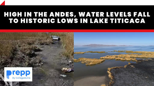
What has happened to Lake Titicaca?
- The lake's water level is currently within 25 centimeters of its all-time low which was recorded in 1992.
- In three months, the water has decreased by 30 centimeters.
- Experts have predicted that the water level will fall further due to the stronger radiation during the present season.
- The lake’s surface area, which measured around 3,200 square miles (8,300 square kilometers) , has shrunk significantly.
- However, the extent of the loss has not yet been assessed properly.
What are the main reasons for the decline in Lake Titicaca’s water level?
- Poor rainfall: According to the Bolivian weather agency, there is a severe deficit of rain in the region, which has severely reduced the level of water in the lake.
- The rainfall and the subsequent inflow to the lake from Peruvian rivers were not sufficient to generate the normal rises.
- El Nino and La Nina: The El Nino and La Nina phenomena which are associated with rains and droughts have been distorted in terms of their patterns and factors over time.
- El Niño is a natural climatic event that is generally associated with increased temperatures, droughts in some parts of the world, and heavy rains in others.
- La Niña causes the opposite effects particularly a drop in temperatures.
- Climate change: In the absence of sufficient rainfall, the evaporation rate of the lake increases as a result of the higher surface and air temperature.
- This has led to a fall in the water levels of the lake levels with experts suggesting the lake could lose up to 85% of its current volume even if warming is limited to under 2°C.
- Anthropological stress: It is heavily polluted by waste from El Alto, a city of one million people in Bolivia.
- Indiscriminate fishing has adversely affected aquatic species in the lake.
Impacts
- Biodiversity: More than 500 species of animals and plants are found in the lake, including endemic and endangered species.
- The falling water levels could threaten their existence and lead to the loss of important species.
- Human activities: The majority of people who live along the lake are fishermen and farmers.
- The lake is a vital part of the life of the rural communities that practice subsistence farming and livestock rearing.
- The drop in water levels has resulted in the shortage of plants that grow along the lakeside which are used as fodder by locals,
- The dropping water levels will also adversely impact tourism which is a major source of income for the region.
- Famine and poverty: The staple diet of rural communities includes fish, whose population is reducing due to a decline in water level.
- Harvests are also likely to fall due to the lack of water in the lake.
- Indirectly it could also lead to a rise in the prices of most ingredients.
- This poses a threat of famine and poverty due to the loss of traditional livelihoods.
- Migration: As a result of the loss of livelihood and increasing economic hardships due to the decline of water levels, people have begun to migrate out of the region
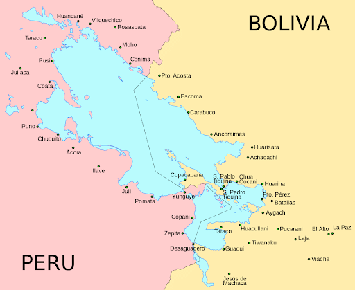
Lake Titicaca
- Lake Titicaca is the largest freshwater lake in South America.
- It is also known as the highest navigable lake in the world and the largest mountain lake in the world.
- Location: It is located on the northern point of the endorheic Altiplano basin of the Andes Mountains.
- It lies on the border between Peru and Bolivia.
- Size: It extends for 3,200 square miles and extends in a northwest-to-southeast direction for a distance of 190 km.
- Geographical features:
- It consists of two subbasins - Lake Huinaymarca (Bolivia) and Lake Pequeño (Peru) - which are separated by the Strait of Tiquina.
- The major river systems that feed the lake are the Ramis, Coata, Ilave, Huancané, and Suchez.
- Conservation:
- Ramsar Site since 1998.
- It has been included in the National System of Protected Areas (SINANPE) as a national reserve (IUCN VI category).
- Flora and Fauna:
- It is home to threatened species such as the Titicaca water frog, Titicaca grebe, Titicaca orestias, vizcacha, Andean fox,
- Reeds like totora and aquatic vegetation are widespread.
- It is famous for the Floating Islands, which are human-made islands constructed by the Uros people from layers of cut totora.
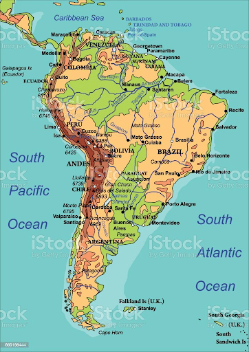
Andes
- The Andes is the longest above-water mountain range in the world (8,900 km) and is second behind the Himalayas in terms of average elevation.
- Formation: The Andes were created over 50 million years ago following the collision of the South American and Pacific tectonic plates.
- Extent:
- It spreads from the southern tip of South America to the northernmost coast of the Caribbean.
- The Andes Mountains extend over seven countries: Argentina, Bolivia, Chile, Colombia, Ecuador, Peru, and Venezuela.
- It is about 5,500 miles (8,900 km) long and second only to the Himalayas in average elevation.
- Terrain: It consists of parallel and transverse mountain ranges, or cordilleras, and intervening plateaus and depressions.
- Mount Aconcagua (Argentina), at 22,841 feet (6,962 m) above sea level is the highest peak in the Andes.
- It also houses the highest volcano when measured above sea level, i.e. the Ojos del Salado on the Chile-Argentina border.
- Climate:
- Annual precipitation is higher to the south of 40°S and diminishes and becomes seasonal to the north of 40°S.
- Temperature, atmospheric pressure, and humidity decrease in higher elevations.
- The southern Andes are rainy and cool, the central section is dry and the northern section is rainy and warm.
- Vegetation: Andean soils are relatively young.
- However, they are affected by the high level of erosion by water and winds because of the steep gradients of the land.
(*Click this link to read prelims specific weekly current affairs articles)
FAQs
Question: What is an endorheic basin?
Answer:
An Endorheic basin is a limited drainage basin that generally retains water and permits no outflow to external bodies of water, such as rivers or oceans. It is a closed hydrological system. Eg: the Caspian Sea, the Dead Sea, the Great Basin (North America), and some basins of the Altiplano plateau.
Question: What is a cordillera?
Answer:
A Cordillera is a collection of mountains that consists of ridges, ranges, mountain chains, and mountain systems. It is derived from a Spanish word meaning rope or chain. Eg: Andean cordillera, Western cordillera.
UPSC Mains Practice Question:
|
MCQs
Question: Which one of the following pairs is correctly matched? (UPSC CSE 2013)
Geographical Region Feature
(a) Abyssinian Plateau: Arabia
(b) Atlas Mountains: NorthWestern Africa
(c) Guiana Highlands: SouthWestern Africa
(d) Okavango Basin: Patagonia
Answer: (b) See the Explanation
- The Abyssinian Plateau is located in Ethiopia, Africa.
- The Atlas Mountains are located in Northwest Africa.
- The Guiana Highlands are located in the northern part of South America.
- The Okavango Basin is located in Southwestern Africa, not Patagonia which is in South America.
Therefore, option (b) is the correct answer.
Question: Which of the following are properly arranged from west to east?
(a) Erie - Titicaca - Victoria - Baikal
(b) Victoria - Titicaca - Baikal - Erie
(c) Baikal - Victoria - Titicaca - Erie
(d) Titicaca - Erie - Victoria - Baikal
Answer: (a) See the Explanation
- The correct order of the lakes from west to east is as follows:
- Lake Erie (81.2°W, North America) - Lake Titicaca (69.3°W, South America) - Lake Victoria (33.5°E, Africa) - Lake Baikal (108.1°E, Asia)
Therefore, option (a) is the correct answer.
Download the PREPP App and attempt FREE IAS Exam Mock Tests and get complete study material!

Full Test - 04: UPSC CSE Prelims CSAT (Paper-II)
Full Test - 03: UPSC CSE Prelims CSAT (Paper-II)
UPSC CSE Prelims 2026 GS Paper 1 Question Paper (24-May-2026)
UPSC CSE Prelims 2026 CSAT Paper 2 Question Paper (24-May-2026)

17 February 2025 | The Hindu Must Read Articles | Current Affairs

16 February 2026 | The Hindu Must Read Articles | Current Affairs

13 February 2026 | The Hindu Must Read Articles | Current Affairs









Comments