Philippines, Malaysia, Indonesia Protest China’s Map
Relevance: GS 2 - India and its neighborhood- relations; Effect of policies and politics of developed and developing countries on India’s interests, Indian diaspora.
(Source: The Hindu, 09/01/23)
Click here for Daily Current Affairs
Why in the news?
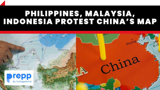
- Recently, the Philippines, Malaysia, and Indonesia released separate statements voicing their opposition to China’s new “standard map” for 2023, which has also drawn a strong protest from India.
- The map showed all of the Indian State of Arunachal Pradesh, Aksai Chin, as well as the entire South China Sea within China’s borders.
- China's issuance of new maps, which include disputed territories, has raised concerns among its neighbors. These maps are seen as complicating ongoing negotiations over territorial disputes.
Table of Contents
Countries Reject Chinese Standard Maps
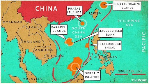
- Philippines: The Philippines' Foreign Ministry issued a statement rejecting China's 2023 version of the "standard map." They specifically object to the inclusion of the nine-dash line.
- The Philippines argues that this attempt by China to assert sovereignty and jurisdiction over Philippine features and maritime zones is not grounded in international law, particularly the United Nations Convention on the Law of the Sea (UNCLOS) from 1982.
- Malaysia: Malaysia's government also protested against China's map, rejecting it due to its inclusion of unilateral claims to Malaysian maritime territory, including parts of Malaysia's Exclusive Economic Zone (EEZ).
- Indonesia: Indonesia issued a statement emphasizing that any drawing of territorial lines, including those in China's 2023 Standard Map, should be in line with the UN Convention on the Law of the Sea (UNCLOS) from 1982.
What is the source of India-China tension?
- A Disputed Border and Shifting Dynamics: The primary source of tension lies in the ill-defined, 3,440 km-long border that divides the two nations.
- Rivers, lakes, and shifting snowcaps contribute to the changing demarcation, causing frequent face-offs between soldiers at various points.
- The ties between India and China were severely strained following the eastern Ladakh border row that began in May 2020.
- The Indian and Chinese troops are locked in an over three-year confrontation in specific friction points in eastern Ladakh even as the two sides completed disengagement from several areas following extensive diplomatic and military talks.
- Infrastructure: Both countries are also engaged in constructing infrastructure along the border, adding complexity to the situation. India's construction of a high-altitude air base road was a key trigger for a deadly clash in 2020.
- Confrontation: The 2020 Galwan Valley confrontation, where soldiers battled with rudimentary weapons, resulted in casualties on both sides, marking the first fatal clash since 1975. The use of firearms, previously prohibited by a 1996 agreement, occurred in 2021, heightening the danger.
Conclusion
- The issuance of new maps by China, especially with disputed territories, is viewed by its neighbors as a provocative and complicating factor in ongoing negotiations and territorial disputes.
- It can contribute to regional instability and hinder efforts to find peaceful resolutions to these disputes through diplomatic means.
Why is the South China Sea Important?
What are the disputes in the South China Sea?
Republic of Philippines v. People's Republic of China:Permanent Court of Arbitration
|
(*Click this link to read prelims specific weekly current affairs articles)
FAQs
Question: What is ASEAN?
Answer:
Association of Southeast Asian Nations is an international organization established by the governments of Indonesia, Malaysia, the Philippines, Singapore, and Thailand in 1967 to accelerate economic growth, social progress, and cultural development and to promote peace and security in Southeast Asia. Brunei joined in 1984, followed by Vietnam in 1995, Laos and Myanmar in 1997, and Cambodia in 1999.
Question: What is the Nine-dash Line?
Answer:
‘Nine-dash line’ is a dotted line that was adopted from Chinese maps in the 1940s, and represents Beijing’s claim over the sea and all the land features that are contained within the line.
Question: What is UNCLOS?
Answer:
The United Nations Convention on the Law of the Sea, also called the Law of the Sea Convention or the Law of the Sea Treaty, is an international agreement that establishes a legal framework for all marine and maritime activities.
UPSC Mains Practice Question:
|
MCQ
A similar question can be asked on the South China Sea
Question: Which one of the following countries of South-West Asia does not open out to the Mediterranean Sea? (UPSC- 2015)
(a) Syria
(b) Jordan
(c) Lebanon
(d) Israel
Answer: (b) See the Explanation
- The countries surrounding the Mediterranean in clockwise order are Spain, France, Monaco, Italy, Slovenia, Croatia, Bosnia and Herzegovina, Montenegro, Albania, Greece, Turkey, Syria, Lebanon, Israel, Palestine, Egypt, Libya, Tunisia, Algeria, and Morocco;
- Malta and Cyprus are island countries in the sea. In addition, Gibraltar, an overseas territory of the United Kingdom, is located on the coast of the Mediterranean.
- The drainage basin encompasses a large number of other countries, the Nile being the longest river ending in the Mediterranean Sea.
- Therefore, option (b) is the correct answer.
Download the PREPP App and attempt FREE IAS Exam Mock Tests and get complete study material!

Full Test - 04: UPSC CSE Prelims CSAT (Paper-II)
Full Test - 03: UPSC CSE Prelims CSAT (Paper-II)
UPSC CSE Prelims 2026 GS Paper 1 Question Paper (24-May-2026)
UPSC CSE Prelims 2026 CSAT Paper 2 Question Paper (24-May-2026)

17 February 2025 | The Hindu Must Read Articles | Current Affairs

16 February 2026 | The Hindu Must Read Articles | Current Affairs

13 February 2026 | The Hindu Must Read Articles | Current Affairs









Comments