
Which of the following statements is/are correct? 1. Visakhapatnam Port is a land- locked harbour. 2. Deendayal Port is a tidal port. Select the correct answer using the code given below.
Understanding Indian Ports: Visakhapatnam and Deendayal
This question asks us to evaluate the correctness of two statements regarding specific ports in India: Visakhapatnam Port and Deendayal Port.
Let's examine each statement carefully.
Analysing Statement 1: Visakhapatnam Port
Statement 1 says: "Visakhapatnam Port is a land-locked harbour."
Visakhapatnam Port is located on the east coast of India, in Andhra Pradesh. It is indeed known for being a natural harbour. The harbour is formed by a creek entering the sea, and it is protected by the Dolphin's Nose hill on one side and a sand spit on the other. This geographical feature provides shelter and makes it a relatively calm and protected harbour, often described as being land-locked by natural features, providing natural protection.
Therefore, Statement 1 appears to be correct.
Analysing Statement 2: Deendayal Port
Statement 2 says: "Deendayal Port is a tidal port."
Deendayal Port, formerly known as Kandla Port, is located in the Gulf of Kutch in Gujarat, on the west coast of India. The Gulf of Kutch region experiences a very high tidal range. Ports situated in areas with significant tidal variations often require special facilities or techniques to handle cargo and ships, making them tidal ports where operations are heavily influenced by the tides.
Deendayal Port is well-known as a tidal port because its operations are significantly affected by the rise and fall of tides in the Gulf of Kutch. It was developed specifically to handle the challenges posed by these high tides.
Therefore, Statement 2 also appears to be correct.
Comparing the Statements and Options
Based on our analysis, both Statement 1 (Visakhapatnam Port being a land-locked harbour) and Statement 2 (Deendayal Port being a tidal port) appear to be correct statements about these Indian ports.
Let's look at the options provided:
- 1. 1 only
- 2. 2 only
- 3. Both 1 and 2
- 4. Neither 1 nor 2
Since both statements are correct, the option that selects "Both 1 and 2" would be the correct choice.
| Statement | Assessment | Reasoning |
|---|---|---|
| 1. Visakhapatnam Port is a land- locked harbour. | Correct | Visakhapatnam Port is a natural harbour well-protected by geographical features, often described as land-locked. |
| 2. Deendayal Port is a tidal port. | Correct | Deendayal Port (Kandla) is located in the Gulf of Kutch, known for high tides, and its operations are tide-dependent. |
Conclusion on Indian Ports
Both statements accurately describe characteristics of Visakhapatnam Port and Deendayal Port. Visakhapatnam Port is known for its land-locked nature due to natural protection, and Deendayal Port is a prominent example of a tidal port in India due to its location and tidal range.
Revision Table: Key Facts on Ports
| Port | Location | Key Characteristic |
|---|---|---|
| Visakhapatnam Port | Andhra Pradesh (East Coast) | Natural, Land-locked harbour (protected by hills/features) |
| Deendayal Port (Kandla) | Gujarat (West Coast, Gulf of Kutch) | Tidal Port (operations influenced by high tides) |
Additional Information on Port Types
Understanding different types of ports and harbours is important for geography and economic studies. Here are a few related concepts:
- Natural Harbour: A harbour created by natural features of the coastline, such as bays, inlets, or estuaries, that provide shelter from waves and currents. Visakhapatnam is an example.
- Artificial Harbour: A harbour constructed by building breakwaters, jetties, or dredging to create a protected area for ships.
- Tidal Port: A port located in an area with a large tidal range where the water depth fluctuates significantly with the tides. Operations might require special docks (like lock gates) or scheduling around high tide. Deendayal Port is a prime example in India.
- Land-locked Harbour: This term is often used to describe a harbour that is surrounded or protected by land or geographical features on most sides, offering significant shelter. While Visakhapatnam is on the coast, its specific natural features make this description applicable.
Similar Questions
What is Inter-cropping?
As per Census 2011, the concentration of Scheduled Caste population (going by percentage of Scheduled Caste population to total population of the State) is the highest in the State of _________.
What do you mean by 'Demographic Dividend'?
Consider the following statements with respect to the adolescent population (age group of 10 to 19 years) of India, according to the 2011 Census :
1. Adolescent population comprises half the population of the country.
2. The group is regarded as youthful population with high potential.
3. In this group there are greater number of females than males.
Which of the statements given above is/are correct?
According to the Census 2011, in India, what is the percentage of people (approximately) considered to be migrants (internal), i.e., now settled in a place different from their previous residence?
On which among the following is National Waterway No. 2 situated?
Which of the the following statements regarding coconut production in Lakshadweep is/are correct?
1. Productivity per hectare is highest in India.
2. Oil content in nuts is highest in the world.
Select the correct answer using the code given below.
What is culturable wasteland?
According to Census 2011, which one of the following is the correct sequence of stages in decreasing order of their total size of the population?
Consider the following map of India:
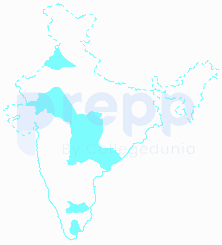
The areas marked in the map given above account for the production of which one of the following cash crops?
Important Questions from Indian Economic and Human Geography
In India, oil wells are found in:
Which of the following is a non-Conventional source of energy?
Select the top Four States with highest population according to census 2011
In which of the following district Manganese is found ?
Monu went on a trip, when he return back he told his classmates that he travelled the longest National Highway of India. You have to tell on which of the following tour he was ?



