
On which among the following is National Waterway No. 2 situated?
The Brahmaputra, Sadiya-Dhubri
Understanding National Waterway No. 2 Location
The question asks to identify the specific river system and route where National Waterway No. 2 is located. Understanding India's designated national waterways is crucial for geography and transportation studies.
Identifying National Waterway Routes
India has a network of designated National Waterways (NWs) managed by the Inland Waterways Authority of India (IWAI). Each NW is defined by a specific river, river system, or canal stretch. Let's examine the options provided in relation to the known routes:
- Option 1: The Ganga, Haldia-Prayagraj - This route corresponds to National Waterway No. 1 (NW-1), which is the longest waterway on the Ganga, Bhagirathi, and Hooghly rivers.
- Option 2: West Coast Canal, Kottapuram- Kollam - This route is designated as National Waterway No. 3 (NW-3), located in Kerala.
- Option 3: The Brahmaputra, Sadiya-Dhubri - This is the correct designation for National Waterway No. 2 (NW-2). It runs along the Brahmaputra River in Assam.
- Option 4: Godavari and Krishna, Kakinada- Puducherry - This stretch forms part of National Waterway No. 4 (NW-4), connecting Andhra Pradesh and Puducherry via the Godavari and Krishna delta systems.
Details of National Waterway No. 2
National Waterway No. 2 (NW-2) is a vital navigable waterway in Northeast India. It follows the course of the mighty Brahmaputra River. The specific stretch designated for NW-2 is from Sadiya to Dhubri in the state of Assam. This waterway plays a significant role in the transportation of goods and passengers in the region, connecting important towns and cities along the river.
Conclusion on NW-2
Based on the official designations of India's National Waterways, the route described as The Brahmaputra, Sadiya-Dhubri accurately represents National Waterway No. 2.
Similar Questions
What is Inter-cropping?
As per Census 2011, the concentration of Scheduled Caste population (going by percentage of Scheduled Caste population to total population of the State) is the highest in the State of _________.
What do you mean by 'Demographic Dividend'?
Consider the following statements with respect to the adolescent population (age group of 10 to 19 years) of India, according to the 2011 Census :
1. Adolescent population comprises half the population of the country.
2. The group is regarded as youthful population with high potential.
3. In this group there are greater number of females than males.
Which of the statements given above is/are correct?
According to the Census 2011, in India, what is the percentage of people (approximately) considered to be migrants (internal), i.e., now settled in a place different from their previous residence?
Which of the the following statements regarding coconut production in Lakshadweep is/are correct?
1. Productivity per hectare is highest in India.
2. Oil content in nuts is highest in the world.
Select the correct answer using the code given below.
What is culturable wasteland?
According to Census 2011, which one of the following is the correct sequence of stages in decreasing order of their total size of the population?
Consider the following map of India:
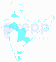
The areas marked in the map given above account for the production of which one of the following cash crops?
Headquarters of which one among the following Railway Zones in India is situated at the highest elevation from the mean sea level?
Important Questions from Indian Economic and Human Geography
Which of the following Indian states has the greatest number of sugar mills?
India possesses an expansive and continuously growing road network, vital for its economic and social development. When considering the cumulative length of national highways, state highways, and other categories of roads, India's road system is surpassed in total length by only one other country globally. What is India's rank in the world in terms of its total road network length?
According to the 2011 Census of India, which state has lowest population density?
In India, oil wells are found in:
Which of the following is a non-Conventional source of energy?



