
Consider the following map of India: The areas marked in the map given above account for the production of which one of the following cash crops?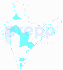
Cotton
Correct option- (a)
Crop | Soil | The Major Production States in India |
Cotton | Black Soil | Tamil Nadu, Gujarat, Karnataka, Telangana, Maharashtra, Rajasthan, and Madhya Pradesh. |
Groundnut | Sandy loam soil | Maharashtra, Rajasthan, Orissa, Madhya Pradesh, Uttar Pradesh, and West Bengal. |
Sugarcane | Sandy, loamy, and clay soils | Uttar Pradesh, Maharashtra, Bihar, Haryana, Karnataka, Tamil Nadu, Gujrat, Andhra Pradesh and Punjab. |
Tobacco | Sandy clay loam soil | Andhra Pradesh, Telangana, Karnataka, Gujarat, Maharashtra, Bihar, Tamil Nadu and West Bengal. |
Similar Questions
What is Inter-cropping?
As per Census 2011, the concentration of Scheduled Caste population (going by percentage of Scheduled Caste population to total population of the State) is the highest in the State of _________.
What do you mean by 'Demographic Dividend'?
Consider the following statements with respect to the adolescent population (age group of 10 to 19 years) of India, according to the 2011 Census :
1. Adolescent population comprises half the population of the country.
2. The group is regarded as youthful population with high potential.
3. In this group there are greater number of females than males.
Which of the statements given above is/are correct?
According to the Census 2011, in India, what is the percentage of people (approximately) considered to be migrants (internal), i.e., now settled in a place different from their previous residence?
On which among the following is National Waterway No. 2 situated?
Which of the the following statements regarding coconut production in Lakshadweep is/are correct?
1. Productivity per hectare is highest in India.
2. Oil content in nuts is highest in the world.
Select the correct answer using the code given below.
What is culturable wasteland?
According to Census 2011, which one of the following is the correct sequence of stages in decreasing order of their total size of the population?
Headquarters of which one among the following Railway Zones in India is situated at the highest elevation from the mean sea level?
Important Questions from Indian Economic and Human Geography
Which of the following Indian states has the greatest number of sugar mills?
India possesses an expansive and continuously growing road network, vital for its economic and social development. When considering the cumulative length of national highways, state highways, and other categories of roads, India's road system is surpassed in total length by only one other country globally. What is India's rank in the world in terms of its total road network length?
According to the 2011 Census of India, which state has lowest population density?
In India, oil wells are found in:
Which of the following is a non-Conventional source of energy?



