
Match List-I with List-II and select the correct answer using the code given below the Lists : List-I (Type of Land) List-II (Meaning) A. Urvara 1. Land watered by a river B. Maru 2. Fertile land C. Nadimatrika 3. Land watered by rain D. Devamatrika 4. Desert land
A-2, B-4, C-1, D-3
Matching Ancient Land Types and Meanings
This question asks us to match different types of land, as described in List-I, with their corresponding meanings provided in List-II. Understanding these terms helps in grasping historical land classifications.
Let's analyze each term and its meaning:
| List-I (Type of Land) | List-II (Meaning) |
|---|---|
| A. Urvara | 1. Land watered by a river |
| B. Maru | 2. Fertile land |
| C. Nadimatrika | 3. Land watered by rain |
| D. Devamatrika | 4. Desert land |
Based on historical classifications and interpretations of these terms:
- Urvara: This term generally refers to fertile land, suitable for cultivation.
- Maru: This term typically means desert or arid land, unsuitable for extensive cultivation.
- Nadimatrika: This term combines 'nadi' (river) and 'matrika' (mother), meaning land that is watered or nourished by a river. Such land is dependent on rivers for irrigation.
- Devamatrika: This term combines 'deva' (god, referring to rain god Indra) and 'matrika' (mother), meaning land that is watered or nourished by rain. Such land is dependent on rainfall for cultivation.
Now, let's match List-I with List-II based on these meanings:
- A. Urvara matches with 2. Fertile land.
- B. Maru matches with 4. Desert land.
- C. Nadimatrika matches with 1. Land watered by a river.
- D. Devamatrika matches with 3. Land watered by rain.
Combining these matches, we get the sequence A-2, B-4, C-1, D-3.
Revision Table: Land Types and Meanings
| Land Type (List-I) | Meaning (List-II) | Explanation |
|---|---|---|
| Urvara | Fertile land | Suitable for agriculture, productive soil. |
| Maru | Desert land | Arid or semi-arid region, poor soil, low productivity. |
| Nadimatrika | Land watered by a river | Cultivation dependent on river water (irrigation or natural flooding). |
| Devamatrika | Land watered by rain | Cultivation dependent primarily on rainfall. |
Additional Information on Land Classification
Historically, land was classified based on its productivity, water sources, and usage. These classifications were important for administration, revenue collection, and planning agricultural activities. Different texts and periods might have slightly varying terms or classifications, but the fundamental idea was to distinguish between land types based on their suitability for farming and dependence on water sources like rivers or rain.
- Importance of Water Sources: The distinction between 'Nadimatrika' and 'Devamatrika' highlights the critical role of water in ancient agriculture. Areas with reliable river water were often considered more secure for farming than those relying solely on the often unpredictable monsoon rains.
- Productivity Classification: 'Urvara' and 'Maru' represent the extremes of land productivity – fertile versus barren, directly impacting the potential for food production and settlement.
- Historical Context: These terms appear in various ancient Indian texts, including those related to economics, administration, and geography, indicating the importance of land management in the past.
Similar Questions
What is Inter-cropping?
As per Census 2011, the concentration of Scheduled Caste population (going by percentage of Scheduled Caste population to total population of the State) is the highest in the State of _________.
What do you mean by 'Demographic Dividend'?
Consider the following statements with respect to the adolescent population (age group of 10 to 19 years) of India, according to the 2011 Census :
1. Adolescent population comprises half the population of the country.
2. The group is regarded as youthful population with high potential.
3. In this group there are greater number of females than males.
Which of the statements given above is/are correct?
According to the Census 2011, in India, what is the percentage of people (approximately) considered to be migrants (internal), i.e., now settled in a place different from their previous residence?
On which among the following is National Waterway No. 2 situated?
Which of the the following statements regarding coconut production in Lakshadweep is/are correct?
1. Productivity per hectare is highest in India.
2. Oil content in nuts is highest in the world.
Select the correct answer using the code given below.
What is culturable wasteland?
According to Census 2011, which one of the following is the correct sequence of stages in decreasing order of their total size of the population?
Consider the following map of India:
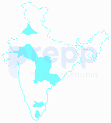
The areas marked in the map given above account for the production of which one of the following cash crops?
Important Questions from Indian Economic and Human Geography
In India, oil wells are found in:
Which of the following is a non-Conventional source of energy?
Select the top Four States with highest population according to census 2011
In which of the following district Manganese is found ?
Monu went on a trip, when he return back he told his classmates that he travelled the longest National Highway of India. You have to tell on which of the following tour he was ?



