Running Water as Geomorphological Agent - Geography Notes
Running water is the most important geomorphic agent, actively changing landforms through erosion and sediment transfer. The earth's surface is shaped by attrition, vertical and lateral erosion, and deposition. Running water is the most prevalent extrinsic process on this planet earth, especially in humid areas. This article will explain Running Water as Geomorphological Agent in detail, which will be quite useful for individuals taking the IAS Exam.
|
Table of Contents |
How Does Running Water Act as a Geomorphological Agent?
- Running water has a lot of energy. More erosion is caused by running water than by wind, gravity, or glaciers.
- Running water is the most important geomorphic agent, actively changing landforms by eroding and transferring sediments.
- It shapes the earth's surface by attrition, vertical and lateral erosion, and deposition.
- There are two components of running water.
- One is an overland flow on the general land surface as a sheet.
- Another is linear flow as streams and rivers in valleys.
- Soil and rock erosion are caused by moving water.
- Moving water carries rock and soil fragments and deposits them in new locations.
- It transports rocks and soil from the tops of mountains to flat regions.
- Running water is primarily responsible for various landforms in humid as well as dry climates.
Various Landforms
In humid climates, various landforms are created which can broadly be divided into two categories:
Erosional Landforms
- Overland flow transports soil particles downslope, causing erosion.
- Weathering and erosion provide the river with this rock material, which constitutes the river's load.
- This load acts as the grinding tool and aids in cutting the bottom and sides of the river bed.
- The river channel will be deepened and widened as a result.
- River erosion can be accomplished in four different ways, all of which function together.
- These are the four methods:
Corrosion or Abrasion
- It is in which rock fragments are broken off as the rock particles bounce, scrape, and drag down the river's bottom and sides.
- This is the mechanical grinding of the rivers against the banks and bed of the river.
- Corrosion can occur in one of two ways:
- Lateral Corrasion: This is a type of erosion that widens the river valley laterally.
- Vertical Corrasion: This is the downward erosion that deepens the valley of the river
Corrosion or Solutions
- It is water's chemical or solvent activity on soluble or partially soluble rocks with which river water comes into contact.
- Example- When limestone, or calcium carbonate, comes into contact with water, it dissolves quickly and is easily removed.
Hydraulic Action
- This is the process of material being mechanically loosened and swept away by the sheer power of river water.
- This technique does not include any load or material.
- Some amount of water splashes against the riverbanks, seeping into the cracks and fissures.
- It erodes the soft rocks it comes into touch with, picks up the loose fragments from its bank and bed, and transports them away.
Attrition
- This is the wear and tear caused by the carried materials colliding and rolling against one another.
- The coarser rocks are broken down into smaller bits during this process.
- To make pebbles, the angular edges are smoothed and softened.
Valleys, Gorges, Canyon
- A river valley is a large dip in the earth through which a stream travels during its entire course.
- The valley takes on distinct features at different periods of the erosional cycle.
- Valleys begin as a series of short, narrow rills. The rills will eventually become long, wide gullies.
- Valleys will form as the gullies continue to deepen, spread, and stretch.
- Many sorts of valleys can be identified based on the proportions, shape, types, and structure of the rocks in which they are formed, such as V-shaped valleys, gorges, canyons, and so on.
- The river is very swift as it descends the steep slope, and the predominant action of the river is vertical corrosion.
- The valley developed is thus deep, narrow, and distinctly V-shaped.
- A gorge is a narrow, deep valley with steep to straight sides.
- The breadth of a gorge is about equal at the top and bottom.
- Gorges are formed by the erosion of hard rocks. For instance, the Indus Gorge in Kashmir.
- A gorge is a variation of a canyon.
- A canyon, unlike a gorge, is broader at the top than it is at the bottom.
- The steep, step-like side slopes of a canyon define it.
- Canyons are most typically formed in sedimentary rocks that are horizontally bedded.
- For instance, the Colorado River carved the Grand Canyon in the United States.

River Terraces
- It's a type of surface that marks the former valley floor or flood plain.
- They are essentially the product of the stream's vertical erosion.
- Paired terraces are formed when the terraces on both sides of the river are of the same elevation.
- Unpaired terraces are those that have only one terrace on one side and none on the other, or one that is at a very different height on the other side.

Potholes and Plunge Pools
- Potholes are depressions in the stony beds of highland streams that are more or less round in shape.
- Pebbles and rocks accumulate in small, shallow depressions, which are rotated by flowing water.
- As a result, the depressions expand in size, becoming potholes.
- Plunge pools are big, deep potholes that are usually seen at the base of waterfalls.
- They're created by the sheer force of water and the rotation of boulders.
- Potholes are more or less circular depressions created by stream erosion aided by the abrasion of rock pieces over the rocky beds of hill-streams.
- Once a small, shallow depression occurs, pebbles and boulders collect in the depressions, which are then rotated by flowing water, causing the depressions to expand in size.
- Such depressions eventually unite, causing the stream valley to deepen.
- Large potholes, both deep and wide, emerge at the base of waterfalls because of the sheer impact of water and the rotation of stones.
- The deepening of valleys is also aided by these ponds.

Incised or Entrenched Meanders
- They're wide, deep meanders (loop-like channels) etched through unyielding rocks.
- They deepen and widen with time, forming gorges or canyons in hard rock.
- A typical meander differs from an incised/entrenched meander in that the latter is found on hard rocks.

Transportation
- Rivers transport rock fragments from one location to another.
- This activity is known as the transportation of load by a river.
- The load is moved in four different ways.
Traction
- The river's movement forces the heavier and larger rock particles, such as gravel and pebbles, to roll along its bed.
- These particles can be seen rolling, slipping, bumping, and being dragged.
- This process is known as traction and the load is termed as traction load.
Saltation
- Some rock particles move over a stream's bed by jumping or sliding or continuously bouncing. This is referred to as saltation.
Suspension
- Suspension is the process of water holding microscopic particles like sand, silt, and mud in suspension as the stream runs.
Solution
- Some rock particles disintegrate in river water and are thus transported.
Depositional Landforms
- The stream's slope becomes gentler as it descends from the hills to the plains. This lowers the stream's energy.
- Transportation is hampered by the decrease in energy, and as a result, a portion of the load begins to settle down.
- This phenomenon is known as deposition.
- Deposition occurs as a result of a change in slope or a decrease in the volume or velocity of river water.
- Most deposition occurs in plains and low-lying areas.
- When a river empties into a lake or sea, it dumps its entire load.
Alluvial Fans
- It's a type of surface that marks the former valley floor or flood plain.
- They are essentially the product of the stream's vertical erosion.
- Paired terraces are formed when the terraces on both sides of the river are of the same elevation.
- Unpaired terraces are those that have only one terrace on one side and none on the other, or one that is at a very different height on the other side.

Deltas
- Deltas are similar to alluvial fans, although they form in different places.
- They are discovered at the river's mouth, which is where the river's depositional activity ends.
- Unlike alluvial fans, the deposits that makeup deltas are well-sorted and stratified.
- The coarser material settles first, while finer elements such as silt and clay are carried out to sea.

Flood Plains and Natural Levees
- Deposition creates flood plains in the same way that erosion creates valleys.
- The active flood plain is a riverbed consisting of river deposits, whereas the inactive floodplain is the flood plain above the river's bank.
- Along the banks of big rivers, natural levees can be discovered.
- Low, linear, and parallel ridges of coarse deposits run parallel to the river's banks.
- The deposits on the levees are coarser than those distributed by floodwaters distant from the river.
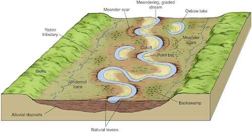
Meanders and Oxbow Lakes
- Meanders are loop-like channel patterns that form over the flood and delta plains.
- They are a type of channel pattern produced as a result of deposition rather than a landform.
- They are generated mostly due to three factors:
- the tendency of water running over a gentle gradient to work laterally on the banks
- the unconsolidated nature of the alluvial deposits that make up the bank, which have many irregularities; and
- the Coriolis force acts on fluid water, which deflects it like the wind.
- Cut-off bank refers to the concave bank of a meander, while slip-off refers to the convex bank.
- As meanders develop into deep loops, erosion at the inflection point may cut them off, resulting in oxbow lakes.

Braided Channels
- When a central bar is formed by the selective deposition of coarser materials, the river flow is diverted towards the banks, increasing lateral erosion.
- Braided channels are generated as more and more of these core bars are formed.
- Braided waterways give rise to riverine islands.

Significance
- Despite being in an arid climate, running water is still the most important external agent for landform development in deserts.
- In arid areas (mainly deserts) though rare, the precipitation is intense in its effect on the lightly vegetated cover, producing abrupt runoff.
- Great volumes of sediment can be moved in a very short time. Deposition goes a short distance, waiting for the next rain to move it further.
- Slight but sudden precipitation forms the terrain, creating deep canyons and dry steep valleys called Vadiya.
- Water carries large amounts of sediment into vegetation-free landscapes to stop erosion, creating sedimentary bayadas and vast peneplains.
- Also in arid regions of the Deccan plateau especially regions of basaltic lava cover in Maharashtra, rivers have been able to carve out deep valleys, inter stream tracks resembling highlands or chains of mountains.
- Examples: Balaghat, Satmala, Ajanta, etc. are formed. Similarly deep canyons in California are formed.
Conclusion
Running water is by far the most dominating geomorphic agent in shaping the earth’s surface in humid as well as arid climates. Running water in humid climates is essential and is received by heavy rainfall since it degrades the land surface. In arid climates, sudden torrential downpours lead to subsequent high-velocity floods which literally change the geomorphological features of the land. Thus the deep valleys, gorges, canyons, potholes, meanders, grooves, peneplain, and river terraces are all formations due to the erosional and depositional properties of running water.
|
|
|
|---|---|
| Geography Notes | Physical Geography |
| Geomorphic Processes | Geomorphology |
| Geomorphological agents | Minerals and Rocks |
| Endogenic Processes | Exogenic Processes |
FAQs
Q1: What is meant by running water as a geomorphological agent?
Answer: Running water refers to the continuous movement of water in streams and rivers, which shapes and modifies the landscape through erosion, transportation, and deposition.
Q2: How does running water contribute to erosion?
Answer: Running water erodes landscapes by removing soil and rock material, particularly in areas with steep gradients, leading to the formation of valleys and canyons.
Q3: What are the stages of river development influenced by running water?
Answer: The stages include youthful, mature, and old age, each characterized by different landforms such as v-shaped valleys, floodplains, and delta formations.
Q4: What is the role of running water in sediment transportation?
Answer: Running water transports sediments from one location to another, contributing to landform changes and the creation of sedimentary deposits in riverbeds and deltas.
Q5: How do human activities affect running water as a geomorphological agent?
Answer: Human activities, such as deforestation and urbanization, can increase runoff and sedimentation, altering natural water flow patterns and geomorphological processes.
MCQs
- What primary process does running water perform as a geomorphological agent?
A) Vegetation growth
B) Erosion
C) Soil fertility
D) Weathering
Answer: B) See the Explanation
Running water primarily erodes the landscape, shaping valleys and other landforms through the removal of soil and rock.
- Which of the following is a feature formed by the action of running water?
A) Cliff
B) Delta
C) Cave
D) Mountain
Answer: B) See the Explanation
Deltas are formed at river mouths where running water deposits sediments, creating new landforms.
- What is the impact of increased runoff due to urbanization on running water?
A) Decreased erosion
B) Increased sedimentation
C) Reduced water flow
D) Enhanced vegetation growth
Answer: B) See the Explanation
Urbanization often leads to increased runoff, resulting in more sediment being transported and deposited by running water.
- In which stage of river development do v-shaped valleys typically occur?
A) Old age
B) Mature
C) Youthful
D) Transitional
Answer: C) See the Explanation
V-shaped valleys are characteristic of the youthful stage, where rivers are steep and actively eroding the landscape.
- How does running water contribute to the formation of floodplains?
A) By lifting soil
B) By depositing sediments
C) By evaporating water
D) By increasing rainfall
Answer: B) See the Explanation
Floodplains are formed when running water overflows its banks, depositing sediments during floods.
GS Mains Questions and Model Answers
Q1: Discuss the geomorphological impact of running water on landscape formation.
Answer: Running water is a powerful geomorphological agent that shapes landscapes through erosion, transportation, and deposition. It carves valleys and canyons, transports sediments downstream, and creates various landforms such as deltas and floodplains. The process begins with erosion, where water removes soil and rock from high elevations, transporting these materials to lower areas. Over time, as water slows down, it deposits sediments, forming fertile plains and new landforms. This continuous process is vital in maintaining ecological balance and supporting biodiversity.
Q2: Analyze the role of running water in sediment transportation and deposition.
Answer: Running water plays a crucial role in sediment transportation and deposition, which are fundamental processes in geomorphology. As water flows over land, it picks up and carries sediment particles, ranging from fine silt to larger rocks. This transport occurs through mechanisms like suspension, saltation, and traction. When the water flow slows down, such as in river bends or at its mouth, sediments are deposited, leading to the formation of features like bars, deltas, and floodplains. This process not only shapes the landscape but also impacts soil fertility and aquatic habitats.
Q3: Evaluate the effects of anthropogenic activities on the geomorphological processes of running water.
Answer: Anthropogenic activities significantly influence the geomorphological processes associated with running water. Urbanization increases impervious surfaces, leading to enhanced runoff and altered natural drainage patterns. Deforestation can exacerbate erosion by removing vegetation that stabilizes soil, resulting in greater sediment transport. Additionally, construction activities may obstruct natural waterways, affecting their flow and leading to sedimentation in unwanted areas. These changes can disrupt ecosystems, increase flood risks, and alter the landscape, demonstrating the need for sustainable management practices to mitigate negative impacts.
Previous Year Questions on Running Water
1. UPSC Prelims 2020
Question: What role does running water play in shaping landforms?
Answer: Running water acts as a key geomorphological agent, shaping landforms through processes of erosion, transportation, and deposition. It carves valleys, transports sediments, and creates features like deltas and floodplains, reflecting its significant impact on the landscape.
2. UPSC Mains 2019
Question: Discuss how anthropogenic activities influence the geomorphological processes of running water.
Answer: Anthropogenic activities, including urbanization, deforestation, and industrialization, profoundly influence the geomorphological processes of running water. Urbanization leads to increased impervious surfaces, enhancing runoff and sedimentation in rivers. Deforestation reduces soil stability, increasing erosion and sediment transport. Furthermore, construction projects can alter natural water flow and disrupt sediment deposition patterns, leading to environmental degradation and increased flood risks. Effective management strategies are essential to mitigate these impacts and preserve the natural geomorphological processes.
Download the PREPP App and attempt FREE IAS Exam Mock Tests and get complete study material!
UPSC IAS : CSAT - Mini Live Test

Live Test : UPSC CSE Prelims CSAT (Paper-II) (Oct 20 - 23)
Full Test - 04: UPSC CSE Prelims CSAT (Paper-II)
Full Test - 03: UPSC CSE Prelims CSAT (Paper-II)
UPSC CSE Prelims 2026 GS Paper 1 Question Paper (24-May-2026)
UPSC CSE Prelims 2026 CSAT Paper 2 Question Paper (24-May-2026)

17 February 2025 | The Hindu Must Read Articles | Current Affairs

16 February 2026 | The Hindu Must Read Articles | Current Affairs

13 February 2026 | The Hindu Must Read Articles | Current Affairs









Comments