Mahanadi - River Systems in Peninsular India - Geography Notes
The Mahanadi River is a significant river in East-Central India. It drains approximately 132,100 square kilometres and has a total length of 900 kilometres. The Hirakud Dam is also located in Mahanadi. Mahanadi River flows through Chhattisgarh and Odisha before joining the Bay of Bengal. The Mahanadi, like many other seasonal Indian rivers, is a confluence of several Himalayan streams, making its specific source challenging to locate. This article will explain to you about the Mahanadi which will be helpful in Geography preparation for the UPSC Civil service exam.
|
Table of Contents |
Mahanadi River
- The Mahanadi basin drains an area of 1.4 lakh square kilometres and spans the states of Chhattisgarh and Odisha, as well as minor areas of Jharkhand, Maharashtra, and Madhya Pradesh.
- It is flanked on the north by the Central India hills, on the south and east by the Eastern Ghats, and on the west by the Maikala range.
- The Mahanadi ("Great River") has a total length of 560 miles (900 km).
- Its source is located at an elevation of 442 metres in the northern foothills of Dandakaranya in the Raipur District of Chhattisgarh.
- The Mahanadi is one of the principal rivers of the peninsular rivers, ranking second only to the Godavari in terms of water potential and flood-producing capability.
- Other small streams between the Mahanadi and the Rushikulya that feed straight into Chilka Lake are also included in the basin.
- The majority of the basin is covered by agricultural land, which accounts for 54.27 percent of the total area.
- It is one of the Indian subcontinent's most active silt-depositing streams.
- It goes east after receiving the Seonath River and enters Odisha state.
- At Sambalpur, the Hirakud Dam (one of India's largest dams) on the river has created a man-made lake 35 miles (55 kilometres) long.
- It flows via many waterways in the Odisha lowlands near Cuttack before entering the Bay of Bengal at False Point.
- Puri, near one of its mouths, is a well-known pilgrimage destination.
- The Mahanadi main canal and Tandula reservoir in Chhattisgarh were two key projects constructed during the pre-plan period in the basin.
- The Hirakud dam, Mahanadi delta project, Hasdeo Bango, and Mahanadi Reservoir Project were completed during the planning phase.
- The delta portion of the basin is vulnerable to severe floods on occasion due to the waterways' insufficient carrying capacity.
- By holding some flood water, the multi-purpose Hirakud dam provides some flood relief.
- However, the problem remains, necessitating the development of a long-term remedy.

Mahanadi River
|
|
|
|---|---|
| Peninsular Drainage | River Systems in Peninsular India |
| Narmada | Godavari |
| Tapi | Krishna |
| Cauvery | River Systems of Himalayan Drainage |
Tributaries of Mahanadi
- Its upper stream is located in the 'Chhattisgarh Plain,' a saucer-shaped basin.
- Due to the number of tributaries entering the main river from these directions.
- The Seonath, Hasdeo, Mand, and Ib are all left bank tributaries.
- The Ong, Tel, and Jonk are right bank tributaries.
Industries in Mahanadi River Basin
- Raipur, Durg, and Cuttack are three prominent urban centres in the basin.
- The Mahanadi basin has a good industrial climate due to its abundant natural resources and ample electricity supply.
- The iron and steel plant at Bhilai, the aluminium plants at Hirakud and Korba, the paper mill in Cuttack, and the cement factory at Sundargarh are among the important enterprises now operating in the basin.
- Sugar and textile mills are two more businesses that rely heavily on agricultural products.
- Other industrial activities include coal, iron, and manganese mining.
- Paradip Port is a deep-water natural port on India's east coast. It's located at the confluence of the Mahanadi and the Bay of Bengal.
Mahanadi River Basin
- The basin's catchment area includes large areas of Chhattisgarh and Odisha, as well as lesser portions of Jharkhand, Maharashtra, and Madhya Pradesh.
- The Mahanadi basin is subdivided into three subbasins: upper, middle, and lower Mahanadi.
- The basin is formed like a saucer and is largely located in the state of Chhattisgarh.
- The basin is circular in shape, with a circumference of around 400 kilometres and an exit passage of roughly 160 kilometres in length and 60 kilometres in width.
- The basin is separated into four physiographic regions: the northern plateau, the Eastern Ghats, the coastal plain, and the central table land and erosional plains.
- Deltaic soil may be found in the Mahanadi's coastal plains.
- The principal soils found in the basin's Chhattisgarh region are black soil and sandy soil with "Kankar."
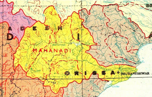
Mahanadi River Basin
Conclusion
Peninsular India's Mahanadi River is one of the country's major east-flowing rivers. Among peninsular rivers, the Mahanadi comes second to the Godavari in terms of water potential. The Mahanadi was navigable prior to the building of the Hirakud Dam. The Mahanadi River system is Peninsular India's third-biggest river system and Odisha's major river. Mahanadi is a combination of the Sanskrit words maha, which means "great," and nadi, which means "river."
|
|
|
|---|---|
| Geography Notes | Physical Geography |
| River Basins in India | Major Lakes in India |
| Indian Drainage Systems | India's Major Rock Groups |
| Smaller Rivers of India flowing towards West | Smaller Rivers of India flowing towards East |
| River Interlinking Project in India | Water Resources in India |
| India's Divisions Based on Geological Structure and Geomorphic Processes | India's Physiographic Divisions |
| Geomorphology | Climatology |
FAQs
Q1: What is the source of the Mahanadi River?
Answer: The Mahanadi River originates from the Amarkantak Plateau in Madhya Pradesh.
Q2: Which states does the Mahanadi flow through?
Answer: The Mahanadi flows through Madhya Pradesh, Chhattisgarh, and Odisha.
Q3: What is the total length of the Mahanadi River?
Answer: The total length of the Mahanadi River is approximately 858 kilometers.
Q4: Which major tributary joins the Mahanadi?
Answer: The major tributary of the Mahanadi is the Seonath River.
Q5: Where does the Mahanadi River empty into?
Answer: The Mahanadi empties into the Bay of Bengal near the city of Cuttack in Odisha.
MCQs
- Where does the Mahanadi River originate?
A) Amarkantak Plateau
B) Western Ghats
C) Nilgiri Hills
D) Satpura Range
Answer: (A) See the Explanation
- Which river is a major tributary of the Mahanadi?
A) Narmada
B) Godavari
C) Seonath
D) Yamuna
Answer: (C) See the Explanation
- Which state does not lie along the Mahanadi River?
A) Odisha
B) Chhattisgarh
C) Madhya Pradesh
D) Andhra Pradesh
Answer: (D) See the Explanation
- Where does the Mahanadi River discharge its water?
A) Arabian Sea
B) Bay of Bengal
C) Gulf of Cambay
D) Palk Bay
Answer: (B) See the Explanation
- What is the approximate length of the Mahanadi River?
A) 500 km
B) 800 km
C) 858 km
D) 1000 km
Answer: (C) See the Explanation
GS Mains Questions and Model Answers
Q1: Discuss the ecological and economic significance of the Mahanadi River System in India.
Answer: The Mahanadi River System plays a critical role in the ecology and economy of central and eastern India. It is vital for irrigation, especially in Odisha, contributing significantly to agriculture. The river also supports diverse ecosystems, providing water for wildlife and human settlements. Economically, it is crucial for hydropower generation, with major dams such as Hirakud. However, it faces challenges like water disputes, over-extraction, and flood management, which need effective policy solutions for sustainability.
Q2: Evaluate the role of the Mahanadi River in the socio-economic development of Odisha.
Answer: The Mahanadi River is central to Odisha's socio-economic development. It supports agriculture by providing irrigation to vast tracts of land, crucial for crops like rice, pulses, and vegetables. The river is a lifeline for fishing communities and has encouraged industrial growth with hydroelectric projects such as the Hirakud Dam. Additionally, it has significant cultural importance for local communities. However, issues like flood control, pollution, and water sharing with neighboring states pose challenges.
Q3: Analyze the impact of the Mahanadi River’s water-sharing disputes on regional cooperation and governance.
Answer: The Mahanadi River’s water-sharing disputes primarily between Odisha and Chhattisgarh have highlighted the complexities of regional cooperation in water resource management. The conflict affects agricultural productivity and hydropower generation in both states. The lack of a comprehensive interstate agreement has escalated tensions, leading to calls for stronger institutional frameworks and dispute resolution mechanisms. The resolution of such conflicts is essential for ensuring equitable water distribution and fostering regional governance that balances development and sustainability.
Previous Year Questions on Mahanadi
1. UPSC Prelims 2017
Question: Which of the following rivers is not a tributary of the Mahanadi?
a) Seonath
b) Ib
c) Godavari
d) Tel
Answer: c) Godavari
Explanation: The Godavari is a separate river system, while Seonath, Ib, and Tel are tributaries of the Mahanadi. Understanding river systems is key for geography questions in UPSC exams.
2. UPSC Mains 2018
Question: Discuss the challenges faced by the Mahanadi River in terms of water resource management and propose solutions.
Answer: The Mahanadi River faces challenges like water scarcity due to over-extraction for irrigation and industries, water disputes between Odisha and Chhattisgarh, and seasonal flooding. Solutions include the creation of an interstate water-sharing agreement, improved flood management systems, and the promotion of sustainable agricultural practices to reduce dependency on the river's water.
Download the PREPP App and attempt FREE IAS Exam Mock Tests and get complete study material!

Live Test : UPSC CSE Prelims CSAT (Paper-II) (Oct 20 - 23)
Full Test - 04: UPSC CSE Prelims CSAT (Paper-II)
Full Test - 03: UPSC CSE Prelims CSAT (Paper-II)
UPSC CSE Prelims 2026 GS Paper 1 Question Paper (24-May-2026)
UPSC CSE Prelims 2026 CSAT Paper 2 Question Paper (24-May-2026)

17 February 2025 | The Hindu Must Read Articles | Current Affairs

16 February 2026 | The Hindu Must Read Articles | Current Affairs

13 February 2026 | The Hindu Must Read Articles | Current Affairs









Comments