Biogeographic Zones - Indian Biodiversity Diverse Landscape - Environment Notes
India's biogeographic classification is a division of the country based on biogeographic characteristics. India has a rich heritage of natural diversity. Among the top 17 megadiverse countries in the world, India ranks fourth in Asia and tenth globally. The study of the distribution of species (biology), organisms, and ecosystems in geographical space and over geological time is known as biogeography. India has ten biogeographical zones.

In this article, we will discuss the Biogeographic Zones of India which will be helpful for UPSC exam preparation.
|
Table of Contents |

Biogeographical Regions of India
Biogeographic Zones of India

Biogeographic Zones of India and their Spatial Extent
Trans-Himalayan Region
- It accounts for 5.6% of the total geographical area.
- Indian part of it includes the high altitude, cold, and arid mountain areas of
- Ladakh,
- Jammu and Kashmir,
- North Sikkim,
- Lahaul, and Spiti areas of Himachal Pradesh.
- This zone has sparse alpine steppe vegetation that supports several endemic species and is a suitable habitat for the world's largest populations of wild sheep and goats, as well as other rare fauna such as the Snow Leopard and the migratory Blacknecked Crane (Grus nigricollis).
- This zone's cold, dry desert is an extremely vulnerable ecosystem.
|
IUCN Status:
|
Himalayan Zone
- It accounts for 6.4% of the total geographical area and contains some of the highest peaks in the world.
- The Himalayan zone makes India one of the richest areas in terms of habitats and species.
- Location: East, northwest, west, and central Himalayas
- The alpine and subalpine forests, grassy meadows, and moist mixed deciduous forests provide diverse habitat for endangered bovid species such as Bharal (Pseudois nayaur), Ibex (Capra ibex), Markhor (Capra falconeri), Himalayan Tahr (Hemitragus jemlabicus), and Takin (Budoreas taxicolor).
- Other rare and endangered species restricted to this zone include Hangul (Cervus eldi eldi) and Musk Deer (Moschus moschiferus).
|
IUCN Status:
|
Indian Desert Zone
- The extremely arid region west of the Aravalli hill range, which includes both Gujarat's salty desert and Rajasthan's sand desert.
- The Indian desert forms India's northern boundary, encompassing primarily the western and northwestern regions of Rajasthan, as well as a portion of the Kachchh region of Gujarat in the southwest.
- It is 350-450 metres above sea level in the east at the Aravalli range, 100 metres in the south and west, and 20 metres in the Rann of Kachchh.
- It has large expanses of grassland that support several endangered species of mammals such as Wolf (Canis lupus), Caracal (Felis caracal), Desert Cat (Felis libyca), and birds of conservation interest such as Houbara Bustard (Chamydotis undulate) and the Great Indian Bustard (Ardeotis nigriceps).
|
IUCN Status:
|
Semi-arid Zone
- The semi-arid region accounts for 16.6% of the total geographical area.
- It is a transition zone between the desert and the dense forests of the Western Ghats.
- Peninsular India has two large semi-arid regions. This semi-arid region also has several artificial and natural lakes, as well as marshy lands.
- This zone includes the Punjab plains, Delhi, Haryana, Jammu and Kashmir's fringes, Himachal Pradesh's western edges, eastern Rajasthan, eastern Gujarat, and northwest Madhya Pradesh.
- The area is distinguished by discontinuous vegetation blanketed with bare soil and soil water that is in short supply all year.
- The dominant grass and palatable shrub layer in this zone supports the most wildlife biomass.
- In Western India, the Semi-arid zone is characterised by savannah woodland, dry deciduous forest, and tropical thorn forest.
- The heart of this zone is the Aravalli System, which is home to two types of vegetation: tropical dry deciduous forest and tropical thorn forest.
- The cervid species Sambar (Cervus unicolor) and Chital (Axis axis) are restricted to better wooded hills and moister valley areas, respectively.
- The Lion (Panthera leo leo), an endangered carnivore species (restricted to a small area in Gujarat), Caracal (Felis caracal), Jackal (Canis aureus), and Wolf (Canis lupus) are among the endangered species found in this region.
| Other Relevant Links | |
|---|---|
| Realms | Wildlife of India |
| Biomes of India | Biogeographic provinces |
| Fauna | Flora |
Western Ghats
- The Western Ghats account for 4% of the total geographical area.
- It is one of India's major tropical evergreen forest regions.
- The Western Ghats zone is one of the world's 25 biodiversity 'hotspots' and one of India's major tropical evergreen forested regions, with enormous plant diversity.
- The Western Ghats run along the west coast of peninsular India from the Tapti river in the north to Kanyakumari in the south, passing through the states of Gujarat, Maharashtra, Goa, Karnataka, Tamil Nadu, and Kerala.
- The region is home to nearly 4000 species of flowering plants, accounting for nearly 27% of India's total flora. Over 1500 of these species are endemic.
- The Western Ghats region is a significant genetic estate with a diverse array of ancient lineages.
- The Western Ghats are home to viable populations of most of the vertebrate species found in peninsular India, as well as an endemic faunal element.
- Nilgiri Langur (Presbytis jobni), Lion Tailed Macaque (Macaca silenus), Grizzled Giant Squirrel (Ratufa macroura), Malabar Civet (Viverricula megaspila), Nilgiri Tahr (Hemitragus bylocrius), and Malabar Grey Hornbill (Ocycerous griseus) are all endemic to this region.
- The Travancore Tortoise (Indotestudo forstem) and Cane Turtle (Heosemys silvatica) are two endangered species found only in a small area of the central Western Ghats.
|
IUCN status:
|
Deccan Plateau
- The Deccan Plateau is India's largest biogeographic region, accounting for 42% of the total geographical area.
- It is a semi-arid region located in the rain shadow of the Western Ghats.
- The zone is relatively homogeneous, with climates ranging from semi-arid to moist-deciduous/semi-evergreen.
- This bio-geographic zone of peninsular India is by far the most extensive, covering India's finest forests, particularly in the states of Madhya Pradesh, Maharashtra, and Odisha.
- The Vindhya and Satpura hill ranges, the Chhota Nagpur Plateau, the Eastern Ghats, the Tamil Nadu Plains, and the Karnataka Plateau are all part of the central highlands. The Vindhya and Satpura hill ranges are famous for their diverse flora.
- The majority of the forests are deciduous, but there are areas of greater biological diversity in the hill ranges. The zone, which includes deciduous forests, thorn forests, and degraded scrubland, is home to a variety of wildlife species.
- Species found in this region include:
- Chital (Axis axis), Sambar (Cervus unicolor), Nilgai (Boselapbus tragocamelus), Chousingha (Tetracerus quadricornis), Barking deer (Muntiacus muntjak), Gaur (Antilope cervicapra), Elephant (Elephas maximus) in Bihar-Orissa and Karnataka-Tamil Nadu belts.
- Wild Buffalo (Bubalus bubalis) in a small area near the border of Orissa, Madhya Pradesh, and Maharashtra.
- The hard ground Swamp Deer (Cervus duvauceli), which is now restricted to a single locality in Madhya Pradesh.
Gangetic Plain
- The Gangetic Plain accounts for about 10.8 percent of the total geographical area. The Gangetic plain is topographically homogeneous for hundreds of kilometers.
- The Gangetic divide, the Upper Gangetic Plain, the Middle Gangetic Plain, and the Lower Gangetic Plain are all part of this zone.
- This zone, which stretches from eastern Rajasthan through Uttar Pradesh to Bihar and West Bengal, is mostly agricultural and has a dense human population.
- The Gangetic plain encompasses the Terai-Bhabar tracts of Uttar Pradesh, Bihar, and West Bengal.
- Teak, Shisham, Sal, Khair, and other trees from these forests have some of the highest population densities and topographic uniformity.
- This region's fauna includes the Rhinoceros unicornis, Elephant (Elephas maximus), Buffalo (Bubalus bubalis), Swamp Deer (Cervus duvauceli), Hog-Deer (Axis porcinus), and Hispid Hare (Carprolagus bispidus).
North East Region
- The North East Region accounts for 5.2 percent of the total geographical area.
- This region is a transition zone between the Indian, Indo-Malayan, and Indo-Chinese bio-geographical regions, as well as a meeting point for the Himalayan mountains and Peninsular India.
- The North-East is thus a biogeographical 'gateway' for much of India's fauna and flora, as well as a biodiversity hotspot (Eastern Himalaya).
- Many of the species that contribute to this biological diversity are either restricted to the region itself or to smaller localised areas of the Khasi Hills.
Islands
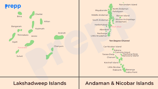
- This zone, which accounts for 0.3% of India's total geographical area, is one of the three tropical moist evergreen forest zones.
- The islands are home to unique flora and fauna. These islands are high endemism hotspots, with some of India's finest evergreen forests and a diverse range of corals.
- The islands are divided into two major groups: the Lakshadweep Islands and the Andaman Islands.
- Andaman Islands
- The Andaman and Nicobar Islands are a 348-island group in the Bay of Bengal that runs north-south.
- The Andaman Islands are about 190 kilometres from the nearest point on the mainland, Cape Negrais in Burma.
- The Great Andaman (300 km long) is made up of five islands that are close together, with the Little Andaman to the south.
- The Nicobar groups of islands are separated from the Andamans and from one another by 800 m deep channels.
- Some of the endemic fauna of the Andaman and Nicobar Islands include the Narcondam hornbill and the South Andaman krait.
- Lakshadweep Islands
- The Lakshadweep Islands are a group of 27 small islands located in the Arabian Sea. They are 320 kilometres from Kerala's coast.
- The Lakshadweep is made up of 25 coral islets with a typical reef lagoon system rich in biodiversity. However, the densely populated Lakshadweep islands have almost no natural vegetation.
Coastal Region
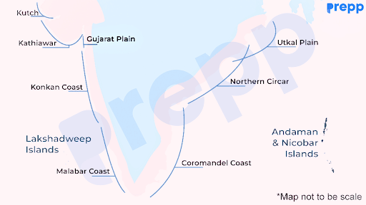
- The coastal region accounts for 2.5 percent of total geographical area, and its sandy beaches, mangroves, mud flats, coral reefs, and marine angiosperm pastures make it India's wealth and health zone.
- The coastline from Gujarat to the Sunderbans is estimated to be 5,423 kilometres long.
Ecological Problems of These Regions
- Loss of Species and Biomass: Human activities are responsible for the majority of threats to species, sites, and habitats.
- Changes in Climatic Conditions: When a forest is cut and burned to make way for cropland and pastures, the carbon stored in the tree trunks combines with oxygen and is released into the atmosphere as CO2. This amplifies the greenhouse effect and contributes to rising global temperatures.
- Drying up of rivers and aquifers: Rivers and aquifers are drying up as a result of increased forest removal. Reduced rainfall reduces the percolation of water in the underground, lowering the levels of the underground water-table.
- Floods and Droughts: As CO2 levels rise in the atmosphere, temperatures rise, resulting in floods and droughts. Water evaporates quickly as a result of the high temperature. Eroded soil that lacks vegetative cover cannot retain moisture for long. As a result, this causes droughts.
- Desertification: The continuous expansion of deserts into previously semi-arid regions is a serious manifestation of the long-term effects of land degradation and intensive soil erosion.
- Rapid melting of glaciers: This is a result of global warming, which is depleting the sources of fresh water for our rivers and streams that flow from the Himalayan ranges.
Conclusion
Biodiversity is essential to all life on Earth. Many resources have been depleted as a result of increased human activity, paving the way for global warming, climatic changes, habitat loss, and ecosystem imbalance. It also has an effect on human health because of dangerous diseases caused by various types of pollution. Biogeography has been used in one of the major recent approaches to classifying India's ecosystems. The main goal of this exercise was to create a biogeographical classification based on existing data that will allow conservation planning at both the national and state levels.
FAQs
Question: What are biogeographic zones, and how many are there in India?
Answer: Biogeographic zones are areas with distinct ecological and geographic characteristics. India is divided into 10 biogeographic zones, each with unique flora, fauna, and climate.
Question: Why is the Western Ghats considered a biodiversity hotspot?
Answer: The Western Ghats is considered a biodiversity hotspot due to its rich variety of species, many of which are endemic to the region. It supports rainforests, evergreen forests, and a diverse range of wildlife, including several endangered species.
Question: What types of ecosystems are found in the Trans-Himalayan zone?
Answer: The Trans-Himalayan zone consists of cold deserts, sparse vegetation, and unique species like the snow leopard, Tibetan antelope, and blue sheep. The harsh climate and high-altitude landscapes define this zone.
Question: What makes the Gangetic Plains ecologically significant?
Answer: The Gangetic Plains are ecologically significant due to their fertile soils and extensive water systems. These plains support grasslands, wetlands, and a variety of species, including crocodiles, dolphins, and migratory birds.
Question: How do the coastal biogeographic zones contribute to India’s biodiversity?
Answer: India’s coastal biogeographic zones are rich in ecosystems such as mangroves, coral reefs, and beaches. These areas support marine life like sea turtles, coral species, and dugongs, playing a crucial role in maintaining marine biodiversity.
MCQs
- Which of the following species is native to the Trans-Himalayan zone?
A. Bengal Tiger
B. Snow Leopard
C. Olive Ridley Turtle
D. Malabar Giant Squirrel
Answer: (B) See the Explanation
The Trans-Himalayan zone is known for its cold desert landscapes and high-altitude regions, which provide a habitat for the snow leopard. This elusive big cat is adapted to survive in the harsh, cold climates of the Trans-Himalayan region, making it a key species in this biogeographic zone. Other species like the Tibetan antelope and blue sheep also inhabit this zone.
- The Thar Desert is part of which biogeographic zone?
A. Semi-Arid
B. Desert
C. Deccan Peninsula
D. Gangetic Plains
Answer: (B) See the Explanation
The Thar Desert, located in Rajasthan and parts of Gujarat, falls under the Desert biogeographic zone. It is characterized by an arid climate, sand dunes, and sparse vegetation. Species such as the great Indian bustard and desert fox are commonly found here, adapted to the extreme heat and dry conditions.
- The Western Ghats is recognized as a biodiversity hotspot because:
A. It covers a large geographical area
B. It has a high level of species endemism
C. It is sparsely populated
D. It has a tropical climate
Answer: (B) See the Explanation
The Western Ghats is a globally recognized biodiversity hotspot due to its high level of species endemism—many species found here are not found anywhere else in the world. The region supports a wide range of ecosystems, from tropical rainforests to evergreen forests, and is home to species like the Malabar giant squirrel, Nilgiri tahr, and lion-tailed macaque.
- Which biogeographic zone includes the Andaman & Nicobar Islands?
A. Islands
B. Coasts
C. Western Ghats
D. Northeast India
Answer: (A) See the Explanation
The Andaman & Nicobar Islands are part of the Islands biogeographic zone. These islands are known for their unique marine ecosystems, coral reefs, and rich biodiversity, including species like the saltwater crocodile, Nicobar pigeon, and various coral species.
- The Gangetic Plains are primarily known for which type of ecosystem?
A. Mangroves
B. Coral reefs
C. Grasslands and wetlands
D. Tropical rainforests
Answer: (C) See the Explanation
The Gangetic Plains are characterized by their grasslands and wetlands, which are supported by the fertile river systems of the Ganga and Yamuna rivers. This region provides habitats for species such as the gangetic dolphin, crocodiles, and various migratory birds, making it an ecologically significant area.
GS Mains Questions and Model Answers
Q1: Discuss the role of biogeographic zones in biodiversity conservation in India.
Answer: Biogeographic zones play a crucial role in biodiversity conservation by providing a framework for understanding the distribution of ecosystems and species. Each zone, such as the Western Ghats, Himalayas, or Northeast India, has unique ecological characteristics that require region-specific conservation strategies. These zones help identify endemic species and facilitate targeted conservation efforts to protect biodiversity. They also aid in addressing environmental challenges such as habitat destruction, deforestation, and climate change. The diversity of India’s biogeographic zones contributes to the country’s overall biodiversity, making them integral to national conservation policies.
Q2: Analyze the significance of the Western Ghats and Northeast India as biodiversity hotspots.
Answer: Both the Western Ghats and Northeast India are globally recognized as biodiversity hotspots due to their exceptional levels of species richness and endemism. The Western Ghats, with its tropical rainforests and evergreen forests, supports species like the lion-tailed macaque and Nilgiri tahr, while Northeast India’s rainforests and alpine meadows are home to species such as the red panda and clouded leopard. These regions face threats from deforestation, habitat loss, and climate change, making conservation efforts crucial. Their biodiversity contributes not only to India’s natural heritage but also to the global ecosystem.
Q3: Evaluate the challenges of conserving biodiversity in India’s desert and semi-arid zones.
Answer: Conserving biodiversity in India’s desert and semi-arid zones, such as the Thar Desert and regions of Gujarat and Rajasthan, poses several challenges due to the harsh climatic conditions, scarcity of water, and desertification. Species such as the great Indian bustard and blackbuck are endangered due to habitat loss and competition with humans for resources. Additionally, overgrazing and land degradation further threaten these fragile ecosystems. Effective conservation requires sustainable management practices, including water conservation, habitat restoration, and wildlife protection, to maintain biodiversity in these zones.
Previous Year Questions on Biogeographic Zones in India
1. UPSC CSE Prelims 2020
Question: Which one of the following National Parks lies completely in the temperate alpine zone?
A. Manas National Park
B. Namdapha National Park
C. Neora Valley National Park
D. Valley of Flowers National Park
Answer: D
Explanation: The Valley of Flowers National Park lies in the temperate alpine zone of the Western Himalayas. It is known for its meadows of endemic alpine flowers and is home to a diverse range of species, including the snow leopard and Himalayan musk deer.
2. UPSC CSE Prelims 2019
Question: Consider the following pairs:
- Great Indian Bustard — Desert National Park
- Snow Leopard — Nanda Devi Biosphere Reserve
- Swamp Deer — Keoladeo National Park
Which of the pairs given above are correctly matched?
A. 1 and 2 only
B. 2 and 3 only
C. 1 and 3 only
D. 1, 2, and 3
Answer: A
Explanation:
- Great Indian Bustard is found in the Desert National Park in Rajasthan, part of the Desert biogeographic zone.
- Snow Leopard is found in the Nanda Devi Biosphere Reserve, located in the Himalayan biogeographic zone.
- Swamp Deer is not found in Keoladeo National Park, which is primarily known for bird species, especially migratory birds.
3. UPSC CSE Mains 2017 (GS Paper 3)
Question: "India’s biodiversity is vast and varied, spread across different biogeographic zones." Discuss the role of these zones in biodiversity conservation and the challenges faced in managing them.
Answer:
- Biogeographic zones provide a framework for understanding the diversity of ecosystems and species.
- Key zones: Western Ghats, Himalayas, Gangetic Plains, and Coasts.
- Conservation challenges: habitat loss, deforestation, climate change, and human-wildlife conflict.
- Importance of region-specific conservation strategies and sustainable management practices to preserve biodiversity.
4. UPSC CSE Mains 2016 (GS Paper 3)
Question: "The Trans-Himalayan zone and the Desert zone are both fragile ecosystems facing unique challenges." Compare and contrast these zones with respect to their biodiversity, conservation status, and the impact of climate change.
Answer:
- Trans-Himalayan zone: Cold desert, sparse vegetation, high-altitude species like snow leopard and blue sheep.
- Desert zone: Arid climate, species adapted to desert conditions like the great Indian bustard and desert fox.
- Conservation challenges: desertification, overgrazing, poaching, and water scarcity.
- Impact of climate change: Altered weather patterns, shifting habitats, and increased vulnerability of species.
Download the PREPP App and attempt FREE IAS Exam Mock Tests and get complete study material!

Full Test - 04: UPSC CSE Prelims CSAT (Paper-II)
Full Test - 03: UPSC CSE Prelims CSAT (Paper-II)
UPSC CSE Prelims 2026 GS Paper 1 Question Paper (24-May-2026)
UPSC CSE Prelims 2026 CSAT Paper 2 Question Paper (24-May-2026)

17 February 2025 | The Hindu Must Read Articles | Current Affairs

16 February 2026 | The Hindu Must Read Articles | Current Affairs

13 February 2026 | The Hindu Must Read Articles | Current Affairs









Comments