Sagar Vani System – Science & Technology Notes
The Sagar Vani system is a revolutionary initiative by the Indian government aimed at enhancing communication and safety in the maritime domain. The “Sagar Vani” app was launched on the foundation day of Ministry of Earth Sciences. It is a comprehensive and integrated system designed to provide real-time information and services to mariners, fishermen, and other stakeholders operating in Indian waters. In this article, we will discuss regarding various aspects of the Sagar Vani system, including its features, applications, challenges, and its overall impact on maritime communication which will be helpful for UPSC exam preparation.
Table of Contents
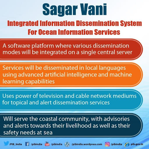
What is the Sagar Vani System?
- The Sagar Vani system is an advanced maritime communication network developed by the Indian National Centre for Ocean Information Services (INCOIS).
- It leverages modern technologies and integrates various platforms to provide timely and reliable information to mariners and other users.
- The system primarily operates through Very High Frequency (VHF) radio, Automatic Identification System (AIS), and satellite-based communication.
- Sagar Vani will use advanced artificial intelligence and machine learning to disseminate information in local languages.
- INCOIS is generating information for 'Sagar Vani' by combining satellite data with historical climatic data collected by sea level gazers and other observing systems.
- ESSO-INCOIS has implemented cutting-edge technologies and tools to provide timely dissemination of Ocean Information and Advisory Services such as Potential Fishing Zone (PFZ) advisories, Ocean State Forecast (OSF), High Wave Alerts, and Tsunami early warnings.
- The system also includes the ability to grant access to various stakeholders (NGOs, State Fishery Departments, Disaster Management Authorities, and so on) so that they, too, can disseminate ocean information and alerts to the user community.
ESSO-INCOIS
|
| Other Relevant Links | |
|---|---|
| Digital India | Quantum computing |
| Project brainwave | Locky Ransomware, Petya, WannaCry |
| Hindi word for computer i.e., “SANGANAK” | India’s first technology and innovation support centre (TISC) |
| Net neutrality | National cyber coordination centre |
| Hortnet | Digital Transaction Methodologies |
| Bitcoins | Cyber Swachhta Kendra |
| Bharat Net Project | Wi-Fi Technology |
| Digital Terrestrial Television Transmission System | Internet of Things |
Features of the Sagar Vani System
- Real-time Weather and Oceanographic Information: The system provides mariners with real-time weather updates, oceanographic data, and tidal information. This enables them to make informed decisions regarding navigation, fishing, and other maritime activities.
- Distress Alert System: The Sagar Vani system includes a distress alert system that enables mariners to send distress signals in case of emergencies. This feature ensures quick response and coordination for search and rescue operations.
- Maritime Safety Information: The system broadcasts vital maritime safety information, such as navigational warnings, meteorological warnings, and notices to mariners. This helps mariners avoid potential hazards and navigate safely.
- Fisheries Advisory Services: The Sagar Vani system also caters to the needs of fishermen by providing them with important information related to potential fishing zones, weather conditions, and fish migration patterns. This enhances their fishing efficiency and safety.
- Mobile App and Web Portal: The Sagar Vani system offers a user-friendly mobile application and web portal, allowing easy access to information and services. Users can access real-time data, view charts, and receive alerts on their smartphones or computers.
Application of the Sagar Vani System
- Maritime Safety: The Sagar Vani system plays a crucial role in enhancing safety at sea by providing real-time information on navigational hazards, weather conditions, and emergency response protocols.
- Efficient Maritime Operations: With improved communication channels and accurate weather forecasts, Sagar Vani enables optimized maritime operations, including vessel traffic management, efficient port operations, and timely cargo handling.
- Search and Rescue Operations: The system facilitates effective search and rescue operations by enabling distress alerts and providing accurate positioning information. It helps in the timely deployment of resources and coordination between various agencies involved in rescue missions.
- Fisheries Management: The Sagar Vani system aids in sustainable fisheries management by providing information on potential fishing zones, fish migration patterns, and weather conditions. This assists fishermen in optimizing their catch and avoiding areas with restricted fishing activities.
- Coastal Security: The system contributes to coastal security by monitoring vessel movements and detecting any suspicious activities. It assists security agencies in safeguarding national waters and preventing illegal activities, such as smuggling and piracy.
- Disaster Management: Sagar Vani aids in disaster management efforts by disseminating early warnings, coordinating rescue operations, and facilitating communication between various agencies involved in disaster response.
Challenges Related to Sagar Vani System
- Technological Infrastructure and Connectivity: Setting up and maintaining the required technological infrastructure, including coastal towers and communication equipment, across the vast coastline poses a significant challenge.
- Connectivity in Rural Areas: Establishing connectivity in remote and inaccessible coastal regions remains a challenge, and efforts must be made to ensure seamless coverage throughout the coastline.
- User Awareness and Training: To fully utilize the system's potential, users need to be aware of its features and trained in its operation. Conducting regular training programs and creating awareness among mariners and fishermen becomes crucial.
- Integration with International Systems: Since maritime communication involves international waters, integrating the Sagar Vani system with global communication networks and harmonizing protocols poses challenges that need to be addressed for seamless coordination.
- Cybersecurity: As the Sagar Vani system relies heavily on technology and data transmission, safeguarding against cyber threats and ensuring the security of communication channels is of utmost importance.
Conclusion
The Sagar Vani system has emerged as a game-changer in maritime communication and safety. Its comprehensive features and real-time information provision significantly enhance the efficiency, safety, and productivity of mariners, fishermen, and other stakeholders. Addressing the challenges and continuously upgrading the system will ensure its effectiveness in the long run, making Indian waters safer and more navigable.
| Other Relevant Links | |
|---|---|
| Science & Technology Policy in India | Scientific Policy Resolution 1958 |
| Science & Technology Policy of 1983 | Science & Technology Policy of 2003 |
| Science, Technology and Innovation Policy 2013 | New Initiatives Aligned with the National Agenda |
| India and World collaboration in science projects | Technology Vision Document 2035 |
FAQs
Question: What is the Sagar Vani System?
Answer: The Sagar Vani System is an initiative by the Ministry of Earth Sciences, India, aimed at providing real-time ocean information services to users, including fishermen, researchers, and policy makers.
Question: Who developed the Sagar Vani System?
Answer: The Sagar Vani System was developed by the Ministry of Earth Sciences (MoES), with support from the Indian National Centre for Ocean Information Services (INCOIS) and other relevant agencies.
Question: What is the primary purpose of the Sagar Vani System?
Answer: The primary purpose of the Sagar Vani System is to provide timely and accurate ocean data such as weather forecasts, tsunami warnings, and potential fishing zones to aid maritime safety and livelihood.
Question: How does the Sagar Vani System help fishermen?
Answer: The Sagar Vani System helps fishermen by delivering location-based ocean information, including weather forecasts, potential fishing zones, and advisories on fishing safety, improving their livelihood and safety.
Question: What technologies are used in the Sagar Vani System?
Answer: The Sagar Vani System uses a combination of satellite communication, mobile apps, and GIS (Geographical Information Systems) technology to provide real-time ocean information to users.
MCQs
1. What is the primary focus of the Sagar Vani System?
A) Air pollution monitoring
B) Ocean data and safety
C) Space exploration
D) Renewable energy
Answer: (B) See the Explanation
Explanation: The primary focus of the Sagar Vani System is to provide accurate and timely ocean data and safety information, including weather forecasts, tsunami warnings, and fishing zone advisories.
2. Which ministry is responsible for the development of the Sagar Vani System?
A) Ministry of Environment, Forest and Climate Change
B) Ministry of Earth Sciences
C) Ministry of Science and Technology
D) Ministry of Defence
Answer: (B) See the Explanation
Explanation: The Sagar Vani System was developed by the Ministry of Earth Sciences (MoES) to provide ocean data services such as weather forecasts and tsunami warnings to users.
3. Which technology is used by the Sagar Vani System to provide real-time information?
A) Blockchain
B) Satellite communication and mobile apps
C) Artificial intelligence
D) Drone technology
Answer: (B) See the Explanation
Explanation: The Sagar Vani System utilizes satellite communication, mobile applications, and GIS technology to deliver real-time ocean data such as forecasts, warnings, and advisories to the public.
4. Who are the key beneficiaries of the Sagar Vani System?
A) Fishermen
B) Researchers
C) Maritime safety personnel
D) All of the above
Answer: (D) See the Explanation
Explanation: The Sagar Vani System benefits a wide range of users including fishermen, researchers, and maritime safety personnel, providing them with vital information related to ocean conditions and safety.
5. How does the Sagar Vani System contribute to fishermen’s safety?
A) Provides fishing gear
B) Offers weather forecasts and fishing zone information
C) Issues tsunami warnings only
D) Tracks fishing boats
Answer: (B) See the Explanation
Explanation: The Sagar Vani System offers fishermen weather forecasts, potential fishing zones, and safety advisories, thus improving both their safety at sea and the efficiency of their fishing operations.
GS Mains Questions and Model Answers
Q1: Discuss the role of the Sagar Vani System in enhancing maritime safety and coastal livelihood in India.
Answer: The Sagar Vani System plays a crucial role in enhancing maritime safety and coastal livelihood by providing real-time ocean data, weather forecasts, tsunami warnings, and potential fishing zones. For fishermen, this system offers vital information that helps in planning their fishing activities safely and efficiently. Furthermore, it aids coastal communities in disaster preparedness by providing early warning of natural calamities like tsunamis. The integration of mobile technology and satellite communication makes it accessible to a wide audience, thereby improving overall maritime safety and supporting sustainable livelihoods along India’s coastlines.
Q2: Explain the technological components involved in the Sagar Vani System and their significance in delivering ocean information.
Answer: The Sagar Vani System relies on satellite communication, mobile applications, and GIS (Geographical Information Systems) to provide real-time ocean data. Satellites are used to monitor weather patterns, sea conditions, and to track storms and tsunamis, while mobile apps and GIS allow the dissemination of this information to the users. These technologies ensure that fishermen, researchers, and maritime safety personnel receive timely and location-specific data, helping them make informed decisions. The use of these technologies makes the system highly efficient in delivering critical information for safety and livelihood purposes.
Q3: What are the potential impacts of the Sagar Vani System on the environment and the economy?
Answer: The Sagar Vani System has the potential to significantly improve both environmental and economic outcomes. Environmentally, it contributes to better disaster preparedness by providing early warnings of tsunamis and severe weather conditions. It also encourages sustainable fishing practices by providing real-time data on potential fishing zones. Economically, it enhances the livelihood of fishermen by improving their access to accurate and timely fishing information, reducing the risks associated with fishing, and increasing efficiency. The system’s ability to support safe and sustainable maritime activities is crucial for the long-term health of India’s coastal ecosystems and economy.
Previous Year Questions on Oceanography and Maritime Safety
1. UPSC CSE Mains 2021 (GS Paper 3):
Question: "Discuss the importance of early warning systems in mitigating the effects of natural disasters, with a focus on ocean-related disasters such as tsunamis."
Answer: Early warning systems play a vital role in mitigating the effects of natural disasters by providing timely alerts that allow individuals and communities to prepare and evacuate if necessary. In the context of ocean-related disasters like tsunamis, early warning systems such as the ones implemented under the Sagar Vani System can save lives by alerting coastal communities well in advance. These systems utilize advanced satellite and communication technologies to track seismic activities and ocean conditions, ensuring that affected regions receive immediate warnings to reduce casualties and damages.
2. UPSC CSE Mains 2019 (GS Paper 2):
Question: "Explain the role of government initiatives like the Sagar Vani System in enhancing the livelihood of coastal communities."
Answer: Government initiatives such as the Sagar Vani System play a significant role in enhancing the livelihoods of coastal communities by providing them with essential information about weather conditions, tsunami warnings, and potential fishing zones. By offering timely and accurate oceanic data, these systems help local fishermen plan their activities better, ensuring safety at sea and more efficient fishing practices. Moreover, the system helps reduce the loss of life and property in the event of natural calamities, supporting the overall economic stability of coastal regions.
Download the PREPP App and attempt FREE IAS Exam Mock Tests and get complete study material!

Full Test - 04: UPSC CSE Prelims CSAT (Paper-II)
Full Test - 03: UPSC CSE Prelims CSAT (Paper-II)
UPSC CSE Prelims 2026 GS Paper 1 Question Paper (24-May-2026)
UPSC CSE Prelims 2026 CSAT Paper 2 Question Paper (24-May-2026)

17 February 2025 | The Hindu Must Read Articles | Current Affairs

16 February 2026 | The Hindu Must Read Articles | Current Affairs

13 February 2026 | The Hindu Must Read Articles | Current Affairs









Comments