River Interlinking Projects in India - Geography Notes
The river Inter-linking Project is a large-scale project that aims to effectively manage India's water resources. Connecting Indian rivers through a network of reservoirs and canals to improve irrigation and groundwater recharge, and reduce persistent floods in some areas, and water scarcity in others. The idea behind river interlinking is that many parts of the country experience drought while others experience flooding every year. This article will explain to you River Interlinking Projects in India which will be helpful in Geography preparation for the UPSC Civil service exam.
| To Read update on this topic: |
River Interlinking Projects
- The National River Linking Project (NRLP) is a massive engineering feat designed to better manage water resources.
- River Linking is a project that connects two or more rivers by building a network of manually constructed reservoirs and canals, providing river water access to land areas that would otherwise be inaccessible, and reducing the flow of water to the sea.
- It is based on the assumption that surplus water in some rivers can be diverted to deficit rivers by building a network of canals to connect the rivers.
- The Inter-link project has three components:
- Himalayan rivers inter-link components,
- Peninsular component,
- Intrastate rivers linking component.
- The National Water Development Agency under the Ministry of Jal Shakti in India is in charge of the project.
- The National River Linking Project (NRLP), formally known as the National Perspective Plan, envisions inter-basin water transfer projects that will transfer water from water surplus basins where flooding occurs to water-deficit basins where drought and scarcity exist.
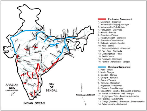
River Interlinking in India
|
|
|
|---|---|
| Important Passes in India | Water Resources in India |
| Major Lakes in India | River Basins in India |
River Interlinking in India - Historical background
- Sir Arthur Cotton, Chief Engineer of the Madras Presidency, proposed the idea of connecting rivers in 1919.
- This idea was revived in 1960 by KL Rao, then Minister of State for Energy and Irrigation, who proposed connecting the rivers Ganga and Cauvery.
- Former Prime Minister Indira Gandhi established the National Water Development Agency in 1982.
- In 2002, the Supreme Court directed the government to complete a plan for connecting rivers by 2003 and implement it by 2016.
- In 2003, the government established a task force to address the issue.
- In 2012, the Supreme Court requested that the project be restarted.
- The Cabinet approved the Ken-Betwa River Linking Project in 2014. However, the project has yet to take off due to government opposition, primarily from environmentalists.
- Around four decades after its conception, India's first river interlinking project, connecting the Ken River in Madhya Pradesh with the Betwa in Uttar Pradesh, finally got off the ground in 2021.
River Interlinking Projects - Himalayan Component
- The Himalayan component of the NRLP has 14 projects in the works.
- Storage dams will be built on the rivers Ganga and Brahmaputra, as well as their tributaries.
- A link between the Ganga and the Yamuna is also proposed.
- Aside from reducing flooding in the Ganga-Brahmaputra river system, it will also benefit drought-prone areas in Rajasthan, Haryana, and Gujarat.
- This component has two sub-components:
- Connecting the Ganga and Brahmaputra basins to the Mahanadi basin.
- Connecting the Ganga's eastern tributaries with the Sabarmati and Chambal river systems.
River Interlinking Projects - Peninsular component
- The peninsular component envisions connecting the 16 rivers of southern India.
- Water from the Mahanadi and Godavari rivers will be diverted to the Krishna, Cauvery, Pennar, and Vaigai rivers.
- There are four sub-component linkages under this component:
- The Mahanadi and Godavari river basins are linked to the Cauvery, Krishna, and Vaigai river systems.
- Ken to Betwa, and Parbati and Kalisindh rivers to Chambal.
- Rivers flowing west from Tapi to the north of Bombay.
- Connecting some rivers that flow west to rivers that flow east.
Intrastate rivers linking component
- In June 2005, India approved and commissioned the National Water Development Agency to identify and complete feasibility studies for intra-state projects that would connect rivers within that state.
- The governments of Nagaland, Meghalaya, Kerala, Punjab, Delhi, Sikkim, Haryana, and the Union Territories of Puducherry, Andaman & Nicobar Islands, Daman & Diu, and Lakshadweep responded that they have no plans to connect intrastate rivers.
- Govt. Puducherry proposed a link between Pennaiyar and Sankarabarani (even though it is not an intrastate project).
- Bihar's state government proposed six inter-linking projects, Maharashtra proposed twenty, Gujarat proposed one, Orissa proposed three, Rajasthan proposed two, Jharkhand proposed three, and Tamil Nadu proposed one inter-linking project between rivers within their respective territories.
River Interlinking Projects - Need
- Reducing Regional Imbalance: India is dependent on erratic and regionally imbalanced monsoon rains. River interconnection will reduce the amount of excess rain and river water that flows into the sea.
- Irrigation for Agriculture: Interlinking can provide a solution to India's rain-fed irrigation problems by transferring surplus water to deficit regions.
- Reducing Water Stress: To some extent, this can help to mitigate the effects of drought and flooding.
- Other advantages include hydropower generation, year-round navigation, job creation, and environmental benefits as dried-up forests and lands are replenished.
River Interlinking Projects - Significance
- The interlinking river is a method of transferring excess water from high-rainfall areas to drought-prone areas. It can thus control both floods and droughts.
- This will also aid in the resolution of the country's water crisis in many areas.
- The project will also aid in the generation of hydropower. This project calls for the construction of numerous dams and reservoirs. If the entire project is completed, it will generate approximately 34000 MW of electricity.
- The project will aid in the enhancement of dry weather flow. That is, during a dry season, excess water stored in reservoirs can be released. This will allow for the least amount of water flow in the rivers.
- This will greatly aid in pollution control, navigation, forests, fisheries, wildlife protection, and so on.
- Indian agriculture is primarily dependent on the monsoon. When the monsoons behave unexpectedly, this causes problems in agricultural output. When irrigation facilities improve, this problem will be solved. The project will provide irrigation services in water-stressed areas.
- The project will also benefit the economy by improving the inland waterways transportation system. Furthermore, rural areas will have an alternate source of income in the form of fish farming, among other things.
- The project will also strengthen the country's defense and security by providing additional waterline defense.
Important River Interlinking Projects in India
| Interlinking Project | Features |
|---|---|
| Manas-Sankosh-Tista-Ganga (MSTG) Link |
|
| Sutlej Yamuna link canal |
|
| Ganga- Cauvery Link Canal |
|
| Beas- Satluj Link Canal |
|
| Ken-Betwa Link Project |
|
| Par-Tapi-Narmada Link Project |
|
| Mahanadi - Godavari link |
|
| Krishna (Srisailam) – Pennar link |
|
| Kurnool- Cuddapah Canal |
|
| Pamba – Achankovil – Vaippar Link Project |
|
River Interlinking Projects - Challenges
- All of this necessitates a high level of engineering ability. As a result, the cost and manpower requirements are enormous.
- The massive project will have an impact on entire ecosystems. The wildlife, flora, and fauna of river systems will suffer as a result of such displacements and changes.
- Many national parks and sanctuaries are located along river systems. All of these factors must be considered while carrying out the project.
- The project has the potential to reduce the flow of freshwater into the sea, affecting marine aquatic life.
- Impact on society: The construction of dams and reservoirs will result in the displacement of a large number of people. Many people will suffer as a result of this. They must be rehabilitated and fairly compensated.
- Controlling floods: Some people are skeptical about this project's ability to control floods. Although it is theoretically possible, India's experience has been quite different.
- There have been instances where large dams such as Hirakud Dam, Damodar Dam, and others have caused flooding in Odisha, West Bengal, and elsewhere.
- Many states, including Kerala, Sikkim, and Andhra Pradesh, have expressed opposition to the river interlinking project.
- International disputes: The effect of building dams and connecting rivers in the Himalayan component of the project will have an impact on neighboring countries.
- This will have to be considered when putting the project together. Bangladesh has been vocal in its opposition to the transfer of water from the Brahmaputra to the Ganga.
Way forward
- There is a need for impact assessments and studies related to this project. The magnitude of the environmental impact is not yet fully understood.
- Local solutions (such as improved irrigation practices) and watershed management should be prioritized.
- The government should instead consider the National Waterways Project (NWP), which "eliminates" conflict between states over river water sharing by using only excess flood water that would otherwise go into the sea.
- More emphasis should be placed on water conservation and equitable distribution. Groundwater enhancement should be given more attention.
National Interlinking of Rivers Authority (NIRA)
- NIRA is intended to be an autonomous independent body for the planning, investigation, financing, and implementation of river interlinking projects in the country.
- NIRA will serve as a coordinating body for all river-linking projects and will be led by a Government of India Secretary-rank officer.
- It will take the place of the current National Water Development Agency (NWDA).
- It will coordinate with neighboring countries, concerned states, and departments, and will have authority over environmental, wildlife, and forest clearances under river linking projects, as well as their legal aspects.
- NIRA will have the authority to raise funds and act as a repository for borrowed funds, money received on deposit, or interest-bearing loans.
- It will also be able to establish Special Purpose Vehicles (SPVs) for individual link projects.
Conclusion
The Rivers Inter-linking Project is a large-scale project that aims to manage India's water resources effectively. Connecting Indian rivers via a network of reservoirs and canals to improve irrigation and groundwater recharge, as well as to reduce persistent floods in some areas and water scarcity in others. The project will also benefit the economy by improving the transportation system for inland waterways. Furthermore, rural areas will have an alternate source of income in the form of, among other things, fish farming.
|
|
|
|---|---|
| Geography Notes | Physical Geography |
| India's Physiographic Divisions | Indian Drainage Systems |
| River Systems in Peninsular India | River Systems of Himalayan Drainage |
| Smaller Rivers of India flowing towards West | Smaller Rivers of India flowing towards East |
| Climatology | Geomorphology |
FAQs
Question: What is the objective of river interlinking in India?
Answer: The objective of river interlinking in India is to transfer water from surplus river basins to water-scarce regions for irrigation, flood control, and hydropower generation, thereby addressing water scarcity and enhancing agricultural productivity.
Question: What is the National Perspective Plan (NPP)?
Answer: The National Perspective Plan (NPP) is a government initiative formulated in 1980 that outlines the river interlinking projects in India. It includes linking Himalayan and Peninsular rivers to manage water resources more effectively.
Question: How does river interlinking help in flood management?
Answer: River interlinking helps in flood management by diverting excess water during the monsoon season from flood-prone areas, such as Bihar and Assam, to drought-prone regions, thereby reducing flood risks.
Question: What are the environmental concerns associated with river interlinking?
Answer: The environmental concerns associated with river interlinking include potential harm to aquatic ecosystems, loss of biodiversity, deforestation, and changes in the natural flow of rivers, which could affect ecosystems and wildlife habitats.
Question: Which major rivers are included in the Peninsular Rivers Development?
Answer: The Peninsular Rivers Development includes rivers like the Mahanadi, Godavari, Krishna, and Cauvery, which are linked to divert surplus water to water-deficient regions in southern India.
MCQs
1. Which of the following rivers is part of the Himalayan Rivers Development under the river interlinking projects?
A. Godavari
B. Cauvery
C. Ganga
D. Krishna
Answer: (C) See the Explanation
The Himalayan Rivers Development focuses on rivers like the Ganga and Brahmaputra, while the Godavari and Cauvery are part of the Peninsular Rivers Development.
2. Which government body formulated the National Perspective Plan for river interlinking?
A. Ministry of Environment
B. Ministry of Water Resources
C. National Green Tribunal
D. Central Pollution Control Board
Answer: (B) See the Explanation
The Ministry of Water Resources formulated the National Perspective Plan (NPP) for river interlinking in 1980 to address water scarcity and flood management.
3. What is the primary aim of the Peninsular Rivers Development project?
A. Generate nuclear energy
B. Divert surplus water to water-scarce regions
C. Increase fishery production
D. Control urban pollution
Answer: (B) See the Explanation
The primary aim of the Peninsular Rivers Development is to divert surplus water from rivers like the Mahanadi and Godavari to water-scarce regions in southern India, particularly to mitigate drought.
4. What are the potential negative impacts of river interlinking?
A. Increased employment opportunities
B. Higher rainfall
C. Environmental degradation and displacement
D. Growth in urban infrastructure
Answer: (C) See the Explanation
The potential negative impacts of river interlinking include environmental degradation, loss of ecosystems, and displacement of local communities due to the construction of reservoirs and canals.
5. Which Indian state is most likely to benefit from the Godavari-Cauvery link under the river interlinking project?
A. Punjab
B. Maharashtra
C. Tamil Nadu
D. Assam
Answer: (C) See the Explanation
Tamil Nadu is one of the key beneficiaries of the Godavari-Cauvery link under the Peninsular Rivers Development project, which aims to address water scarcity in the state.
GS Mains Questions and Model Answers
1. Discuss the significance of river interlinking projects in addressing water scarcity and improving agricultural productivity in India.
Answer: River interlinking projects in India are significant for addressing water scarcity, particularly in drought-prone regions. By transferring water from surplus rivers like the Ganga and Brahmaputra to water-scarce areas in southern and western India, the projects aim to provide much-needed irrigation. This can enhance agricultural productivity and ensure water security for both drinking and industrial use. Additionally, the projects aim to mitigate flood risks by diverting excess water from flood-prone areas, especially during the monsoon season. Despite the potential benefits, these projects also raise concerns about environmental degradation and the displacement of local communities. Overall, river interlinking offers a comprehensive solution to India’s water management challenges, provided it is implemented with proper environmental safeguards.
2. Analyze the environmental and social challenges posed by the river interlinking projects in India.
Answer: The river interlinking projects in India, while promising to address water scarcity and improve flood management, also pose significant environmental and social challenges. One of the primary environmental concerns is the alteration of ecosystems and the potential loss of biodiversity. The large-scale diversion of rivers could disrupt aquatic life and lead to deforestation. Socially, the construction of reservoirs, canals, and other infrastructure could result in the displacement of local communities, particularly tribal populations. These displaced communities may face challenges in resettlement and loss of livelihood. Therefore, while the river interlinking projects offer solutions to water management issues, careful planning is needed to mitigate their environmental and social impacts.
3. Explain the role of the National Perspective Plan (NPP) in shaping India’s river interlinking initiatives.
Answer: The National Perspective Plan (NPP), formulated by the Ministry of Water Resources in 1980, plays a crucial role in shaping India’s river interlinking initiatives. The NPP outlines the vision for linking surplus and deficit river basins to ensure equitable distribution of water across the country. It divides the project into two main components: the Himalayan Rivers Development and the Peninsular Rivers Development, focusing on both flood management and addressing water scarcity. The NPP is the guiding framework for several river interlinking projects, such as the Ken-Betwa Link and the Godavari-Cauvery Link, aimed at providing irrigation, generating hydropower, and improving water availability in drought-prone areas. The NPP highlights the importance of sustainable water management for the country’s long-term economic and social development.
Previous Year Questions on River Interlinking
1. UPSC CSE Prelims 2019
Question: Which of the following rivers is involved in the Ken-Betwa Link Project, a part of India's river interlinking initiatives?
A. Yamuna
B. Betwa
C. Cauvery
D. Brahmaputra
Answer: B
Explanation: The Ken-Betwa Link Project involves the linking of the Ken and Betwa rivers, which are tributaries of the Yamuna, and is part of India's broader river interlinking initiative.
2. UPSC CSE Mains 2018 (GS Paper 1)
Question: "River interlinking has been proposed as a solution to water scarcity in India, but it poses significant environmental and social challenges." Discuss.
Answer: River interlinking has been proposed as a major solution to address water scarcity in India, especially in drought-prone regions. By transferring water from surplus basins to water -deficient areas, the project promises benefits like improved irrigation, drinking water supply, and hydropower generation. However, the environmental and social challenges associated with these projects are significant. The large-scale diversion of rivers can alter ecosystems, leading to biodiversity loss and environmental degradation. Additionally, the construction of canals and reservoirs can displace thousands of people, particularly tribal communities, and affect their livelihoods. Therefore, while river interlinking offers potential benefits, it requires careful planning and mitigation measures to address its environmental and social impacts.
Download the PREPP App and attempt FREE IAS Exam Mock Tests and get complete study material!

Full Test - 04: UPSC CSE Prelims CSAT (Paper-II)
Full Test - 03: UPSC CSE Prelims CSAT (Paper-II)
UPSC CSE Prelims 2026 GS Paper 1 Question Paper (24-May-2026)
UPSC CSE Prelims 2026 CSAT Paper 2 Question Paper (24-May-2026)

17 February 2025 | The Hindu Must Read Articles | Current Affairs

16 February 2026 | The Hindu Must Read Articles | Current Affairs

13 February 2026 | The Hindu Must Read Articles | Current Affairs









Comments