Outer Himalayas (or Shiwalik) - Geography Notes
Outer Himalayas, also known as the Shiwalik Range, is situated between the Great Plains and the Lesser Himalayas. The elevation ranges from 600 to 1500 metres. It stretches 2,400 kilometres from the Potwar Plateau to the Brahmaputra Valley. The southern slopes are steeper than the northern slopes. The Shiwaliks range in width from 50 km in Himachal Pradesh to less than 15 km in Arunachal Pradesh. This article will explain to you about the Outer Himalayas (or Shiwalik) which will be helpful in Geography preparation for the UPSC Civil service exam.
|
Table of Contents |
Outer Himalayas (or Shiwalik)
- The Shivalik ranges are the Himalayas' southernmost hills. It is separated from the Lesser Himalayas by valleys with flat bottoms. The ancient name for this range was "Upgiri."
- The Outer Himalayas form a continuous chain of over 2400 km. from the northwest Indus gorge to the Brahmaputra in Assam
- The height rarely exceeds 1300 m, and the width of the Shivaliks ranges from 10 to 50 kilometres.
- The southern slopes of the Shivalik ranges in Himachal Pradesh and Punjab are devoid of forest cover. Chaos, the seasonal stream, has severely eroded these slopes.
- Between the Himachal and Shivalik ranges, many longitudinal valleys run parallel to the mountains known as 'Duns,' such as Patli Dun, Kotli Dun, and Dehradun.
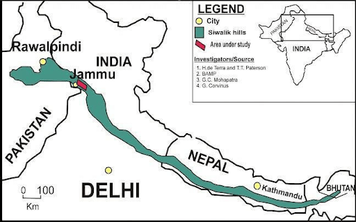
Outer Himalayas (or Shiwalik)

Outer Himalayas (or Shiwalik) - Importance
- The Shiwalik range from North-East India to Nepal is densely forested, but the forest cover decreases west of Nepal (The quantum of rainfall decreases from east to west in Shiwaliks and Ganga Plains).
- The Shivalik range's southern slopes in Punjab and Himachal Pradesh are almost devoid of forest cover. Seasonal streams known as Chos cut deeply into these slopes.
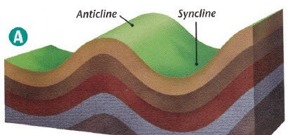
- Valleys are part of synclines, while hills are part of anticlines or anti-synclines.
- The Siwalik Mountains are sometimes thought to include the southern hills of the Assam Himalayas, which extend eastward for 400 miles across southern Bhutan to the Brahmaputra River. The Shiwaliks are the Himalayas' most isolated range.
- These categories' three main characteristics are
- They have a diameter of 10-50 km and a height of 900-1100 metres.
- These sections are made up of uncoordinated rivers that flow south from the main Himalayas.
- Dense alluvium rocks cover these valleys.
- The Duns are the names given to the long valley that runs between the small Himalayas and the Shiwaliks, including DehraDun, Kotli Dun, and Patli Dun.
- Different areas have different names for the Shiwaliks.
| Region/area | Names of Shiwalik |
|---|---|
| Jammu Region | Jammu Hills |
| Dafla, Miri, Abor and Mishmi Hills | Arunachal Pradesh |
| The Dhang Range, Dundwa Range | Uttarakhand |
| Churia Ghat Hills | Nepal |
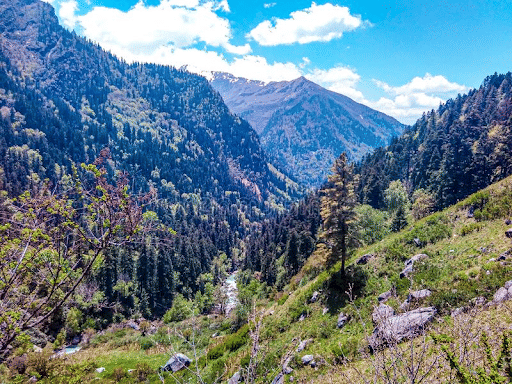
Formation of Duns (Duras)
- Shivalik Hills were formed by conglomerate accumulation (sand, stone, silt, gravel, debris, etc.).
- During the initial stages of deposition, these conglomerates obstructed the courses of rivers draining from the higher reaches of the Himalayas, forming temporary lakes.
- These temporary lakes accumulated more and more conglomerates as time passed. The conglomerates had settled well at the lakes' bottoms.
- When rivers were able to cut their paths through lakes filled with conglomerate deposits, the lakes were drained away, leaving behind plains known as 'duns' or 'duns' in the west and 'duars' in the east.
- The best example is Dehradun, Uttarakhand.
- Other notable dunes include Kotah, Patli Kothri, Chumbi, Kyarda, Chaukhamba, Udhampur, and Kotli.
Conclusion
The Shiwalik Range, commonly known as the Outer Himalayas, is located between the Great Plains and the Lesser Himalayas. The Shiwalik range stretches from North-East India to Nepal, but forest cover reduces west of Nepal. Dehradun, Kotli Dun, and Patli Dun are names given to the long valley that stretches between the Little Himalayas and the Shiwaliks. The Shiwaliks are known by many names in different locations.
FAQs
Question: What are the Shiwalik Hills?
Answer: The Shiwalik Hills, also known as the Outer Himalayas, are the southernmost range of the Himalayan mountain system, extending across northern India, Nepal, Bhutan, and Pakistan.
Question: What is the average elevation of the Shiwalik Range?
Answer: The Shiwalik Range has an average elevation between 600 to 1,500 meters, making it lower than the Middle and Greater Himalayan ranges.
Question: How were the Shiwalik Hills formed?
Answer: The Shiwalik Hills were formed during the Tertiary Period due to the sedimentation of material eroded from the higher Himalayas, making them geologically young and fragile.
Question: What are duns, and where are they located in the Shiwalik region?
Answer: Duns are longitudinal valleys found between the Shiwalik and Middle Himalayas. Notable examples include the Dehradun, Kangra, and Patli Dun valleys.
Question: Why is the Shiwalik Range prone to landslides?
Answer: The Shiwalik Range is prone to landslides because it is composed of unconsolidated sediments, which are loosely bound and easily eroded, making the region geologically unstable.
MCQs
1. Which of the following best describes the Shiwalik Range?
A) The highest range of the Himalayas
B) The southernmost range of the Himalayas
C) A volcanic range in southern India
D) A plateau region in central India
Answer: (B) See the Explanation
Explanation: The Shiwalik Range, also known as the Outer Himalayas, is the southernmost range of the Himalayan mountain system, stretching from the Indus River to the Brahmaputra River.
2. What is the geological composition of the Shiwalik Hills?
A) Basalt and granite
B) Sandstone, conglomerates, and siltstones
C) Limestone and chalk
D) Marble and schist
Answer: (B) See the Explanation
Explanation: The Shiwalik Hills are primarily composed of sandstone, conglomerates, and siltstones, which are the result of sedimentation from the higher Himalayan ranges.
3. Which valley is located between the Shiwalik and the Middle Himalayas?
A) Kangra Valley
B) Narmada Valley
C) Ganga Valley
D) Godavari Valley
Answer: (A) See the Explanation
Explanation: The Kangra Valley is a prominent dun or valley located between the Shiwalik and Middle Himalayan ranges.
4. In which geological period were the Shiwalik Hills formed?
A) Cretaceous
B) Tertiary
C) Jurassic
D) Precambrian
Answer: (B) See the Explanation
Explanation: The Shiwalik Hills were formed during the Tertiary Period as part of the overall Himalayan orogeny.
5. What type of ecosystem is found south of the Shiwalik Hills?
A) Arid desert
B) Mangrove forests
C) Terai region
D) Alpine tundra
Answer: (C) See the Explanation
Explanation: The Terai region, characterized by marshy land and dense forests, is found to the south of the Shiwalik Hills, acting as a transition zone between the hills and the Indo-Gangetic plains.
GS Mains Questions and Model Answers
Q1: Discuss the geological significance of the Shiwalik Range in the context of Himalayan formation.
Answer: The Shiwalik Range plays a significant role in the overall structure of the Himalayan mountain system. Formed during the Tertiary Period, the Shiwaliks are composed of unconsolidated sediments such as sandstone, conglomerates, and siltstones. These sediments were deposited by rivers flowing from the higher Himalayas. The Shiwaliks are geologically younger and more fragile than the Middle and Greater Himalayas. Their formation is closely linked to the ongoing tectonic activity in the region, which continues to shape the Himalayan landscape through processes like erosion, sedimentation, and uplift.
Q2: Analyze the environmental challenges faced by the Shiwalik region and suggest measures to address them.
Answer: The Shiwalik region faces several environmental challenges, including deforestation, soil erosion, landslides, and habitat degradation. These issues are exacerbated by human activities such as unplanned development, agriculture, and infrastructure projects. The fragile geology of the region, composed of unconsolidated sediments, makes it particularly prone to landslides. To address these challenges, measures such as afforestation, sustainable land-use practices, and the construction of soil conservation structures can help stabilize the region. In addition, promoting eco-friendly development and implementing disaster management plans can mitigate the impacts of environmental degradation.
Q3: Explain the role of the Shiwalik Range in shaping the hydrology and biodiversity of northern India.
Answer: The Shiwalik Range plays a crucial role in the hydrology and biodiversity of northern India. The range serves as a natural barrier, influencing the flow of rivers and the distribution of rainfall in the region. The valleys between the Shiwalik and Middle Himalayas, known as duns, are rich in water resources and support agriculture and human settlements. The Terai region south of the Shiwaliks is characterized by marshes and dense forests, which serve as important habitats for diverse wildlife species, including elephants, tigers, and rhinoceroses. The Shiwalik ecosystem is vital for maintaining the ecological balance and supporting livelihoods in northern India.
Previous Year Questions on Shiwalik Range
1. UPSC CSE Prelims 2019
Question: Which of the following valleys is located between the Shiwalik and Middle Himalayas?
A) Doon Valley
B) Kashmir Valley
C) Kangra Valley
D) Narmada Valley
Answer: A
Explanation: The Doon Valley is located between the Shiwalik and Middle Himalayan ranges. It is one of the most fertile valleys in northern India, known for its agricultural importance.
2. UPSC CSE Mains 2020 (GS Paper 1)
Question: Discuss the environmental vulnerability of the Shiwalik Range and suggest mitigation measures to address the issues.
Answer: The Shiwalik Range is highly vulnerable to landslides, soil erosion, and deforestation due to its composition of unconsolidated sediments. Unplanned development and deforestation have further exacerbated these issues. Mitigation measures include afforestation programs, the construction of check dams to control soil erosion, and promoting sustainable agricultural practices. Additionally, strengthening disaster preparedness and implementing early warning systems for landslides can help minimize the environmental risks in the Shiwalik region.
Download the PREPP App and attempt FREE IAS Exam Mock Tests and get complete study material!

Full Test - 04: UPSC CSE Prelims CSAT (Paper-II)
Full Test - 03: UPSC CSE Prelims CSAT (Paper-II)
UPSC CSE Prelims 2026 GS Paper 1 Question Paper (24-May-2026)
UPSC CSE Prelims 2026 CSAT Paper 2 Question Paper (24-May-2026)

17 February 2025 | The Hindu Must Read Articles | Current Affairs

16 February 2026 | The Hindu Must Read Articles | Current Affairs

13 February 2026 | The Hindu Must Read Articles | Current Affairs









Comments