IRNSS: Indian Regional Navigation Satellite System – Science & Technology Notes
The Indian Regional Navigation Satellite System (IRNSS) is the country's regional satellite navigation system, which was later given the operational title of NavIC or NAVigation with Indian Constellation. The Indian Space Research Organisation (ISRO) launched and operates it. In this article, we will discuss in detail regarding IRNSS which will be helpful for UPSC exam preparation.
Table of Contents
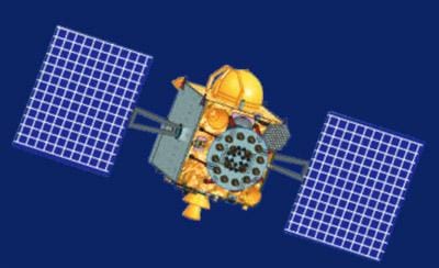
IRNSS Satellite
What is IRNSS?
- IRNSS is an independent regional navigation satellite system being developed by India.
- The Indian Regional Navigation Satellite System (IRNSS) project aims to establish a regional navigational satellite system by combining GEO and GSO spacecraft with cutting-edge ground systems.
- The IRNSS System provides navigation solutions 24 hours a day, seven days a week, with position accuracy better than 20 metres in all weather conditions, anywhere in India and a region extending about 1500 kilometres around India.
- IRNSS will offer two types of services: standard positioning service (SPS), which is available to all users, and restricted service (RS), which is an encrypted service available only to authorised users.
- NavIC aims to improve domestic navigation for Indian users. This navigation system, which is said to cover the entire country of India, now employs seven satellites.
- IRNSS currently consists of eight satellites, three in geostationary orbit and five in geosynchronous orbit.
- Furthermore, the NavIC system includes two frequency bands—L5-band and S-band—which makes it far more accurate than GPS.
- The "Made in India" navigation system also claims to provide better position accuracy (more than 20 metres) in its primary service region.
- IRNSS-1I is expected to replace IRNSS-1A, which was rendered inoperable due to the failure of its three rubidium atomic clocks.
- The International Maritime Organisation (IMO) approved it as a component of the World Wide Radio Navigation System (WWRNS) for use in the Indian Ocean Region beginning in 2020.
| Other Relevant Links | |
|---|---|
| GSLV and Various Engine | Recent National and International Space Missions |
| Cryogenic rockets | Scramjet Engine |
| GSLV Mk III-D1 OR GSAT-19 Mission | ISRO’s World Record PSLV C37 Launch |
| Global Positioning System | Galileo |
| GLONASS | GAGAN |
| Chandrayaan – I & II | Mars Orbiter Mission |
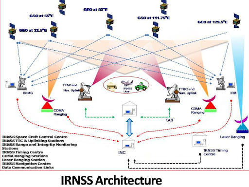
Architecture of IRNSS
The IRNSS is divided into three sections:
- Space: The space segment consists of a constellation of eight satellites, three of which are in geostationary orbit and five of which are in geosynchronous orbit.
- Ground stations for navigation parameter generation and transmission, satellite control, satellite ranging, and monitoring comprise the IRNSS ground segment. A total of 20 stations are planned, the majority of which will be located at airports alongside GAGAN ground elements.
- User: IRNSS will have two Master Control Stations MCS, which may be located alongside GAGAN INMCC.
List of IRNSS Satellites
| Project | Launch Date | Launch Vehicle |
|---|---|---|
| NVS-01 | 29th May 2023 | GSLV-F12 |
| IRNSS-1I | 12th April 2018 | PSLV-C41 |
| IRNSS-1H | 31st August 2017 | PSLV-C39 |
| IRNSS-1G | 28th April 2016 | PSLV-C33 |
| IRNSS-1F | 10th March 2016 | PSLV-C32 |
| IRNSS-1E | 20th January 2016 | PSLV-C31 |
| IRNSS-1D | 28th March 2015 | PSLV-C27 |
| IRNSS-1C | 15th October 2014 | PSLV-C26 |
| IRNSS-1B | 4th April 2014 | PSLV-C24 |
| IRNSS-1A | 1st July 2013 | PSLV-C22 |
Applications of IRNSS / NavIC
- Agriculture & Farming: NavIC assists farmers in optimising crop management, irrigation, and soil nutrient application.
- Terrestrial, Aerial and Marine Navigation: NavIC tracks fishermen in real time and sends alerts in the event of potential hazards at sea.
- Disaster Management: NavIC aids in the tracking and response to natural disasters such as cyclones and floods.
- Vehicle tracking and fleet management: NavIC allows for precise tracking of commercial vehicles, which improves road safety and efficiency.
- Scientific & Technological Advancement: NavIC assists in scientific experiments, geological surveys, and the development of geodetic networks.
- National Security: NavIC enables precise tracking and navigation for military and defence operations.
- Other applications include:
- Integration with mobile phones
- Precise Timing
- Mapping and Geodetic data capture
- Terrestrial navigation aid for hikers and travellers
- Visual and voice navigation for drivers
Benefits of IRNSS / NavIC
- The Indian Regional Navigation Satellite System (IRNSS) provides geospatial positioning data within the Indian subcontinent.
- Users can use it to map their location (altitude, longitude, and latitude).
- India's NavIC system operates independently of GPS and other global systems.
- The goal of developing IRNSS was to reduce India's reliance on foreign navigation satellite systems.
- When fully operational, NavIC open signals are expected to provide accuracy of up to 5 metres, outperforming GPS accuracy of 20 metres.
- NavIC, unlike GPS, uses satellites in high geostationary orbit to ensure consistent coverage over the designated region.
- Unlike GPS, NavIC signals arrive in India at a 90-degree angle, making them easier to receive even in congested or obstructed areas.
- In accordance with the Nirbhaya case verdict, the government made NavIC-based vehicle trackers mandatory for all commercial vehicles in the country in April 2019.
- Qualcomm Technologies has also announced mobile chipsets that support NavIC.
Challenges Related to IRNSS / NavIC
- Failure of atomic clocks: Several existing satellites ceased providing location data after their onboard atomic clocks failed.
- Satellite Replacement: Some of the NAVIC satellites have reached the end of their mission life or have become partially defunct.
- Limited Coverage: While NAVIC covers the entire Indian landmass and a radius of 1,500 km around it, there is a need for additional expansion and ground stations outside of India to improve coverage and accuracy in difficult-to-reach areas.
- User Segment Development: There has been a delay in the development of NAVIC system user receivers, resulting in limited use of navigation services.
- Mobile Compatibility: Mobile phones in India currently lack NAVIC signal processing compatibility, limiting the system's widespread use.
Conclusion
More satellites in a lower orbit than the current constellation would be required to make NavIC truly global, similar to GPS. NavIC's current range extends only 1,500 kilometres beyond Indian territory. However, for our ships and aeroplanes to travel beyond that, we would require satellites in Medium Earth Orbit. We can keep adding MEO satellites to eventually make this global.
| Other Relevant Links | |
|---|---|
| Science & Technology Policy in India | Scientific Policy Resolution 1958 |
| Science & Technology Policy of 1983 | Science & Technology Policy of 2003 |
| Science, Technology and Innovation Policy 2013 | New Initiatives Aligned with the National Agenda |
| India and World collaboration in science projects | Technology Vision Document 2035 |
FAQs
Question: What is IRNSS and what is its primary purpose?
Answer: The Indian Regional Navigation Satellite System (IRNSS), also known as NavIC, is a regional satellite navigation system developed by the Indian Space Research Organisation (ISRO). It is designed to provide accurate positioning and timing information to users within India and surrounding regions, offering better accuracy than GPS in its operational region.
Question: What are the main components of the IRNSS system?
Answer: The IRNSS system consists of three main components: the space segment (satellites in geostationary and geosynchronous orbits), the ground segment (ground stations for satellite control and monitoring), and the user segment (devices such as mobile phones and GPS receivers that use IRNSS signals).
Question: How does IRNSS differ from GPS?
Answer: IRNSS provides regional coverage over India and surrounding areas, whereas GPS offers global coverage. Unlike GPS, IRNSS is designed to improve accuracy within its designated region. Additionally, IRNSS uses geostationary satellites for better signal reception in congested areas, providing more accurate positioning for users in India.
Question: What are the key applications of the IRNSS/NavIC system?
Answer: IRNSS/NavIC has a wide range of applications, including navigation for vehicles, aircraft, and ships, precise timing for telecommunications, disaster management, military operations, and supporting agriculture with better land and crop management.
Question: What challenges does IRNSS face in its implementation?
Answer: Key challenges include limited coverage outside the Indian region, high reliance on geostationary orbits that restrict global coverage, failure of some satellite components (e.g., atomic clocks), and limited integration of IRNSS technology in consumer devices like smartphones.
MCQs
1. What is the full form of IRNSS?
A) Indian Remote Navigation Satellite System
B) Indian Regional Navigation Satellite System
C) Indian Radiant Navigation Satellite System
D) International Regional Navigation Satellite System
Answer: (B) See the Explanation
Explanation: IRNSS stands for the Indian Regional Navigation Satellite System, a regional satellite navigation system developed by ISRO.
2. How many satellites are there in the IRNSS constellation?
A) 5
B) 6
C) 7
D) 8
Answer: (D) See the Explanation
Explanation: The IRNSS system comprises 8 satellites, including 3 in geostationary orbit and 5 in geosynchronous orbit, to ensure effective regional coverage.
3. What is the primary use of IRNSS/NavIC in India?
A) Global positioning
B) Regional satellite navigation
C) Weather forecasting
D) Telecommunication
Answer: (B) See the Explanation
Explanation: IRNSS/NavIC is used primarily for regional satellite navigation, providing accurate positioning information for users within India and surrounding regions.
4. Which of the following bands does IRNSS use for communication?
A) L1-band and L5-band
B) S-band and L5-band
C) L5-band and L1-band
D) S-band and S2-band
Answer: (B) See the Explanation
Explanation: IRNSS uses two main frequency bands: the L5-band and the S-band, which provide improved accuracy for navigation compared to GPS systems.
5. Which of the following is a key application of IRNSS?
A) Marine navigation
B) Vehicle tracking
C) Scientific research
D) All of the above
Answer: (D) See the Explanation
Explanation: IRNSS is used for various applications, including marine navigation, vehicle tracking, and scientific research, among others, making it versatile in many sectors.
GS Mains Questions and Model Answers
Q1: Discuss the significance of IRNSS (NavIC) for India’s national security and economic development.
Answer: IRNSS (NavIC) plays a crucial role in enhancing India’s national security by providing accurate, regional navigation capabilities that are independent of foreign satellite systems. For military applications, NavIC offers precise navigation for defense operations, improving accuracy in missile guidance and troop movements. Additionally, NavIC supports economic development by improving the efficiency of transportation, logistics, and agriculture. It assists in real-time tracking of goods and vehicles, which boosts trade and commerce. Moreover, its integration into mobile technology provides greater connectivity for citizens, contributing to economic inclusivity and progress.
Q2: How does the IRNSS system differ from GPS, and why is it essential for India?
Answer: While GPS provides global coverage, IRNSS is a regional navigation satellite system focused on India and its surrounding areas. IRNSS provides more accurate positioning and reliable service in the region compared to GPS, especially in areas with congested environments. Its use of geostationary satellites gives it a stronger signal in India, which is essential for sectors like agriculture, transportation, and national security. As an independent system, IRNSS reduces India’s dependence on foreign satellite systems, ensuring sovereignty over its navigation infrastructure.
Q3: What challenges does IRNSS face, and how can it be improved for better coverage and accuracy?
Answer: IRNSS faces challenges like limited global coverage, reliance on geostationary satellites, and issues with the replacement of aging satellites. To improve coverage and accuracy, India can deploy more satellites in Medium Earth Orbit (MEO) to extend its reach beyond the current 1500 km radius. Expanding ground stations and enhancing satellite replacement strategies will help maintain system reliability. Additionally, integrating IRNSS with other global navigation systems like GPS and GLONASS could further improve accuracy and provide better backup during technical failures or satellite malfunctions.
Previous Year Questions on IRNSS
1. UPSC CSE Prelims 2020:
Question: What is the primary purpose of IRNSS (NavIC)?
A) To provide global navigation
B) To provide regional navigation services
C) To monitor environmental changes
D) To support global weather forecasting
Answer: (B)
Explanation: The primary purpose of IRNSS (NavIC) is to provide regional navigation services to India and its surrounding regions, enhancing India’s autonomy in navigation systems.
2. UPSC CSE Mains 2019 (GS Paper 3):
Question: Discuss the significance of NavIC in supporting India’s national security and civilian applications.
Answer: NavIC is essential for national security, providing accurate positioning for military operations, including missile guidance and troop movements. For civilian applications, it improves transportation, agriculture, disaster management, and infrastructure development, ensuring better efficiency and safety. It helps in tracking vehicles, optimizing agriculture with precise data, and assisting in maritime navigation, thereby enhancing India’s technological independence and regional security.
Download the PREPP App and attempt FREE IAS Exam Mock Tests and get complete study material!

Full Test - 04: UPSC CSE Prelims CSAT (Paper-II)
Full Test - 03: UPSC CSE Prelims CSAT (Paper-II)
UPSC CSE Prelims 2026 GS Paper 1 Question Paper (24-May-2026)
UPSC CSE Prelims 2026 CSAT Paper 2 Question Paper (24-May-2026)

17 February 2025 | The Hindu Must Read Articles | Current Affairs

16 February 2026 | The Hindu Must Read Articles | Current Affairs

13 February 2026 | The Hindu Must Read Articles | Current Affairs









Comments