HyperSpectral Imaging Satellite (HySIS) – Science & Technology Notes
The Hyperspectral Imaging Satellite (HySIS) is a hyperspectral Earth observation minisatellite developed by the Indian Space Research Organisation (ISRO) to provide imaging services and insights into Indian agriculture, forestry, coastal zone assessments, and other geological environments. HySIS, which was launched in November 2018, used visible (VIS), near infrared (NIR), and shortwave infrared (SWIR) surface imaging to achieve its objectives. In this article, we will discuss in detail regarding Hyperspectral Imaging Satellite which will be helpful for UPSC exam preparation.
Table of Contents
What is HyperSpectral Imagery?
- Imaging satellites have traditionally used cameras that capture the Earth in a few frequency bands.
- Multispectral sources typically cover the visible light optical red, green, and blue bands, as well as a few other frequency ranges.
- However, a revolution is taking place. A growing number of satellites outfitted with hyperspectral cameras will enable us to observe the Earth in extraordinary detail across a wide frequency range — far beyond what the human eye can see and far more detail than existing multispectral sensors.
- Tree and plant species identification, monitoring of air quality (particulate and gaseous) and water quality (e.g., algal bloom detection), tree health observation, and other applications are possible with hyperspectral imagery.
- This unique detector system simultaneously records hundreds of spectral bands with relatively narrow bandwidths (5-10 nm).
- The ability to detect and identify unique trends in land and atmospheric data sets is greatly improved with such detail.
| Other Relevant Links | |
|---|---|
| NASA: Asteroid impact and deflection assessment mission | Commercial use of Lithium-Ion battery technology |
| Water propulsion system in CUBESAT | Neutrino Observatory |
| Indian Space Vision-2025 | Major Policy Initiatives National Optical Fibre network |
| Spectrum Management | Cyber Law |
| Internet, Types of Network and e- Governance | Spectrum Policy in India |
| Mobile Spectrum | Cloud Computing |
| Big Data | Encryption |
| Biometrics | Virtual Reality |
What is ISRO’s Hyperspectral Imaging Satellite?
- ISRO (Indian Space Research Organisation) created HySIS, a full-fledged hyperspectral Earth Observation (EO) satellite set to launch in 2018.
- The HySIS is intended to provide the country with hyperspectral imaging services for a variety of applications such as agriculture, forestry, and assessment of coastal zones, inland waters, soil, and other geological environments, among others.
- The primary satellite of the PSLV-C43 mission, HySIS, weighs approximately 380 kg and is an Earth observation satellite built around ISRO's Mini Satellite-2 (IMS-2) bus.
- The primary goal of HysIS is to study the Earth's surface in the visible, near-infrared, and shortwave infrared spectrums.
- HySIS is a Hyper Spectral Imaging Satellite that will provide users with global coverage on a regular basis while supplementing data from existing multispectral sensors.
- HySIS is equipped with two pushbroom imagers, one of which captures images in the Visible Near Infrared (VNIR) range and the other in the Shortwave Infrared (SWIR) range.
- They are used for Earth observation imagery and are equipped with an optical imaging detector array chip developed by ISRO's Space Application Centre (SAC).
- HysIS houses communications and imaging payloads on the ISRO Mini Satellite-2 bus (IMS-2).
- The mission, which was launched in 2018 on a PSLV-C43 vehicle and was designed to have a five-year lifespan, with an expected end date of 2023.
- On December 2, 2018, the first light image from HySIS was acquired at the NRSC (National Remote Sensing Centre) in Hyderabad, covering parts of Lakhpat in Gujarat, India.
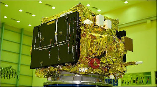
HyperSpectral Imaging Satellite
Other HyperSpectral Satellites in Space
1) EO-1 (NASA)
- NASA launched the EO-1 satellite in 2000, carrying the "Hyperion" hyperspectral sensor.
- In 242 spectral bands, Hyperion produced images with a resolution of 30 metres. Hyperion was a pioneer in hyperspectral imaging from space.
2) PROBA-1 (ESA)
- ESA launched the Project for Onboard Autonomy (PROBA-1) in 2001.
- It was equipped with the CHRIS (Compact High-Resolution Imaging Spectrometer) for medium-resolution hyperspectral imaging.
- At 34m GSD, its hyperspectral mode produced 63 bands. It could, however, be reconfigured to 150 bands with pixel resolution.
3) PRISMA (Italy)
- PRISMA, a medium-resolution hyperspectral satellite, was launched in 2019.
- It is Italy's first of its kind and will help with crop classification, resource management, and environmental monitoring.
- PRISMA (PRecursore IperSpettrale Della Missione Applicativa) generates 250 bands with a GSD of 30m.
4) EnMap (Germany)
- In 2020, Germany launched the Environmental Mapping and Analysis Programme (EnMap).
- This hyperspectral satellite has 228 bands with a GSD of 30m.
5) HISUI (Japan)
- ALOS-3 is equipped with the Hyperspectral and Multispectral Imager (HISUI).
- This Japanese hyperspectral sensor has 185 bands and a resolution of 30m GSD.
6) HyspIRI (Unites States)
- The Hyperspectral Infrared Imager (HyspIRI) is scheduled to launch in 2024.
- It will be outfitted with a VSWIR imaging spectrometer with a GSD of 60m.
Significance of HyperSpectral Imaging Satellite
- The primary goal of HySIS is to study the Earth's surface in the visible, near-infrared, and shortwave infrared spectrums.
- Visible band includes imagery, vegetation, chlorophyll, and sediments.
- Near Infrared includes atmosphere, cloud cover, vegetation land cover transformation.
- Thermal Infrared includes sea surface temperature, forest fires, volcanoes, cloud height, total ozone.
- From 630 km above ground, a hyperspectral imaging satellite can see in 55 spectral or colour bands.
- By reading the spectrum for each pixel of a scene from space, 'Hyspex' imaging allows for the distinct identification of objects, materials, or processes on Earth.
- It can be extremely useful in distinguishing a suspect object or person from the background. This could help detect transborder or other covert movements.
- It can be used for a variety of purposes, including monitoring atmospheric activity and climate change, studies of the Earth's magnetic field, agriculture, forestry, water management, coastal patterns,search for oil and minerals, military surveillance, etc.
Applications of HyperSpectral Imaging Satellite
Agriculture
- Hyperspectral imaging serves as a potent tool for monitoring crop health, identifying nutrient deficiencies, and detecting diseases before visible symptoms emerge.
- This contributes to enhanced agricultural productivity and resource management.
Environmental Monitoring
- The technology enables the identification of pollutants, oil spills, land cover changes, and habitat disruptions.
- Such insights bolster environmental management, conservation, and disaster response strategies.
Geological Surveys
- Hyperspectral imaging aids in identifying minerals, rock formations, and geological structures, supporting geological surveys, resource exploration, and infrastructure planning.
Disease Detection and Management
- The early detection of crop diseases through hyperspectral imaging aids in timely interventions, reducing yield losses and minimizing the use of agrochemicals.
Flood Monitoring and Assessment
- The technology enables real-time monitoring of flood-prone regions, assessment of flood extent, and evaluation of potential impacts on communities and infrastructure. This aids in timely evacuation and relief efforts.
Forest Fire Detection and Management
- Hyperspectral data can pinpoint areas vulnerable to forest fires, facilitating rapid detection, containment, and effective deployment of firefighting resources.
Infrastructure
- Identifying issues in infrastructure assets such as railway tracks, dams, and highways by assessing differences in composition/quality and alerting relevant stakeholders.
Conclusion
Hyperspectral Imaging Satellites epitomize the fusion of cutting-edge technology with practical applications. India's strides in this field have not only contributed to its space capabilities but have also led to advancements in various sectors, from agriculture to disaster management. As we gaze towards the future, the continued evolution of hyperspectral imaging promises to unveil new layers of insight about our planet and further strengthen India's position as a space-faring nation.
| Other Relevant Links | |
|---|---|
| Science & Technology Policy in India | Scientific Policy Resolution 1958 |
| Science & Technology Policy of 1983 | Science & Technology Policy of 2003 |
| Science, Technology and Innovation Policy 2013 | New Initiatives Aligned with the National Agenda |
| India and World collaboration in science projects | Technology Vision Document 2035 |
FAQs
Question: What is Hyperspectral Imaging Satellite (HYSICS)?
Answer: Hyperspectral Imaging Satellite (HYSICS) is a satellite that uses hyperspectral sensors to capture detailed images across various wavelengths. It helps in monitoring land, water, and vegetation for scientific and environmental analysis.
Question: What are the primary applications of HYSICS?
Answer: HYSICS is primarily used in agriculture, forestry, mineralogy, water resource management, and environmental monitoring. It helps in detecting soil moisture, vegetation health, and pollution levels.
Question: How does HYSICS differ from traditional satellite imaging systems?
Answer: Unlike traditional satellites that capture images in a few broad bands, HYSICS captures images in hundreds of narrow bands across the electromagnetic spectrum, providing more detailed information for analysis.
Question: Who developed the HYSICS satellite?
Answer: HYSICS is developed by the Indian Space Research Organisation (ISRO). It is part of ISRO’s efforts to enhance Earth observation capabilities for environmental monitoring and resource management.
Question: How does HYSICS help in monitoring environmental changes?
Answer: By capturing detailed spectral data, HYSICS can track environmental changes such as deforestation, water quality, urbanization, and the effects of climate change, helping in better planning and management.
MCQs
1. What is the key feature of Hyperspectral Imaging Satellite (HYSICS)?
A) It captures images only in visible light
B) It captures images in multiple narrow spectral bands
C) It uses radar to capture images
D) It uses sonar for image detection
Answer: (B) See the Explanation
Explanation: The key feature of HYSICS is its ability to capture images across multiple narrow spectral bands, unlike traditional satellites that use broader bands, providing detailed information for various applications.
2. In which of the following fields can HYSICS be used?
A) Agriculture
B) Forestry
C) Water resource management
D) All of the above
Answer: (D) See the Explanation
Explanation: HYSICS is used in various fields such as agriculture, forestry, water resource management, and environmental monitoring, offering detailed spectral information that aids in efficient decision-making in these sectors.
3. Which organization developed the Hyperspectral Imaging Satellite (HYSICS)?
A) NASA
B) European Space Agency (ESA)
C) Indian Space Research Organisation (ISRO)
D) Russian Space Agency
Answer: (C) See the Explanation
Explanation: The Hyperspectral Imaging Satellite (HYSICS) was developed by the Indian Space Research Organisation (ISRO) as part of its Earth observation capabilities.
4. How does HYSICS contribute to environmental monitoring?
A) By providing detailed images of Earth’s surface
B) By detecting pollution and land degradation
C) By monitoring deforestation and water quality
D) All of the above
Answer: (D) See the Explanation
Explanation: HYSICS contributes to environmental monitoring by providing detailed spectral data that helps in detecting pollution, deforestation, land degradation, and changes in water quality, supporting informed decision-making for environmental management.
5. What is the advantage of using hyperspectral imaging over traditional satellite imaging?
A) It captures images at a higher resolution
B) It provides more detailed information across many spectral bands
C) It requires less data storage
D) It is cheaper to operate
Answer: (B) See the Explanation
Explanation: Hyperspectral imaging provides more detailed information because it captures data across many narrow spectral bands, unlike traditional imaging systems that use broader bands. This enables better analysis of various features.
GS Mains Questions and Model Answers
Q1: Discuss the role of Hyperspectral Imaging Satellite (HYSICS) in supporting sustainable development. How does it enhance environmental monitoring?
Answer: Hyperspectral Imaging Satellite (HYSICS) plays a crucial role in supporting sustainable development by providing precise data for environmental monitoring. It helps in tracking land use changes, deforestation, pollution levels, and water quality, thus aiding in informed policymaking for sustainable development. The satellite captures a wide range of spectral data, which can be used to monitor vegetation health, agricultural productivity, and soil moisture. Additionally, it contributes to disaster management by detecting and mapping areas affected by natural calamities. Its data is essential for formulating strategies to mitigate climate change impacts and manage natural resources sustainably.
Q2: Explain how hyperspectral imaging can improve the accuracy of environmental assessments compared to traditional imaging techniques.
Answer: Hyperspectral imaging improves the accuracy of environmental assessments by capturing data across hundreds of narrow spectral bands, compared to the broader bands used in traditional imaging systems. This detailed spectral data allows for precise identification and differentiation of materials on Earth’s surface, including vegetation types, soil moisture levels, and water quality parameters. Traditional imaging often lacks the granularity needed for accurate analysis in complex environments. By providing more detailed information, hyperspectral imaging enables better detection of subtle environmental changes, offering a more comprehensive assessment of ecosystems, land use, and pollution levels.
Q3: How does the integration of Hyperspectral Imaging Satellite (HYSICS) into Indian Space Research Organisation’s (ISRO) satellite program contribute to India’s technological and environmental goals?
Answer: The integration of Hyperspectral Imaging Satellite (HYSICS) into ISRO’s satellite program strengthens India’s technological capabilities by enhancing its Earth observation systems. HYSICS provides high-resolution data that supports a wide range of applications such as environmental monitoring, disaster management, and natural resource management. It also aids in improving agricultural productivity, monitoring water resources, and tracking deforestation. By advancing remote sensing technology, ISRO can contribute to India’s environmental goals, particularly in managing natural resources, protecting biodiversity, and addressing the challenges posed by climate change. The satellite helps in formulating policies for sustainable development by providing accurate data for decision-making.
Previous Year Questions on Hyperspectral Imaging Satellite
1. UPSC CSE Mains 2020 (GS Paper 3):
Question: "Explain the role of remote sensing satellites like HYSICS in environmental monitoring and disaster management."
Answer: Remote sensing satellites like HYSICS play a significant role in environmental monitoring by providing real-time data on land use, deforestation, pollution, and water resources. HYSICS’ ability to capture hyperspectral images in multiple bands allows for precise monitoring of vegetation health, soil moisture, and urban development. It also aids in disaster management by providing accurate mapping of affected areas during floods, droughts, or natural calamities. The detailed data from HYSICS supports timely interventions and helps in assessing the damage caused by disasters, facilitating effective response and recovery efforts.
2. UPSC CSE Mains 2019 (GS Paper 3):
Question: "What are the benefits of using hyperspectral imagery for monitoring the environment? How does it assist in natural resource management?"
Answer: Hyperspectral imagery offers numerous benefits for environmental monitoring, such as higher accuracy in detecting specific materials, monitoring vegetation health, and assessing water quality. By capturing images across a wide range of spectral bands, it enables more precise classification of land cover and vegetation types, detecting early signs of environmental stress like drought or disease. In natural resource management, hyperspectral imagery aids in monitoring agricultural lands, forests, water bodies, and mineral deposits. It supports sustainable development by providing data that enhances resource management strategies, ensuring optimal utilization and conservation of natural resources.
Download the PREPP App and attempt FREE IAS Exam Mock Tests and get complete study material!

Full Test - 04: UPSC CSE Prelims CSAT (Paper-II)
Full Test - 03: UPSC CSE Prelims CSAT (Paper-II)
UPSC CSE Prelims 2026 GS Paper 1 Question Paper (24-May-2026)
UPSC CSE Prelims 2026 CSAT Paper 2 Question Paper (24-May-2026)

17 February 2025 | The Hindu Must Read Articles | Current Affairs

16 February 2026 | The Hindu Must Read Articles | Current Affairs

13 February 2026 | The Hindu Must Read Articles | Current Affairs









Comments