GLONASS: Russia's Global Navigation Satellite System – Science & Technology Notes
GLONASS is Russia's global navigation satellite system. It is the second alternate navigational system in use, with global coverage and comparable precision. It is operated by the Russian Aerospace Defence Forces. The GLONASS satellite constellation was launched in 1982 and became fully operational in 1993. In this article, we will discuss in detail regarding GLONASS which will be helpful for UPSC exam preparation.
Table of Contents
GLONASS – Background
- In 1967, the Soviet navigation spacecraft "Cyclone" was launched into orbit. This marked the start of the first Soviet low orbit navigation system, codenamed "Cicada."
- It was made up of four satellites in circular orbits at an altitude of 1000 km and an inclination of 83 degrees, and it could provide positioning data to within a few hundred metres.
- Nonetheless, the requirements for space navigation were constantly increasing, and low-orbit systems were unable to meet the needs of all potential users.
- Flight tests of the GLONASS high-altitude (20000 km) satellite navigation system began on October 12, 1982, with the launch of the Kosmos-1413, Kosmos-1414, and Kosmos-1415.
- Following the dissolution of the Soviet Union in 1991, the system was continued by the Russian Federation, which formally declared it operational in 1993 and brought it to its current operational status of 24 operational satellites in 1995.
- Following completion, the system fell into disrepair as the Russian economy collapsed and funding for the space industry was reduced.
- Under Vladimir Putin's presidency in the early 2000s, the restoration of the system was made a top government priority, with funding significantly increased.
- In May 2007, Russian President Vladimir Putin issued a decree on the GLONASS navigation system, stating that "access to civilian navigation signals of the global navigation satellite system GLONASS is provided to Russian and foreign consumers free of charge and without limitations."
| Other Relevant Links | |
|---|---|
| GSLV and Various Engine | Recent National and International Space Missions |
| Cryogenic rockets | Scramjet Engine |
| GSLV Mk III-D1 OR GSAT-19 Mission | ISRO’s World Record PSLV C37 Launch |
| Global Positioning System | Galileo |
| IRNSS | GAGAN |
| Chandrayaan – I & II | Mars Orbiter Mission |
What is GLONASS?
- The Global Orbiting Navigation System (GLONASS) is a radio-based satellite navigation system developed by the former Soviet Union and now operated by the Russian Space Forces on behalf of the Russian government.
- It is Russia's answer to the US Global Positioning System (GPS) and the European GALILEO system.
- GLONASS is comprised of 21 satellites plus three spares.
- The GLONASS satellites are in roughly circular orbits with nominal altitudes of 19,100 km and orbital periods of 11 hours, 15 minutes, 44 seconds.
- Because of the period value, it became possible to design a long-lasting orbital system that, unlike GPS, does not require correcting pulses during its active lifetime.
- The nominal inclination ensures global availability on Russian Federation territory even when several SVs are not operational.
- GLONASS development began in 1976, with the goal of achieving global coverage by 1991. Numerous satellite launches began in 1982 and continued until the constellation was completed in 1995.
- With the collapse of the Russian economy, the system quickly fell into disrepair after it was completed. Russia committed to restoring the system by 2011 beginning in 2001.
- GLONASS had achieved 100% coverage of Russia's territory by 2010, and the full orbital constellation of 24 satellites was restored in October 2011, enabling full global coverage.
- GLONASS satellite designs have been upgraded several times, with the most recent version being GLONASS-K.
Different Versions of GLONASS
- GLONASS - These satellites were launched in 1982 for military and government use. They were designed to measure weather, positioning, timing, and velocity.
- GLONASS-M satellites were launched in 2003 to add a second civil code, which is critical for GIS mapping receivers.
- GLONASS-K - In 2011, these satellites were launched to add a third civil frequency. There are three types: K1, K2, and KM.
- GLONASS-K2 satellites will be launched after 2015 (they are currently in the design phase).
- GLONASS-KM - These satellites will be launched after 2025 (research is currently underway).
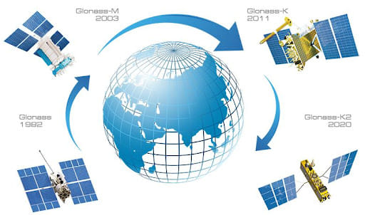
GLONASS Satellites
Architecture of GLONASS
Space Segment (SS)
- The GLONASS Space Segment, according to the GLONASS Interface Control Document, is made up of 24 satellites in three orbital planes with ascending nodes 120 degrees apart.
- Eight satellites are evenly spaced in each plane, with a 45-degree latitude displacement argument.
- The satellites are in circular orbits at an altitude of 19100-km and an inclination of 64.8 degrees, with each satellite completing the orbit in about 11 hours 15 minutes.
- The satellite spacing allows for continuous and global coverage of the terrestrial surface and near-Earth space.
Ground Segment (CS)
- The GLONASS Ground Segment consists of the System Control Centre and a network of Command and Tracking Stations spread across Russia.
- The control segment monitors the status of the GLONASS constellation, corrects orbital parameters, and uploads navigation data.
User Segment (US)
- Finally, the GLONASS User Segment is made up of user receivers that calculate coordinates, velocity, and time from GLONASS navigation signals.
Applications of GLONASS
- SPS: The Standard Positioning Service (or Standard Accuracy Signal Service) is a free service available to all users worldwide.
- PPS: The Precise Positioning Service (also known as the High Accuracy Signal Service) is only available to the military and authorised users.
- It’s commercially used to transmit weather broadcasts, communications, navigation, and reconnaissance data.
Advantages of GLONASS
- When used alone, GLONASS does not have the same level of coverage as GPS, but when both are used together, accuracy and coverage are greatly improved.
- Since GLONASS was created by Russia, it is more useful in northern latitudes.
- GLONASS has an advantage in accuracy, with up to 2 metres of accuracy.
- GPS + GLONASS allows your device to be pinpointed by a network of 55 satellites located all over the world.
- When you are in an area where GPS signals are blocked, such as between large buildings or subways, you will be accurately tracked by GLONASS satellites.
Conclusion
Nowadays, GNSS technology applications are becoming increasingly diverse. To meet user needs, the GLONASS system and user navigation equipment must be continually improved. The GLONASS system development for the benefit of increasing user requirements and the system's competitiveness is largely determined by the capabilities of the GLONASS space segment.
| Other Relevant Links | |
|---|---|
| Science & Technology Policy in India | Scientific Policy Resolution 1958 |
| Science & Technology Policy of 1983 | Science & Technology Policy of 2003 |
| Science, Technology and Innovation Policy 2013 | New Initiatives Aligned with the National Agenda |
| India and World collaboration in science projects | Technology Vision Document 2035 |
FAQs
Question: What is GLONASS?
Answer:
The Global Orbiting Navigation System (GLONASS) is a radio-based satellite navigation system developed by the former Soviet Union and now operated by the Russian Space Forces on behalf of the Russian government. It is Russia's answer to the US Global Positioning System (GPS) and the European GALILEO system. GLONASS is comprised of 21 satellites plus three spares.
Question: What are the different versions of GLONASS?
Answer:
The different versions of GLONASS are as under:
- GLONASS - These satellites were launched in 1982 for military and government use. They were designed to measure weather, positioning, timing, and velocity.
- GLONASS-M satellites were launched in 2003 to add a second civil code, which is critical for GIS mapping receivers.
- GLONASS-K - In 2011, these satellites were launched to add a third civil frequency. There are three types: K1, K2, and KM.
- GLONASS-K2 satellites will be launched after 2015 (they are currently in the design phase).
- GLONASS-KM - These satellites will be launched after 2025 (research is currently underway).
Question: What are the applications of GLONASS?
Answer:
Following are some of the applications of GLONASS:
- SPS: The Standard Positioning Service (or Standard Accuracy Signal Service) is a free service available to all users worldwide.
- PPS: The Precise Positioning Service (also known as the High Accuracy Signal Service) is only available to the military and authorised users.
- It’s commercially used to transmit weather broadcasts, communications, navigation, and reconnaissance data.
MCQs
Question: Global Navigation Satellite System (GLONASS) is operated by which of the following country?
(a) USA
(b) Russia
(c) China
(d) India
Answer: (b) See the Explanation
GLONASS stands for Globalnaya Navigazionnaya Sputnikovaya Sistema, which translates to Global Navigation Satellite System. GLONASS is Russia's version of GPS. In 1976, the Soviet Union began developing GLONASS. It is he Russian Federal Space Agency's most expensive programme, accounting for one-third of its budget in 2010. Therefore, option (b) is the correct answer.
Question: What is the Galileo Project which has been in news recently? (UPSC 2007)
(a) An intercountry programme of missile shield developed by the United States of America
(b) A project developed by India with assistance from Canada
(c) An environmental protection project being developed by Japan
(d) A multi-satellite navigation project being developed by the European Union
Answer: (d) See the Explanation
Galileo is the current global navigation satellite system (GNSS) being developed by the European Union (EU) and the European Space Agency (ESA). Therefore, option (d) is the correct answer.
Question: Which of the following pairs is/are correctly matched? (UPSC 2014)
Spacecraft Purpose
1) Cassini-Huygens: Orbiting the Venus and transmitting data to the Earth
2) Messenger: Mapping and investigating the Mercury
3) Voyager 1 and 2: Exploring the outer solar system
Select the correct answer using the code given below.
(a) 1 only
(b) 2 and 3 only
(c) 1 and 3 only
(d) 1, 2 and 3
Answer: (b) See the Explanation
Cassini-Huygens was assigned to investigate Saturn and its moons. NASA and the European Space Agency collaborated on the project. It was launched in 1997 and orbited Saturn in 2004. The mission came to an end in 2017. Hence, pair 1 is incorrect.
NASA's Messenger spacecraft was sent to map and investigate Mercury. It was launched in 2004 and entered the orbit of Mercury in 2011. The mission came to an end in 2015. Hence, pair 2 is correct.
NASA launched Voyager 1 and 2 in 1977 to explore the solar system's outer reaches. Hence, pair 3 is correct.
Therefore, option (b) is the correct answer.
Download the PREPP App and attempt FREE IAS Exam Mock Tests and get complete study material!

Full Test - 04: UPSC CSE Prelims CSAT (Paper-II)
Full Test - 03: UPSC CSE Prelims CSAT (Paper-II)
UPSC CSE Prelims 2026 GS Paper 1 Question Paper (24-May-2026)
UPSC CSE Prelims 2026 CSAT Paper 2 Question Paper (24-May-2026)

17 February 2025 | The Hindu Must Read Articles | Current Affairs

16 February 2026 | The Hindu Must Read Articles | Current Affairs

13 February 2026 | The Hindu Must Read Articles | Current Affairs









Comments