Global Positioning System (GPS) – Science & Technology Notes
The Global Positioning System (GPS) is a United States-owned utility that provides positioning, navigation, and timing (PNT) services to users. The space segment, the control segment, and the user segment comprise this system. The United States Space Force is in charge of developing, maintaining, and operating the space and control segments. In this article, we will discuss in detail regarding Global Positioning System (GPS) which will be helpful for UPSC exam preparation.
Table of Contents
Global Positioning System – Background
- In 1973, the Global Positioning System, formally known as the Navstar Global Positioning System, was launched as a joint civil/military technical programme.
- To reduce the proliferation of navigation aids, the joint programme combined the best aspects of several service-centric capabilities, including TRANSIT, TIMATION, and Project 621B.
- Until the 1980s, it was solely controlled and used by the United States government.
- The full fleet of 24 active satellites controlled by the United States did not enter service until 1994.
- GPS became appealing to a wide range of users worldwide by developing a system that overcomes the limitations of many existing navigation systems.
- GPS has been successful in virtually all navigation and timing applications, and because its capabilities are accessible using small, low-cost equipment, it is used in a wide range of applications around the world.
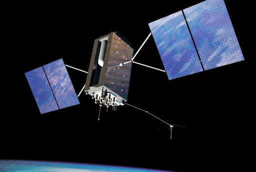
GPS Satellite
| Other Relevant Links | |
|---|---|
| GSLV and Various Engine | Recent National and International Space Missions |
| Cryogenic rockets | Scramjet Engine |
| GSLV Mk III-D1 OR GSAT-19 Mission | ISRO’s World Record PSLV C37 Launch |
| Galileo | GLONASS |
| IRNSS | GAGAN |
| Chandrayaan – I & II | Mars Orbiter Mission |
What is Global Positioning System (GPS)?
- The Global Positioning System (GPS) is a radio-navigation system based in space that consists of a constellation of satellites that broadcast navigation signals and a network of ground stations and satellite control stations that monitor and control the system.
- Currently, 31 GPS satellites orbit the Earth at an altitude of about 11,000 miles, providing users with accurate position, velocity, and time information anywhere in the world and in all weather conditions.
- GPS is comprised of three components: satellites, ground stations, and receivers.
- Satellites function similarly to stars in constellations in that we know where they are supposed to be at any given time.
- The ground stations monitor and control the satellites, as well as assist in determining their locations—both where they were and where they are expected to be.
- A receiver, similar to the one found in your phone or car, is constantly listening for signals from these satellites, which can be used as a giant tape measure between the receiver and the satellites.
- Your receiver knows exactly where you are once it calculates its distance from four or more satellites.
- Your location on the ground can be determined with incredible precision in seconds from thousands of miles up in space, often within a few yards of your actual location.
- Because the US government owns the GPS satellite system and can selectively deny or limit network access, other countries have developed their own GPS satellite networks. These are some examples:
- BeiDou Navigation Satellite System - China
- Global Orbiting Navigation Satellite System (GLONASS) - Russia
- Galileo positioning system – Europe Union
- Indian Regional Navigation Satellite System (IRNSS), also known as NAVIC - India
What is Global Navigation Satellite Systems (GNSS)?
|
Segments of GPS
Space Segment
- The GPS space segment is made up of a constellation of satellites that send radio signals to users.
- The United States is committed to keeping at least 24 operational GPS satellites operational 95% of the time.
- GPS satellites operate at an altitude of approximately 20,200 km (12,550 miles) in medium Earth orbit (MEO). Each satellite makes two daily orbits around the Earth. Because of the high altitude, the signals can cover a larger area.
- The satellites' orbits are designed so that a GPS receiver on Earth can always receive a signal from at least four satellites at any given time.
- Each satellite sends out low radio signals with a unique code on different frequencies, which the GPS receiver recognises.
- The primary function of these coded signals is to calculate travel time from the satellite to the GPS receiver.
- The distance between the satellite and the GPS receiver is equal to the travel time multiplied by the speed of light. Because these are low-power signals that cannot pass through solid objects, a clear view of the sky is required.
Control Segment
- The GPS control segment is made up of a global network of ground stations that track GPS satellites, monitor their transmissions, conduct analyses, and send commands and data to the constellation.
- A master control station, an alternate master control station, 11 command and control antennas, and 16 monitoring sites comprise the current Operational Control Segment (OCS).
- The control segment follows the satellites and corrects their orbital and time information. Four unmanned control stations and one master control station comprise the control segment.
- The four unmanned stations receive data from the satellites and send it to the master control station, which corrects it before sending it back to the GPS satellites.
User Segment
- The user segment consists of the GPS receiver equipment, which receives the signals from the GPS satellites and uses the transmitted information to calculate the user’s three-dimensional position and time.
How Does GPS Work?
- When a GPS receiver is turned on, it first downloads all of the satellites' orbit information. This process can take up to 12.5 minutes the first time, but once completed, the information is saved in the receiver's memory for future use.
- Even though the GPS receiver knows the precise location of the satellites in space, it must also know the distance between each satellite from which it receives a signal.
- The receiver calculates the distance by multiplying the velocity of the transmitted signal by the time it takes for the signal to reach the receiver. The velocity is already known to the receiver: it is the speed of a radio wave, or 186,000 miles per second (the speed of light).
- To calculate the time component of the formula, the receiver compares the satellite's transmitted code to its own code and determines how much it needs to delay its code to match the satellite's code. The distance is calculated by multiplying the delayed time by the speed of light.
- Because the GPS receiver's clock is less accurate than the satellite's atomic clock, each distance measurement must be corrected to account for the GPS receiver's internal clock error.
- Once the satellite and position of at least four satellites are known, the receiver can calculate a position using trilateration.
- Trilateration is a mathematical technique used by a GPS device to determine the user's position, speed, and elevation.
- A GPS device can calculate the precise distance or range to each satellite being tracked by constantly receiving and analysing radio signals from multiple GPS satellites and applying the geometry of circles, spheres, and triangles.
- All GPS devices require three satellites to calculate position accurately. Data from a fourth satellite—or even more than four satellites—improves the precision of the point's location and allows for the calculation of factors such as elevation or, in the case of aircraft, altitude.
- GPS receivers routinely track four to seven satellites at the same time and analyse the data using trilateration.
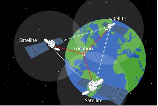
Trilateration
How Accurate is GPS?
- GPS satellites broadcast their signals in space with some accuracy, but what you receive is determined by other factors such as satellite geometry, signal blockage, atmospheric conditions, and receiver design features/quality.
- GPS-enabled smartphones, for example, are typically accurate to within 4.9 m (16 ft.) under open sky. Their accuracy, however, degrades near buildings, bridges, and trees.
- Many factors can reduce GPS positioning accuracy. The following are some of the most common causes:
- Buildings, bridges, and trees, among other things, can block satellite signals
- Using indoors or underground
- Signals reflected off buildings or walls (referred to as "multipath")
- Less common causes could include:
- Jamming or radio interference
- Massive solar storms
- Satellite maintenance/manoeuvres cause temporary coverage gaps
- Inadequately designed devices that do not meet GPS Interface Specifications
- In many cases, a device's GPS hardware is functional, but its mapping software is defective. Users, for example, are frequently misled by:
- Maps that have been drawn incorrectly
- Mislabeled businesses
- Roads, buildings, communities, and so on are all missing
- Street addresses that were incorrectly estimated
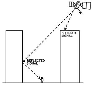
Signals reflected off buildings or walls
Global Positioning System (GPS) – Applications
- There are five major categories of Global Positioning System applications:
- Location - determining a position
- Tracking - monitoring object or personal movement
- Navigation - getting from one location to another
- Mapping - It is the process of creating world maps
- Timing - providing the world with precise timing
- GPS, like the Internet, is a critical component of the global information infrastructure.
- Because GPS is free, open, and dependable, it has spawned hundreds of applications that touch every aspect of modern life.
- GPS technology can now be found in everything from cell phones and wristwatches to bulldozers, shipping containers, and ATM machines.
- GPS increases productivity in a wide range of industries, including farming, construction, mining, surveying, package delivery, and logistical supply chain management.
- GPS is critical for precise time synchronisation in major communications networks, banking systems, financial markets, and power grids. Some wireless services are unable to function without it.
- GPS saves lives by reducing traffic accidents, assisting in search and rescue efforts, and expediting the delivery of emergency services and disaster relief.
- GPS is critical to the Next Generation Air Transportation System (NextGen), which will increase airspace capacity while improving flight safety.
- GPS also helps scientists with weather forecasting, earthquake monitoring, and environmental protection.
Future of GPS
- Countries continue to develop and improve their GPS systems. Efforts are being made all over the world to improve accuracy, reliability, and GPS capabilities.
- GNSS receivers are expected to become smaller, more accurate, and more efficient, allowing GNSS technology to penetrate even the most cost-sensitive GPS applications.
- Scientists and rescue workers are developing novel applications for GPS technology in natural disaster prevention and analysis, such as in the event of an earthquake, volcanic eruption, sinkhole, or avalanche.
- In order to slow the spread of the COVID-19 pandemic, researchers are considering using mobile location data to assist with contact tracing.
- The launch of new GPS III satellites will improve GPS accuracy to 1-3 metres, improve navigation capabilities, and provide longer-lasting components.
- The next generation of GPS satellites will have improved signal protection, will be less susceptible to signal jamming, and will be more manoeuvrable to cover dead zones.
- The National Aeronautics and Space Administration's (NASA) Deep Space Atomic Clock is set to use a powerful onboard GPS satellite to help future astronauts embarking on deep space journeys have better time consistency.
- GPS tracking in the future will most likely be far more accurate and effective for both personal and commercial use.
Conclusion
For thousands of years, humans relied on the stars to guide them. Sailors navigated to distant shores by using the constellations, sun, and moon. All that is required nowadays is a GPS receiver. It tells us where we are and where we are going on Earth. GPS technology has numerous applications ranging from mining to aviation, agriculture to marine, recreation to defence. GPS systems are now used by everyone from doctors, scientists, farmers, soldiers, pilots, hikers, delivery drivers, sailors, fishermen, dispatchers, athletes, and people from all walks of life to make their work more productive, safer, and easier.
| Other Relevant Links | |
|---|---|
| Science & Technology Policy in India | Scientific Policy Resolution 1958 |
| Science & Technology Policy of 1983 | Science & Technology Policy of 2003 |
| Science, Technology and Innovation Policy 2013 | New Initiatives Aligned with the National Agenda |
| India and World collaboration in science projects | Technology Vision Document 2035 |
FAQs
Question: What is the Global Positioning System (GPS)?
Answer: The Global Positioning System (GPS) is a satellite-based navigation system that allows users to determine their exact location (latitude, longitude, and altitude) anywhere on Earth. It operates using a network of at least 24 satellites orbiting the Earth, ground stations that monitor the satellites, and GPS receivers that collect the satellite signals. GPS is widely used for navigation, mapping, and tracking in various applications, such as in cars, smartphones, aviation, and maritime systems.
Question: How does GPS work?
Answer: GPS works by using a system of satellites that orbit the Earth. These satellites constantly transmit signals containing information about their position and the time the signal was sent. GPS receivers on the ground receive signals from at least four satellites and use the time delay between signal transmission and reception to calculate the distance to each satellite. By triangulating these distances, the GPS receiver determines the user’s exact location, including altitude.
Question: What are the key components of the GPS system?
Answer: The key components of the GPS system include:
- Space Segment: Composed of at least 24 satellites that transmit signals from space.
- Control Segment: Ground stations that track and monitor the satellites to ensure their proper functioning.
- User Segment: GPS receivers used by individuals and systems to determine their location.
Question: What are the applications of GPS technology?
Answer: GPS technology has a wide range of applications, including:
- Navigation: Used in cars, airplanes, and smartphones for turn-by-turn directions.
- Mapping: Enables accurate mapping and surveying, essential for urban planning, construction, and resource management.
- Tracking: Used in logistics, shipping, and wildlife monitoring to track the movement of goods or animals.
- Military and Defense: Provides precise targeting and positioning capabilities for military operations.
Question: What are the limitations of GPS technology?
Answer: Despite its widespread use, GPS has certain limitations:
- Signal Blockage: GPS signals can be blocked by tall buildings, dense forests, or underground environments.
- Accuracy: The accuracy of GPS can be affected by factors such as atmospheric conditions, interference, or multi-path errors.
- Dependence on Satellites: GPS is reliant on the functioning of satellites, and any failure in satellite systems could disrupt services.
- Security Concerns: GPS signals can be jammed or spoofed, leading to security risks in critical sectors like defense and aviation.
MCQs
1. How many satellites are generally required for a GPS receiver to determine its location accurately?
A) 3
B) 4
C) 5
D) 6
Answer: (B) See the Explanation
Explanation: A GPS receiver requires signals from at least four satellites to accurately determine its position, including latitude, longitude, and altitude.
2. What component of the GPS system is responsible for monitoring the satellites?
A) Control Segment
B) Space Segment
C) User Segment
D) Ground Segment
Answer: (A) See the Explanation
Explanation: The Control Segment of the GPS system includes ground stations that monitor and manage the operational status of the satellites in orbit.
3. Which of the following is not an application of GPS?
A) Navigation
B) Mapping
C) Social Media
D) Tracking
Answer: (C) See the Explanation
Explanation: While GPS is used for navigation, mapping, and tracking, it is not directly involved in social media activities. Social media applications use GPS for location tagging, but GPS itself does not have a role in social media functions.
4. Which of the following factors does NOT affect GPS accuracy?
A) Satellite failure
B) Atmospheric conditions
C) Signal interference
D) Cloud cover
Answer: (D) See the Explanation
Explanation: GPS accuracy can be affected by satellite failure, atmospheric conditions, and signal interference, but cloud cover typically does not impact GPS performance significantly.
5. What is the main limitation of GPS technology?
A) Limited coverage
B) Signal blockage in certain environments
C) High cost of receivers
D) Inaccurate location data
Answer: (B) See the Explanation
Explanation: A major limitation of GPS technology is signal blockage, which occurs in environments like urban canyons, dense forests, or underground locations, where GPS signals are obstructed.
GS Mains Questions and Model Answers
Q1: Analyze the significance of GPS technology in modern navigation and its impact on various industries.
Answer: GPS technology has revolutionized navigation by providing accurate and real-time location information. It has become an essential tool for industries such as transportation, logistics, aviation, and shipping. GPS-enabled systems allow for efficient route planning, fleet management, and real-time tracking of goods and vehicles, reducing operational costs and improving service delivery. In aviation, GPS has enhanced flight safety by providing accurate positioning for navigation and landing. The military also uses GPS for precision targeting and positioning. Furthermore, GPS is widely used in smartphones, enabling location-based services like navigation apps, weather forecasts, and social media location tagging. The widespread adoption of GPS technology has improved efficiency, safety, and connectivity across multiple sectors.
Q2: How does GPS contribute to scientific research, particularly in the fields of geophysics and environmental monitoring?
Answer: GPS technology plays a crucial role in scientific research, especially in geophysics and environmental monitoring. In geophysics, GPS is used to monitor tectonic plate movements, measure the rate of continental drift, and study seismic activity. GPS data can help scientists understand the Earth's crust and how it deforms over time, providing insights into earthquake prediction and volcanic activity. In environmental monitoring, GPS helps track and manage natural resources, monitor deforestation, and study changes in ecosystems due to climate change. GPS-enabled sensors are also used in environmental studies to monitor air quality, water levels, and soil conditions, helping researchers assess environmental changes in real-time and formulate effective conservation strategies.
Q3: Evaluate the challenges and opportunities associated with the future of GPS technology in the era of autonomous vehicles.
Answer: The future of GPS technology holds significant promise, particularly with the rise of autonomous vehicles. GPS is crucial for self-driving cars as it allows them to navigate safely and accurately in real-time. However, challenges remain, such as GPS signal interference, urban canyon effects, and the need for more accurate location data in dense environments. Additionally, reliance on GPS for autonomous vehicles raises concerns about security, as GPS signals can be jammed or spoofed, posing risks to vehicle safety. To address these challenges, complementary technologies such as lidar, radar, and computer vision will be integrated with GPS to provide a more robust navigation system for autonomous vehicles. The opportunity lies in refining GPS technology to enhance its accuracy and resilience, ensuring that autonomous vehicles can navigate safely in any environment, fostering innovation in transportation, and leading to safer, more efficient travel systems in the future.
Previous Year Questions on GPS
1. UPSC CSE Prelims 2020:
Question: Which of the following is NOT a function of GPS?
A) Navigation
B) Location tracking
C) Weather forecasting
D) Mapping
Answer: (C)
Explanation: GPS is used for navigation, tracking, and mapping, but it does not directly forecast weather. Weather forecasting requires different technology such as meteorological satellites and ground-based data.
2. UPSC CSE Mains 2019 (GS Paper 3):
Question: "Discuss the role of GPS in enhancing national security and defense systems in India."
Answer: GPS plays a critical role in national security and defense by providing accurate positioning and navigation for military operations, including troop movements, artillery targeting, and air defense systems. In India, GPS is used to enhance the effectiveness of the armed forces, ensuring that military operations are carried out with precision and efficiency. GPS also supports the surveillance and monitoring of borders, helping to track movement along sensitive areas. Furthermore, GPS is integrated into India's missile defense systems, aiding in the guidance and accuracy of missiles. However, the system’s vulnerability to jamming and spoofing poses security risks, necessitating the development of more secure, resistant navigation technologies.
Download the PREPP App and attempt FREE IAS Exam Mock Tests and get complete study material!

Full Test - 04: UPSC CSE Prelims CSAT (Paper-II)
Full Test - 03: UPSC CSE Prelims CSAT (Paper-II)
UPSC CSE Prelims 2026 GS Paper 1 Question Paper (24-May-2026)
UPSC CSE Prelims 2026 CSAT Paper 2 Question Paper (24-May-2026)

17 February 2025 | The Hindu Must Read Articles | Current Affairs

16 February 2026 | The Hindu Must Read Articles | Current Affairs

13 February 2026 | The Hindu Must Read Articles | Current Affairs









Comments