GAGAN: GPS Aided Geo Augmented Navigation – Science & Technology Notes
GPS Aided Geo Augmented Navigation (GAGAN) is a Space Based Augmentation System (SBAS) developed jointly by ISRO and AAI to provide the best possible navigational services over the Indian FIR (Flight Information Region), with the ability to expand to neighbouring FIRs. GAGAN is a satellite and ground station network that provides GPS signal corrections to improve position accuracy. In this article, we will discuss in detail regarding GAGAN which will be helpful for UPSC exam preparation.
Table of Contents
What is GAGAN?
- GPS Aided Geo Augmented Navigation (GAGAN) is a Satellite Based Augmentation System (SBAS) that was developed in collaboration with the Airport Authority of India (AAI).
- The primary goals of GAGAN are to provide satellite-based navigation services with the accuracy and integrity required for civil aviation applications, as well as to improve air traffic management in Indian airspace.
- The system will be compatible with other international SBAS systems and will allow for seamless navigation across regional borders.
- The first GAGAN navigation payload was launched on GSAT-8 on May 21, 2011, and the second on GSAT-10 on September 29, 2012.
- GAGAN Payload is already operational on satellites GSAT-8, GSAT-10, and GSAT-15.
- GAGAN adds accuracy, availability, and integrity to all phases of flight, from en route to approach, for all qualified airports within the GAGAN service volume.
- After the United States, Europe, and Japan, India is the fourth country in the world to take on the challenge of establishing a regional SBAS that will redefine navigation over India and adjacent regions.
- The GAGAN GEO footprint extends from Africa to Australia, and the GAGAN system can accommodate 45 reference stations for future expansion to neighbouring countries.
- Furthermore, with its unique IONO algorithm designed and developed by URSC in collaboration with the vendor, GAGAN is the first system in the world to be certified to serve the equatorial anomaly region.
| Other Relevant Links | |
|---|---|
| GSLV and Various Engine | Recent National and International Space Missions |
| Cryogenic rockets | Scramjet Engine |
| GSLV Mk III-D1 OR GSAT-19 Mission | ISRO’s World Record PSLV C37 Launch |
| Global Positioning System | Galileo |
| GLONASS | IRNSS |
| Chandrayaan – I & II | Mars Orbiter Mission |
Working of GAGAN
- The GAGAN employs a network of ground stations to supplement the GPS standard positioning service (SPS) navigation signal.
- To collect GPS satellite data, a network of precisely surveyed ground reference stations, Indian Reference Stations (INRES) is strategically positioned across the country.
- The master control centre, Indian Master Control Centre (INMCC) generates messages based on this information to correct any signal errors.
- These correction messages are then uplinked via the Indian Land Uplink Station (INLUS) and broadcast via geostationary communication satellites to receivers onboard aircraft using the same frequency as GPS.
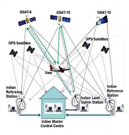
Working of GAGAN
Architecture of GAGAN
Space Segment
- Three operational geostationary satellites:
- GSAT-8: It was launched in March 2011.
- GSAT-10: It was launched in April 2012.
- GSAT-15: It was launched in November 2015.
Ground Segment
- GPS data is received and processed on the ground at 15 Indian Reference Stations (INRES) located in Ahmedabad, Bangalore, Bhubaneswar, Kolkata, Delhi, Dibrugarh, Gaya, Goa, Guwahati, Jaisalmer, Jammu, Nagpur, Porbandar, Port Blair, and Trivandrum (out of a total of 45).
- The Indian Master Control Centre (INMCC), which has two operational sites in Bangalore and Delhi, processes data from the INRESs to compute differential corrections and estimate its level of integrity.
- The SBAS message generated by the two INMCC is transmitted to the GEO satellites via the Indian Land Uplink Station (INLUS).
User Segment
- GAGAN-enabled GPS receivers, which use the same technology as WAAS receivers and can use the GAGAN Signal-in-Space (SIS).
- Civil aviation user equipment must be certified against a number of standards.
- Raytheon was awarded the contract to modernise India's air navigation system in 2009.
- Raytheon was in charge of building the Ground Stations, which were supplied by some ISRO ground equipment.
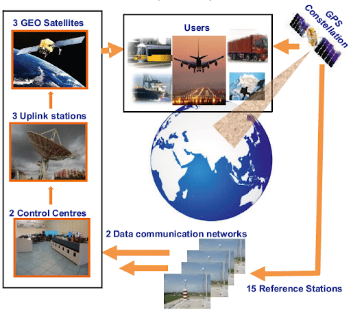
GAGAN Operational System
Applications of GAGAN
- Accurate and dependable satellite navigation services are required for civil aviation applications over Indian airspace.
- Improved Air Traffic Management in Indian Airspace.
- Signalling underIndian Railways.
- Road Asset Management System (RAMS).
- Managed traffic in real time in order to avoid traffic jams.
- Natural Resources, Forest, and Land Management Using GPS SXTREO-T51
- Forest Management.
- Scientific Research for Atmospheric Studies Using Mobile, Tourism, Aviation, and Other Applications.
- GAGAN significantly improves GPS accuracy.
- Navigation and safety improvements in civil aviation, railways, ships, and spacecraft, among other things.
- Obtaining Geographic Data.
- Location-based services.
Advantages of GAGAN
- GAGAN provides nearly the same accuracy as a ground-based landing system, which consists of antennae and beacons that transmit signals to aircraft to assist pilots in landing.
- It will allow aircraft to land at smaller and regional airports that do not have expensive ground-based landing systems.
- GAGAN can save fuel and equipment costs, improve flight safety, especially in bad weather, and increase air space capacity.
- Once fully implemented, it will allow compliant aircraft to land in low-visibility scenarios at several smaller airports, including those in the North East.
- In poor weather and low visibility conditions, this new technology provides a significant operational benefit.
- Aircraft can reap the most benefits in terms of improved landing safety, reduced fuel consumption, fewer delays, diversions, and cancellations, and so on.
- AAI, in collaboration with the Indian National Centre for Ocean Information Services (INCOIS), has implemented the GAGAN Message Service (GMS), which will send alert messages to fishermen, farmers, and disaster-affected people in the event of natural disasters or calamities such as floods or earthquakes.
- GAGAN's additional capabilities are also being investigated for use in non-aviation fields such as railways, surveying, agriculture, the power sector, mining, and so on.
- While GAGAN is primarily intended for aviation, it will also benefit intelligent transportation, maritime, highways, railways, security agencies, telecom, etc.
Conclusion
GAGAN will enable more accurate position reporting, allowing for more uniform and high-quality Air Traffic Management (ATM). Furthermore, GAGAN will benefit all modes of transportation, including maritime, highways, railroads, and public services such as defence services, security agencies, the telecom industry, and personal users of position location applications, in addition to aviation.
| Other Relevant Links | |
|---|---|
| Science & Technology Policy in India | Scientific Policy Resolution 1958 |
| Science & Technology Policy of 1983 | Science & Technology Policy of 2003 |
| Science, Technology and Innovation Policy 2013 | New Initiatives Aligned with the National Agenda |
| India and World collaboration in science projects | Technology Vision Document 2035 |
FAQs
Question: What is GAGAN?
Answer: GAGAN (GPS Aided Geo-Augmented Navigation) is an indigenous satellite-based augmentation system developed by ISRO and AAI to improve the accuracy and reliability of GPS for aviation and other sectors.
Question: What is the main purpose of GAGAN?
Answer: The main purpose of GAGAN is to provide accurate navigation signals to improve the safety, efficiency, and reliability of air navigation, primarily in the Indian airspace.
Question: Which agencies developed GAGAN?
Answer: GAGAN was developed jointly by the Indian Space Research Organisation (ISRO) and the Airports Authority of India (AAI).
Question: How does GAGAN improve GPS accuracy?
Answer: GAGAN improves GPS accuracy by enhancing the signals received from GPS satellites through ground-based reference stations, providing more precise location information, especially in aviation.
Question: What sectors can benefit from GAGAN?
Answer: Sectors like aviation, transportation, agriculture, and disaster management can benefit from GAGAN's enhanced navigation and positioning accuracy for various applications.
MCQs
1. What does GAGAN stand for?
A) Global Augmented Geographical Navigation
B) GPS Aided Geo-Augmented Navigation
C) Global Aviation GPS Augmentation Network
D) Geospatial Assistance for Navigation
Answer: (B) See the Explanation
Explanation: GAGAN stands for GPS Aided Geo-Augmented Navigation, an Indian satellite-based navigation system developed to enhance GPS accuracy, primarily for aviation.
2. Which agencies are responsible for the development of GAGAN?
A) NASA and ISRO
B) ISRO and AAI
C) AAI and DRDO
D) NASA and AAI
Answer: (B) See the Explanation
Explanation: GAGAN was developed jointly by the Indian Space Research Organisation (ISRO) and the Airports Authority of India (AAI) to improve navigation accuracy.
3. What is the main purpose of GAGAN?
A) To improve mobile communication
B) To enhance GPS accuracy for aviation and other sectors
C) To provide weather data to satellites
D) To track global climatic patterns
Answer: (B) See the Explanation
Explanation: GAGAN is designed to improve GPS accuracy, primarily to enhance aviation navigation systems and also benefit other sectors like agriculture and disaster management.
4. How does GAGAN improve GPS signals?
A) By providing direct satellite communication
B) By enhancing GPS signals through ground-based stations
C) By using new satellite constellations
D) By using a single satellite for navigation
Answer: (B) See the Explanation
Explanation: GAGAN improves GPS accuracy by using ground-based reference stations to enhance the signals received from GPS satellites, providing more accurate location information.
5. Which of the following sectors can benefit from GAGAN?
A) Aviation
B) Transportation
C) Agriculture
D) All of the above
Answer: (D) See the Explanation
Explanation: GAGAN can benefit multiple sectors, including aviation, transportation, agriculture, and disaster management, by providing enhanced navigation and positioning accuracy.
GS Mains Questions and Model Answers
Q1: Discuss the significance of GAGAN in improving the navigation systems in India, particularly in the context of aviation.
Answer: GAGAN, or GPS Aided Geo-Augmented Navigation, is a satellite-based augmentation system that significantly enhances the accuracy of GPS signals, especially in aviation. It improves the safety and efficiency of air navigation by providing precise location information for aircraft, reducing the risk of accidents due to navigation errors. GAGAN also supports precision approaches at airports, contributing to the reduction in delays and the optimization of flight routes. By improving the quality of navigation data, GAGAN allows better management of airspace, enhances the efficiency of air traffic control, and enables the use of satellite-based navigation for aircraft landing, even at remote airports. This indigenous development strengthens India’s technological capabilities and ensures self-reliance in critical sectors like aviation, fostering economic growth and boosting India’s global standing in space and technology.
Q2: How can GAGAN contribute to sectors other than aviation, such as agriculture and disaster management?
Answer: While GAGAN was primarily developed for aviation, its high-precision satellite-based navigation system has far-reaching applications across multiple sectors. In agriculture, GAGAN can be used for precision farming, helping farmers optimize land use, reduce waste, and improve crop yields by providing accurate information on soil health, irrigation, and crop monitoring. In disaster management, GAGAN enables better planning and coordination by providing real-time data on weather patterns, flood zones, and disaster-prone areas. It also aids in rapid response operations by providing accurate location data for emergency services, rescuers, and relief operations. By ensuring accurate and reliable positioning data, GAGAN plays a vital role in improving operational efficiencies and mitigating risks in various non-aviation sectors.
Q3: Explain the technological aspects of GAGAN and its role in enhancing India's space capabilities.
Answer: GAGAN is a significant technological development that enhances India’s space capabilities. It works by augmenting the signals received from GPS satellites through ground-based reference stations that correct errors in the satellite signals. This system uses multiple geostationary satellites to provide coverage and increase the reliability and accuracy of GPS signals in India and surrounding regions. GAGAN’s precision approach system (PA) enables accurate and safe navigation for aircraft, reducing reliance on ground-based infrastructure. Technologically, GAGAN demonstrates India’s growing self-reliance in space-based navigation systems, positioning ISRO as a leader in space technology. It strengthens India’s aerospace infrastructure, enabling the country to develop more sophisticated space-based applications, ranging from navigation to communication, weather forecasting, and disaster management, contributing to India’s global technological influence.
Previous Year Questions on GAGAN
1. UPSC CSE Mains 2020 (GS Paper 3):
Question: "What is GAGAN, and how does it contribute to the enhancement of air navigation in India?"
Answer: GAGAN, or GPS Aided Geo-Augmented Navigation, is a satellite-based augmentation system developed by ISRO and AAI. It improves the accuracy of GPS signals to aid air navigation. By enhancing the precision of aircraft positioning, GAGAN contributes to the safe and efficient management of air traffic, facilitates satellite-based precision landings, and reduces the dependence on ground-based navigation aids. GAGAN plays a crucial role in optimizing flight routes, reducing delays, and improving the overall efficiency of aviation in India.
2. UPSC CSE Mains 2019 (GS Paper 3):
Question: "Discuss the technological innovations in India’s space sector and their impact on national security and development."
Answer: India's space sector has seen numerous innovations, including the development of GAGAN, Mangalyaan, and the Chandrayaan missions. GAGAN, in particular, has enhanced national security by improving navigation systems for defense and aviation. Technological advancements like GAGAN contribute to better air traffic management, disaster prediction, and military surveillance. These innovations support both civil and defense sectors, enabling India to stay ahead in the global space race while ensuring self-reliance in strategic technologies. Furthermore, India's space technology aids in enhancing communication, weather forecasting, and scientific research, contributing significantly to national development.
Download the PREPP App and attempt FREE IAS Exam Mock Tests and get complete study material!

Full Test - 04: UPSC CSE Prelims CSAT (Paper-II)
Full Test - 03: UPSC CSE Prelims CSAT (Paper-II)
UPSC CSE Prelims 2026 GS Paper 1 Question Paper (24-May-2026)
UPSC CSE Prelims 2026 CSAT Paper 2 Question Paper (24-May-2026)

17 February 2025 | The Hindu Must Read Articles | Current Affairs

16 February 2026 | The Hindu Must Read Articles | Current Affairs

13 February 2026 | The Hindu Must Read Articles | Current Affairs









Comments