Ancient Landscape Cut by Rivers Found Deep Under Antarctic Ice
Primary Source: The Hindu
Prepp Prelims Booster: Antarctica's location, Gondwana supercontinent, Plate tectonics
Prepp Mains Booster: Salient features of World’s Physical Geography, Geographical features and their location, Changes in critical geographical features (including water-bodies and ice-caps)
Why in the news?
- Recently, Scientists have discovered a vast ancient landscape beneath the Antarctic ice, suggesting that the continent was once home to rivers and forests.
- Using satellite observations and ice-penetrating radar, this landscape, found in East Antarctica’s Wilkes Land region, appears to be from a period ranging from 14 million to over 34 million years ago.
Table of Contents
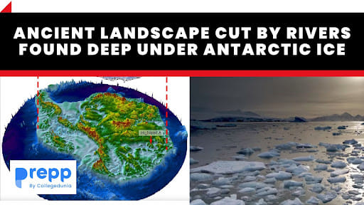
Formation of Antarctica
|
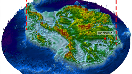
An illustration of the ancient landscape found under Antarctic Ice
Location and Size of the Landscape
- The ancient landscape discovered beneath the Antarctic ice is located in East Antarctica’s Wilkes Land region, which borders the Indian Ocean.
- The size of this landscape covers an area roughly equivalent to Belgium or the U.S. state of Maryland.
Historical Significance of the Landscape
- Evidence of a Warmer Antarctica: The discovery provides concrete evidence that Antarctica was not always a frozen continent. The existence of valleys and ridges shaped by rivers, along with the mention of ancient palm tree pollen found nearby, suggests that this region once experienced warmer climates, possibly ranging from conditions similar to today's Patagonia to even more tropical climates.
- Insight into Geological Timescales: The landscape is believed to date from at least 14 million years ago and could extend beyond 34 million years ago. This timeline provides insights into the major climatic and geological transitions Antarctica underwent, from a time when it supported rivers and forests to its eventual deep freeze.
- Understanding Earth’s Geographical Evolution: Antarctica was once part of the Gondwana supercontinent, which also included present-day regions such as Africa, South America, Australia, the Indian subcontinent, and the Arabian Peninsula. Over time, through the process of plate tectonics, Antarctica split off and became isolated. The ancient landscape, with its rivers flowing toward a continental coastline, offers glimpses into the continent's topography and hydrology during these transitional phases.
- Indications of Past Life: While the region's fossil record is currently too incomplete to precisely indicate which animals might have inhabited it, the warmer conditions suggest that it would have supported a diverse range of wildlife.
Features of the Ancient Landscape
- Valleys and Ridges: The landscape consists of valleys and ridges. These formations were apparently shaped by rivers before the region was engulfed by glaciation.
- Size and Location: The landscape is situated in East Antarctica’s Wilkes Land region, bordering the Indian Ocean. It covers an area roughly the size of Belgium or the U.S. state of Maryland.
- Age: The researchers believe the landscape dates back to at least 14 million years ago and might extend beyond 34 million years ago, a period before Antarctica entered its deep freeze phase.
- Ice Thickness: The ice sheet covering this ancient landscape is about 2.2 to 3 km thick.
- Modification by Various Processes: The landscape has been influenced and modified by different processes over a vast geological timeframe, including the actions of rivers, tectonic movements, and glaciation.
- Evidences of Warmer Climates: Clues like ancient palm tree pollen found in the vicinity support this claim. Depending on how far back in time one goes, the climate of this region might have varied from conditions resembling present-day Patagonia to possibly something more tropical.
- Possible Wildlife and Flora: While the exact details of the wildlife and flora that might have existed there are not known due to an incomplete fossil record, the warmer conditions of the past indicate that this area likely supported diverse life forms.
- Preservation Under Ice: The landscape has remained preserved beneath the ice for potentially up to 34 million years. It acts as a snapshot of the past, capturing a time before the vast ice sheets formed and covered the entire continent.
Research Methodologies Used
- Satellite Observations: The researchers employed satellite observations of the ice surface. In some places, the contours of the ice surface mimicked the buried landscape underneath, providing indications of the landforms below.
- Ice-Penetrating Radar: Ice-penetrating radar data was collected from a plane flying over the site. This radar can penetrate the ice and provide data about the structures and topography beneath it.
Future Explorations Planned
Drilling Through the Ice
- The researchers have mentioned the potential to drill through the ice to obtain core samples of sediments below the surface.
- This process could help in revealing evidence about the ancient flora and fauna that once existed in the region.
- Drilling and obtaining core samples could be analogous to previous studies conducted in places like Greenland where samples dated back 2 million years.
Detailed Study of the Landscape
- While the current discovery provides a broad overview, there is potential for more in-depth studies to further explore and map the intricacies of the ancient landscape.
- This could include a more detailed understanding of its geology, hydrology, and possible past ecosystems.
Comparison with Other Discoveries
- Some previous studies have revealed ancient landscapes beneath Antarctica's ice, including mountains and highlands.
- The researchers might undertake comparative studies between this new discovery and previous ones to better understand the geological evolution of Antarctica.
Conclusion
Ancient landscape discovered provides significant insights into Antarctica's history before its deep freeze. This preserved landscape has been under ice for likely 34 million years. Further research and drilling could unlock more secrets of the continent's ancient past.
(*Click this link to read prelims specific weekly current affairs articles)
FAQs
Question: Is there land under the ice in Antarctica?
Answer:
The Antarctic continent is spread across a wide landmass. Mountains and valleys can be found beneath the smooth ice sheet.
Question: Which research methodologies have been used to study the landscape?
Answer:
The research methodologies used were:
- Satellite Observations: The researchers employed satellite observations of the ice surface. In some places, the contours of the ice surface mimicked the buried landscape underneath, providing indications of the landforms below.
- Ice-Penetrating Radar: Ice-penetrating radar data was collected from a plane flying over the site. This radar can penetrate the ice and provide data about the structures and topography beneath it.
Question: What is the location of the ancient landscape discovered under Antarctic Ice?
Answer:
The ancient landscape discovered beneath the Antarctic ice is located in East Antarctica’s Wilkes Land region, which borders the Indian Ocean. The size of this landscape covers an area roughly equivalent to Belgium or the U.S. state of Maryland.
MCQs
Question: The formation of the Ozone hole in the Antarctic region has been a cause of concern. What could be the reason for the formation of this hole? (UPSC 2011)
(a) Presence of prominent tropospheric turbulence; and inflow of chlorofluorocarbons
(b) Presence of prominent polar front and stratospheric clouds; and inflow of chlorofluorocarbons
(c) Absence of polar front and stratospheric clouds; and inflow of methane and chlorofluorocarbons.
(d) Increased temperature at polar region due to global warming
Answer: (b) See the Explanation
In the 1980s, atmospheric scientists working in Antarctica detected ozone layer depletion known as the ozone hole over the South Pole. The ozone hole was discovered to be caused by a unique set of variables. In the summer, nitrogen dioxide and methane mix with chlorine monoxide and chlorine atoms to produce chlorine sinks, avoiding significant ozone depletion, whereas in the winter, polar stratospheric clouds accumulate over Antarctica. These polar stratospheric clouds provide a surface for the hydrolysis of chlorine nitrate to create hypochlorous acid. It also interacts with the hydrogen chloride to make molecular chlorine. When sunlight returns to Antarctica in the spring, the warmth of the sun breaks apart the clouds and photolyzes HOCl and Cl2. As previously established, the chlorine radicals generated commence the chain reaction for ozone depletion.
Therefore, option (b) is the correct answer.
Question: What supercontinent was Antarctica once a part of?
(a) Laurasia
(b) Pangaea
(c) Gondwana
(d) Rodinia
Answer: (c) See the Explanation
Antarctica was once part of the Gondwana supercontinent, which also included other regions such as Africa, South America, Australia, the Indian subcontinent, and the Arabian Peninsula.
Therefore, option (c) is the correct answer.
Download the PREPP App and attempt FREE IAS Exam Mock Tests and get complete study material!

Full Test - 04: UPSC CSE Prelims CSAT (Paper-II)
Full Test - 03: UPSC CSE Prelims CSAT (Paper-II)
UPSC CSE Prelims 2026 GS Paper 1 Question Paper (24-May-2026)
UPSC CSE Prelims 2026 CSAT Paper 2 Question Paper (24-May-2026)

17 February 2025 | The Hindu Must Read Articles | Current Affairs

16 February 2026 | The Hindu Must Read Articles | Current Affairs

13 February 2026 | The Hindu Must Read Articles | Current Affairs









Comments