
Question
Study the diagram and identify the type of mass movement from the choice given below: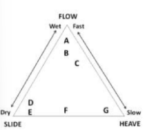
This question was previously asked in
CSIR NET 2019 Earth Science Question Paper (15-Dec-2019)
The correct answer is
C is solifluction and F is talus creep
To solve this question, we need to identify the type of mass movements indicated by the labels in the given diagram. Mass movements are processes by which soil, sand, regolith, and rock move downslope, typically as a solid, continuous mass, largely under the influence of gravity.
Let's analyze the options provided using the diagram:
- A is earthflow and G is talus creep: An earthflow is a form of flow, which would typically be considered under "Wet" or "Fast". Talus creep refers to the slow movement of sediment or rock, which should be closer to "Heave" (slow). However, G is identified with "Slide" and "Heave", not flow, making this option unlikely.
- C is solifluction and F is talus creep (Correct Answer): Solifluction is a very slow type of flow occurring in cold, polar regions, typically aligning with "Flow" and "Slow". Talus creep is a slow movement of rock debris or sediments, aligning with "Heave" and "Slide" for F. This matches the exact characteristics in the diagram, making this the correct choice.
- D is landslide and B is mudflow: Landslides imply a rapid movement along a discrete surface, usually associated with "Slide". Mudflow falls under "Flow" and is fast and wet, not matching with B. This option does not align well with the given diagram structure.
- E is rock slide and B is creep: A rock slide is a type of rapid slide, which typically aligns with "Slide". Creep is a very slow process, aligning with "Heave", not flow, making this option incorrect for B.
Based on this reasoning, the correct answer is C is solifluction and F is talus creep.
Was this answer helpful?
Similar Questions
- On transport-limited slopes, the rate of
- Stream competence denotes the transport of sediment of
- Which one of the following geomorphological features is a proven crater created by meteorite impact?
- A depositional feature attached at one end to the mainland and backed by a lagoon or marshland is known as
- A relative sea level rise CANNOT result from the
Forming agent, landform and processes are given in columns A, B and C, respectively
A B C P Glacial Moraine Erosional Q Peri-glacial Horn Frost Heave R Glacio-fluvial Pingo Depositional S Glacial Kame Erosional
Identify the correct match
Important Questions from Geomorphology
- Match the following
A Evaporites O Ventifacts B Deflation P Desert varnish C Sandblasting Q Playa D Weathering R Desert pavement E Streamlined hills S Yardangs - Match List-I with List –II and select the correct answer using the codes given below the lists
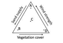
List-I List-II A Bajada P Aeolian B Dreikanter Q Desert C Karn R Glacial D Dolines S Karst Indentify the sand dune forms that are likely to develop
- If L=sediment load, $\text{D}_{50}$=median sediment size, $\bar{Q}$=mean discharge and S=slope then which one of the following relationships is correct?
- Unpaired non-cyclic river terraces are NOT associated with
Need Expert Advice?
Test Series

Teaching
CSIR NET 2025 Mathematical Science Mock Test Series
47 Tests
523 Attempts
3.8(12)
English
More Questions from CSIR NET


