Identifying Depositional Features: Spit
The question describes a specific type of depositional landform. Let's analyze the characteristics provided:
- It's a depositional feature, meaning it's formed by the accumulation of sediments.
- It's attached at one end to the mainland.
- It is backed by a lagoon or marshland, indicating the feature partially encloses or shelters an area behind it.
Based on these criteria, the feature is a Spit.
Understanding Coastal Landforms
A spit is a depositional landform formed by longshore drift. It typically occurs when a headland or a change in the coastline causes the current to slow down, depositing sediment. One end remains connected to the mainland, while the other end extends into the sea or across an estuary, often curving landward at its tip. The sheltered area behind the spit frequently develops into a lagoon or marshland.
Why Other Options Are Incorrect
Let's examine why the other options do not fit the description:
- Beach ridge: This is a ridge parallel to the coast, formed by wave action. It doesn't necessarily connect to the mainland at only one end or form a lagoon behind it.
- Beach cusp: These are regularly spaced, crescent-shaped formations along the beach face, related to wave erosion and swash dynamics, not large-scale depositional features enclosing lagoons.
- Tidal flat: This is an area of sediment exposed at low tide and submerged at high tide. It's a broad, flat area, not a linear feature attached to the mainland and forming a lagoon.
Therefore, the depositional feature described is a spit.
Similar Questions
Study the diagram and identify the type of mass movement from the choice given below:
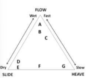
- On transport-limited slopes, the rate of
- Stream competence denotes the transport of sediment of
- Which one of the following geomorphological features is a proven crater created by meteorite impact?
- A relative sea level rise CANNOT result from the
Forming agent, landform and processes are given in columns A, B and C, respectively
A B C P Glacial Moraine Erosional Q Peri-glacial Horn Frost Heave R Glacio-fluvial Pingo Depositional S Glacial Kame Erosional
Identify the correct match
Important Questions from Geomorphology
- Match the following
A Evaporites O Ventifacts B Deflation P Desert varnish C Sandblasting Q Playa D Weathering R Desert pavement E Streamlined hills S Yardangs - Match List-I with List –II and select the correct answer using the codes given below the lists
List-I List-II A Bajada P Aeolian B Dreikanter Q Desert C Karn R Glacial D Dolines S Karst Indentify the sand dune forms that are likely to develop
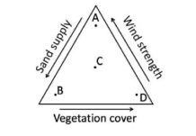
- If L=sediment load, $\text{D}_{50}$=median sediment size, $\bar{Q}$=mean discharge and S=slope then which one of the following relationships is correct?
- Unpaired non-cyclic river terraces are NOT associated with