
Match List-I with List-II and select the correct answer using the code given below the Lists : List-I (Mountain Range) List-II (Location in Map) A. Satpura B. Vindhya C. Aravalli D. Mahadeo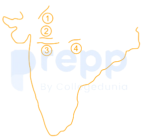
A-3, B-2, C-1, D-4
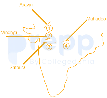
- Satpura mountain range is the part of Deccan plateau. The hills stretch for some 900 km across the widest part of peninsular India, through Maharashtra and Madhya Pradesh states.
- Vindhya mountain range from Gujarat state on the west, it extends about 1,086 km across MadhyaPradesh state to touch Ganga River valley near Varanasi, UttarPradesh.
- Aravalli mountain range runs north-east for 560 km and mostly in Rajasthan
- Mahadeo mountain range is in the northern part of the Satpura range, in the southern Madhya Pradesh state.
Note:
India has seven highest mountain ranges:
- The Himalaya Range
- Karakoram and Pir Panjal Range
- Eastern Mountain range or The Purvanchal Range
- The Satpura and Vindhaya Range
- The Aravalli Range
- The Western Ghats
- The Eastern Ghats
Similar Questions
Which one of the following Indian States has no international boundary?
Sea of Azov is connected to _______.
Which of the following pairs is / are correctly matched?
Plateau
Continent
1.
Abyssinian
Africa
2.
Patagonian
Australia
3.
Anatolian
Asia
4.
Iberian
North America
Select the correct answer using the code given below:
Which one of the following mountains separates Black Sea and Caspian Sea?
Which one of the following pairs of lakes are connected by Soo Canal?
Match List-I and List-II and select the correct answer using the code given below the Lists:
List-I (Strait)
List-II (Water Body)
A.
Strait of Hormuz
1.
Java Sea
B.
Strait of Bab-el-Mandeb
2.
Andaman Sea
C.
Strait of Malacca
3.
Red Sea
D.
Strait of Sunda
4.
Gulf of Persia
Which one of the following fishing banks are located off the coast of the United Kingdom?
The South China Sea Dispute involves which of the following countries?
1. China
2. Vietnam
3. Malaysia
4. Indonesia
Select the correct answer using the code given below.
D had recently visited Khardung La, Nubra Valley and several Buddhist monasteries. Which one of the following States / UT had she visited ?
Which one among the following is considered the deepest point of the oceans?
Important Questions from Mapping
Lake Titcaca, the highest lake in the world, is situated between _______.
The three components of maps are:
______ plains are formed due to the weathering of soluble rocks such as limestone and dolomite.
Which one of the following denotes the lines joining equal amount of travel time?
Which of the following is the highest peak in the Eastern Ghats?



