
Which one of the following fishing banks are located off the coast of the United Kingdom?
Dogger Bank
Fishing Banks Off the United Kingdom Coast
This explanation identifies the specific fishing bank situated off the coast of the United Kingdom from the given options. Understanding the geographical locations of major fishing banks is crucial in marine geography and fisheries management.
Locating Fishing Banks Relative to the UK
Let's examine the locations of the fishing banks mentioned in the options:
- Dogger Bank: This is a large, relatively shallow area of the North Sea. It is located east of the Northern UK mainland and west of Denmark. A significant portion of the Dogger Bank lies within the UK's Exclusive Economic Zone (EEZ), making it a key fishing ground associated with the United Kingdom.
- Grand Banks: This is a group of underwater features located off the coast of Newfoundland and Labrador in Canada. It is situated in the Atlantic Ocean and is geographically distant from the United Kingdom.
- Great Fisher Bank: Also located in the North Sea, the Great Fisher Bank lies to the east of the Dogger Bank. While parts may fall within or near UK waters, the Dogger Bank is more prominently and centrally located off the UK coast among these choices.
- Reed Bank: This feature is located in the South China Sea, associated with the Spratly Islands. It is geographically very far from the United Kingdom.
Identifying the Correct Fishing Bank
Based on the geographical locations:
- The Grand Banks are in North America.
- The Reed Bank is in the South China Sea.
- The Great Fisher Bank is in the North Sea, east of the Dogger Bank.
- The Dogger Bank is a major submarine plateau situated in the southern North Sea, directly off the coast of the United Kingdom.
Therefore, the Dogger Bank is the fishing bank located off the coast of the United Kingdom.
Similar Questions
Which one of the following Indian States has no international boundary?
Sea of Azov is connected to _______.
Which of the following pairs is / are correctly matched?
Plateau
Continent
1.
Abyssinian
Africa
2.
Patagonian
Australia
3.
Anatolian
Asia
4.
Iberian
North America
Select the correct answer using the code given below:
Which one of the following mountains separates Black Sea and Caspian Sea?
Match List-I with List-II and select the correct answer using the code given below the Lists :
List-I (Mountain Range)
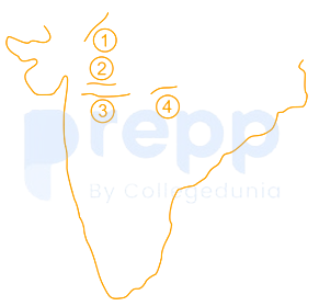
List-II (Location in Map)
A. Satpura
B. Vindhya
C. Aravalli
D. Mahadeo
Match List— I with List— II and select the correct answer using the code given below the Lists:
List-I (States of NE India)
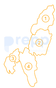
List-II (Location in Map)
A. Tripura
B. Mizoram
C. Nagaland
D. Manipur
Which one of the following pairs of lakes are connected by Soo Canal?
Match List-I and List-II and select the correct answer using the code given below the Lists:
List-I (Strait)
List-II (Water Body)
A.
Strait of Hormuz
1.
Java Sea
B.
Strait of Bab-el-Mandeb
2.
Andaman Sea
C.
Strait of Malacca
3.
Red Sea
D.
Strait of Sunda
4.
Gulf of Persia
The South China Sea Dispute involves which of the following countries?
1. China
2. Vietnam
3. Malaysia
4. Indonesia
Select the correct answer using the code given below.
D had recently visited Khardung La, Nubra Valley and several Buddhist monasteries. Which one of the following States / UT had she visited ?
Important Questions from Mapping
Lake Titcaca, the highest lake in the world, is situated between _______.
The three components of maps are:
______ plains are formed due to the weathering of soluble rocks such as limestone and dolomite.
Which one of the following denotes the lines joining equal amount of travel time?
Which of the following is the highest peak in the Eastern Ghats?



