
The Eight Degree Channel separates which of the following?
Lakshadweep from Maldives
Understanding the Eight Degree Channel Separation
The question asks about the geographical separation created by the Eight Degree Channel. Identifying significant channels and straits is crucial for understanding the geography of the region around India and its island territories.
What is the Eight Degree Channel?
The Eight Degree Channel is a narrow body of water that lies between the island of Minicoy, which is part of the Lakshadweep archipelago of India, and the northernmost islands of the Maldives. It is named the "Eight Degree Channel" because it is located approximately along the 8-degree line of latitude North (\({8^\circ}\text{N}\)).
Channels are important geographical features that often mark boundaries or facilitate navigation. Understanding which landmasses are separated by these channels helps in grasping regional geography.
Analysing the Options
Let's examine each option provided to determine which one correctly describes the separation caused by the Eight Degree Channel:
- Option 1: India from Sri Lanka
This option is incorrect. India is separated from Sri Lanka by the Palk Strait, a shallow body of water, and the Gulf of Mannar.
- Option 2: Lakshadweep from Maldives
This option states that the Eight Degree Channel separates Lakshadweep from Maldives. Specifically, it separates Minicoy Island (the southernmost island of Lakshadweep) from the main group of Maldives islands to its south. This aligns with our understanding of the Eight Degree Channel's location and significance.
- Option 3: Andaman from Nicobar Islands
This option is incorrect. The Andaman Islands and the Nicobar Islands, both part of India's Andaman and Nicobar Islands Union Territory, are separated by the Ten Degree Channel (\({10^\circ}\text{N}\) latitude).
- Option 4: Indira Point from Indonesia
This option is incorrect. Indira Point is the southernmost tip of Great Nicobar Island (part of the Nicobar Islands). The channel separating Great Nicobar Island (and thus Indira Point) from Sumatra in Indonesia is known as the Great Channel (or Six Degree Channel, located roughly along the \({6^\circ}\text{N}\) latitude).
Based on the analysis, the Eight Degree Channel separates Lakshadweep from the Maldives.
Comparison of Important Channels
Here is a summary table of the major channels discussed:
| Channel Name | Latitude Approx. | Separates |
|---|---|---|
| Eight Degree Channel | \({8^\circ}\text{N}\) | Lakshadweep (Minicoy) from Maldives |
| Nine Degree Channel | \({9^\circ}\text{N}\) | Minicoy Island from the main Lakshadweep archipelago |
| Ten Degree Channel | \({10^\circ}\text{N}\) | Andaman Islands from Nicobar Islands |
| Great Channel (Six Degree Channel) | \({6^\circ}\text{N}\) | Great Nicobar Island (India) from Sumatra (Indonesia) |
| Palk Strait | India from Sri Lanka |
Conclusion on Eight Degree Channel Separation
The Eight Degree Channel serves as a significant maritime boundary. It precisely separates Minicoy Island, which is the southernmost island of the Lakshadweep group belonging to India, from the islands that constitute the northern part of the Maldives. This geographical feature is important for navigation and understanding the political boundaries in the Indian Ocean.
Therefore, the correct answer is that the Eight Degree Channel separates Lakshadweep from Maldives.
Revision Table: Key Channels and Separations
| Channel | Separates | Location Context |
|---|---|---|
| Eight Degree Channel | Lakshadweep & Maldives | Between Minicoy (Lakshadweep) and northern Maldives |
| Nine Degree Channel | Lakshadweep (main group) & Minicoy | North of Minicoy, within the Lakshadweep group |
| Ten Degree Channel | Andaman & Nicobar Islands | Between Little Andaman and Car Nicobar |
| Great Channel | India (Great Nicobar) & Indonesia (Sumatra) | South of Great Nicobar |
| Palk Strait | India & Sri Lanka | Between Tamil Nadu coast and Jaffna District of Sri Lanka |
Additional Information: Geographical Channels and Straits
Channels and straits are crucial geographical features, often serving as vital shipping routes or defining political boundaries. They are narrow passages of water connecting two larger bodies of water. Here are some related concepts:
- Strait: A naturally formed narrow passage of water that connects two large bodies of water. Examples include the Strait of Gibraltar and the Palk Strait.
- Channel: Can refer to a strait, or it can be a wider waterway than a strait, or a deeper part of a waterway. In the context of islands, channels often separate island groups or individual islands.
- Maritime Boundaries: Channels and straits frequently form international or internal maritime boundaries between countries or administrative regions.
- Navigational Importance: Many channels are critical for international shipping and trade, making them strategically important.
Understanding these geographical features helps in studying physical geography and political boundaries.
Similar Questions
Which one of the following Indian States has no international boundary?
Sea of Azov is connected to _______.
Which of the following pairs is / are correctly matched?
Plateau
Continent
1.
Abyssinian
Africa
2.
Patagonian
Australia
3.
Anatolian
Asia
4.
Iberian
North America
Select the correct answer using the code given below:
Which one of the following mountains separates Black Sea and Caspian Sea?
Match List-I with List-II and select the correct answer using the code given below the Lists :
List-I (Mountain Range)
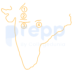
List-II (Location in Map)
A. Satpura
B. Vindhya
C. Aravalli
D. Mahadeo
Match List— I with List— II and select the correct answer using the code given below the Lists:
List-I (States of NE India)
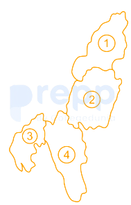
List-II (Location in Map)
A. Tripura
B. Mizoram
C. Nagaland
D. Manipur
Which one of the following pairs of lakes are connected by Soo Canal?
Match List-I and List-II and select the correct answer using the code given below the Lists:
List-I (Strait)
List-II (Water Body)
A.
Strait of Hormuz
1.
Java Sea
B.
Strait of Bab-el-Mandeb
2.
Andaman Sea
C.
Strait of Malacca
3.
Red Sea
D.
Strait of Sunda
4.
Gulf of Persia
Which one of the following fishing banks are located off the coast of the United Kingdom?
Mount Thullier (642 m) is an important mountain peak in the Andaman and Nicobar Islands. It is located in:
Important Questions from Mapping
Considering its colossal scale, which volcano holds the record for being the largest by both mass and volume in the entire solar system, a prominent shield formation located on Mars and characterized by its extensive caldera system?
Longest chain of mountain is ___________.
Lake Titcaca, the highest lake in the world, is situated between _______.
The three components of maps are:
______ plains are formed due to the weathering of soluble rocks such as limestone and dolomite.



