Eastern Coastal Plains River Delta Formation
This solution details how rivers form deltas and identifies the specific river from the options provided that creates a delta along India's Eastern Coastal Plains.
Understanding River Deltas and Coastal Plains
A delta is a landform shaped by the deposition of sediment carried by a river as it flows into a slower-moving or stationary body of water, such as a sea, ocean, or lake. The word "delta" comes from the Greek letter delta (Δ), reflecting the typically triangular shape of these features.
The Eastern Coastal Plains of India are a significant geographical region stretching along the eastern coast, adjacent to the Bay of Bengal. Rivers that flow eastward from the peninsula generally form extensive deltas in this region due to the gentle slope and the deposition of sediments carried into the relatively calmer waters of the Bay of Bengal.
Analysis of Rivers and Delta Formation
Let's analyze the geographical path and characteristics of each river listed:
- Narmada River: The Narmada flows westward, traversing through a rift valley. It empties into the Arabian Sea. Rivers flowing west on the Indian peninsula typically form estuaries rather than deltas at their mouths because they flow over a steeper gradient and drain into the Arabian Sea, which has a narrower continental shelf.
- Tapi River: The Tapi River, like the Narmada, also flows westward and drains into the Arabian Sea. It similarly forms an estuary and does not contribute to delta formation on the Eastern Coastal Plains.
- Mahi River: The Mahi River follows a complex westward path before emptying into the Arabian Sea. It does not form a delta on the eastern coast.
- Godavari River: The Godavari River originates in the Western Ghats and flows east across the Deccan Plateau. After a long course, it empties into the Bay of Bengal. Along its mouth on the Eastern Coastal Plains, the Godavari deposits a substantial amount of sediment, forming a large, well-developed, and fertile delta. This delta is a prominent feature of the region.
Conclusion on Delta Formation
Comparing the drainage patterns and coastal destinations of these rivers, it is clear that the Godavari River is the one responsible for forming a delta on the Eastern Coastal Plains.
Similar Questions
- Consider the following statements regarding the evolution of India's major drainage systems:
1.The ancient Indo-Brahma river is believed to have split into three major drainage systems over time.
2.The Ganga and its Himalayan tributaries represent the central drainage system.
3.The western drainage system consists of the Brahmaputra and its tributaries.
Which of the above statements is/are correct? In which of the following protected areas is the historic "Taruba" lake located, renowned for being the oldest and largest national park in the state of Maharashtra?
Read the given below statements carefully and choose the correct option:
Assertion (A): The Chambal River is known for its badland topography called the Chambal ravines.
Reason (R): The Chambal flows through a deep gorge and eroded terrain before joining the Yamuna.- The Alaknanda River originates from which of the following?
- Which of these rivers does not originate in the Peninsular Plateau of India?
Important Questions from Drainage System of India
With reference to river Teesta, consider the following statements:
1. The source of river Teesta is the same as that of Brahmaputra but it flows through Sikkim.
2. River Rangeet originates in Sikkim and it is a tributary of river Teesta.
3. River Teesta falls into Bay of Bengal at the border of India and Bangladesh.
Which of the statements given above is/are correct?
Consider the following rivers:
(1) Barak
(2) Lohit
(3) Subansiri
Which of the above flows/flow through Arunachal Pradesh?
Consider the following pairs:
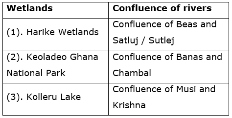
Which of the above pairs is/are correctly matched?
- Which river system is known for forming gorges in the Himalayan region?
- Which of the following rivers originates in the Western Ghats?