
Which of the following errors can be eliminated by reciprocal measurements in differential leveling? I. Error due to earth curvature II. Error due to atmospheric refraction
Both I and II
Reciprocal Measurements in Differential Leveling
Differential leveling is a surveying method used to determine the difference in elevation between two points. While highly accurate, it is susceptible to various errors. Two significant natural errors that can affect the accuracy of leveling are the error due to earth curvature and the error due to atmospheric refraction. Fortunately, a technique called reciprocal leveling or reciprocal measurements can effectively eliminate these errors.
Understanding Leveling Errors
- Earth Curvature Error: The Earth's surface is curved, not flat. When a level instrument is set up, its line of sight is horizontal (tangent to the level surface at the instrument). However, as the line of sight extends, it diverges from the curved Earth's surface. This makes a staff reading appear higher than it actually is relative to a truly level line connecting the two points. The formula for curvature error is $C = 0.0785 \times D^2$, where $D$ is the distance in kilometers and $C$ is the error in meters. This error is always positive (makes readings seem lower than they should be, meaning the actual elevation difference is underestimated if not corrected).
- Atmospheric Refraction Error: Light rays bend as they pass through the Earth's atmosphere, especially when light travels through air layers of different densities (e.g., due to temperature variations). This bending, known as refraction, causes the line of sight from the leveling instrument to bend downwards towards the Earth's surface. As a result, the staff reading appears lower than it actually is. Refraction error typically acts in the opposite direction to curvature error, often being about one-seventh of the curvature error.
Both earth curvature and atmospheric refraction errors are systematic and tend to accumulate over long distances, affecting the accuracy of elevation measurements.
Eliminating Errors with Reciprocal Measurements
Reciprocal measurements, or reciprocal leveling, is a technique specifically designed to counteract and eliminate the effects of systematic errors like earth curvature and atmospheric refraction. This method is particularly useful when leveling across obstacles such as wide rivers, valleys, or gorges where it's impossible to set up the leveling instrument midway between the two points.
The principle of reciprocal leveling involves:
- First Setup: The leveling instrument is set up very close to the first point (say, point A), and readings are taken on staffs held at both point A and point B (the distant point across the obstacle).
- Second Setup: The instrument is then moved and set up very close to the second point (point B), and readings are again taken on staffs held at both point A and point B.
How this eliminates errors:
- Earth Curvature: The curvature error depends on the distance from the instrument to the staff. When observations are made from both ends of the line (A to B and B to A), the curvature effect on the observed elevation difference will be equal in magnitude but opposite in sign relative to the true difference. By averaging the two observed differences in elevation, the curvature error cancels out completely.
- Atmospheric Refraction: Similarly, the atmospheric conditions (and thus the refraction effect) are assumed to be consistent along the line of sight during the short period of reciprocal observations. When readings are taken from both ends, the bending of the light ray due to refraction will have an equal and opposite effect on the observed elevation difference in each setup. Averaging these two sets of readings effectively cancels out the refraction error.
Therefore, by performing reciprocal measurements, both the error due to earth curvature (I) and the error due to atmospheric refraction (II) can be effectively eliminated, leading to a much more accurate determination of the relative elevation between the two points.
Important Questions from Levelling
For the traverse given below, the benchmark is at ground point L. The Reduced Level (RL) of L is 150.000 m. The direction of the traverse is from L to N. The readings on levelling staff using the same levelling instrument kept at Stations S1 and S2 during the traversing are shown in the figure.
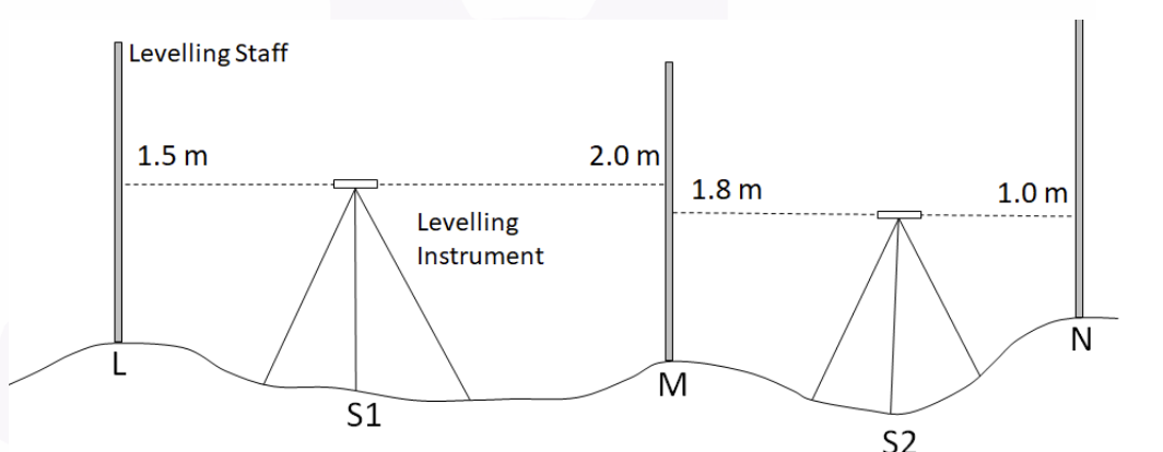
Column 1 Column 2 (P) 3.300 m (I) Sum of Back Sights (Q) 2.500 m (II) Sum of Fore Sights (R) 150.300 m (III) RL of Point N (S) 3.000 m (T) 150.500 m Matching the information given under Column 1 and Column 2, which one of the following options is CORRECT?
Which of the following is the CORRECT ratio of refraction correction to curvature correction?
The following sights are taken on a “turning point”
If the bench mark is 560.50 m. and height of instrument is 561.365 m. then, what will be back sight ?
________ is a relatively permanent point of reference whose elevation w.r.t. some assumed datum is known.


