
The following sights are taken on a “turning point”
foresight and back-sight
Turning Point in Surveying Explained
In the field of surveying, specifically during leveling operations, a turning point is a crucial location. It serves as an intermediate station where the leveling staff is held so that readings can be taken from two different instrument setups. The primary purpose of a turning point is to connect the elevation measurements from one instrument position to the next, ensuring the continuity of the leveling process.
What is a Turning Point?
A turning point, often referred to as a change point, is necessary when the distance to the next point is too far, or an obstruction prevents a direct line of sight from the current instrument position. When the leveling instrument needs to be moved to a new setup location, a common reference point is required. This common point is the turning point, which helps in transferring the elevation from the previous setup to the new setup.
Sights Taken at a Turning Point
At a turning point, two distinct types of staff readings are always taken:
- Foresight (FS): This is the last staff reading taken from the previous instrument setup. It is a reading taken looking forward along the direction of the survey, typically towards a point whose reduced level (RL) is to be determined or is an intermediate point like a turning point. The foresight reading from the turning point is subtracted from the Height of Instrument (HI) of the old setup to determine the Reduced Level (RL) of the turning point.
- Back-sight (BS): This is the first staff reading taken from the new instrument setup. It is a reading taken looking backward from the new instrument position towards a point whose reduced level is already known or has just been determined (in this case, the turning point). The back-sight reading from the turning point is added to its Reduced Level (RL) to calculate the new Height of Instrument (HI) for the current setup.
The sequence is always: instrument setup 1 → back-sight on a known point (or start point) → intermediate sights → foresight on the turning point. Then, instrument is shifted to setup 2 → back-sight on the turning point → intermediate sights → foresight on the next point or next turning point.
Importance of Both Foresight and Back-sight
The act of taking both a foresight and a back-sight on the same turning point is fundamental to accurate leveling. The foresight from the old instrument position establishes the elevation of the turning point relative to the previous setup. Subsequently, the back-sight from the new instrument position uses this established elevation of the turning point to determine the new height of instrument. This ensures a seamless and accurate transfer of elevations across multiple instrument setups, maintaining the integrity of the entire level line. Without both readings, the leveling chain would be broken, leading to errors in elevation calculations for subsequent points.
Important Questions from Levelling
For the traverse given below, the benchmark is at ground point L. The Reduced Level (RL) of L is 150.000 m. The direction of the traverse is from L to N. The readings on levelling staff using the same levelling instrument kept at Stations S1 and S2 during the traversing are shown in the figure.
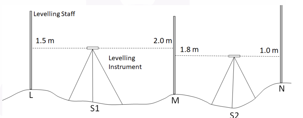
Column 1 Column 2 (P) 3.300 m (I) Sum of Back Sights (Q) 2.500 m (II) Sum of Fore Sights (R) 150.300 m (III) RL of Point N (S) 3.000 m (T) 150.500 m Matching the information given under Column 1 and Column 2, which one of the following options is CORRECT?
Which of the following errors can be eliminated by reciprocal measurements in differential leveling?
I. Error due to earth curvature
II. Error due to atmospheric refraction
Which of the following is the CORRECT ratio of refraction correction to curvature correction?
If the bench mark is 560.50 m. and height of instrument is 561.365 m. then, what will be back sight ?
________ is a relatively permanent point of reference whose elevation w.r.t. some assumed datum is known.


