
________ is a relatively permanent point of reference whose elevation w.r.t. some assumed datum is known.
Bench Mark
Bench Mark: A Core Concept in Surveying
In the field of surveying, accurately determining and recording elevations is crucial for various engineering and construction projects. To achieve this, surveyors rely on established reference points. The question asks to identify a "relatively permanent point of reference whose elevation w.r.t. some assumed datum is known."
Understanding Key Surveying Terms
Let's break down the options provided to understand which one best fits the description:
- Bench Mark: A Bench Mark is a precisely defined and relatively permanent point of known elevation. This elevation is determined with respect to a specific vertical datum, such as Mean Sea Level. Bench Marks are typically marked with durable objects like metal disks embedded in concrete, rock, or buildings, ensuring their stability and long-term use. They serve as fundamental reference points for all leveling operations in an area.
- Mean Sea Level: Mean Sea Level (MSL) is a widely used vertical datum. It represents the average height of the ocean's surface over a long period, typically 19 years, to account for tidal variations. While MSL serves as the reference plane for elevations, it is a datum itself, not a specific physical point of reference whose elevation *with respect to* a datum is known (as it *is* the datum).
- Ground Level: Ground Level refers to the elevation of the natural ground surface at a particular location. This elevation is highly variable and not a fixed, permanent reference point with a pre-determined, precise elevation for surveying purposes.
- Level Line: A Level Line is an imaginary line on a level surface. A level surface is one that is everywhere perpendicular to the direction of gravity (i.e., perpendicular to the plumb line). While related to elevation, a level line is a conceptual line or surface, not a specific physical point of reference.
Bench Mark as the Correct Reference Point
Based on the definitions, a Bench Mark perfectly matches the description in the question:
- It is a relatively permanent point of reference, meaning it's fixed and durable.
- Its elevation is known, having been precisely measured.
- This known elevation is always stated with respect to some assumed datum, commonly Mean Sea Level.
Therefore, a Bench Mark serves as the fundamental control point for establishing elevations for various engineering and construction projects, ensuring consistency and accuracy in height measurements across different locations and times.
Important Questions from Levelling
For the traverse given below, the benchmark is at ground point L. The Reduced Level (RL) of L is 150.000 m. The direction of the traverse is from L to N. The readings on levelling staff using the same levelling instrument kept at Stations S1 and S2 during the traversing are shown in the figure.
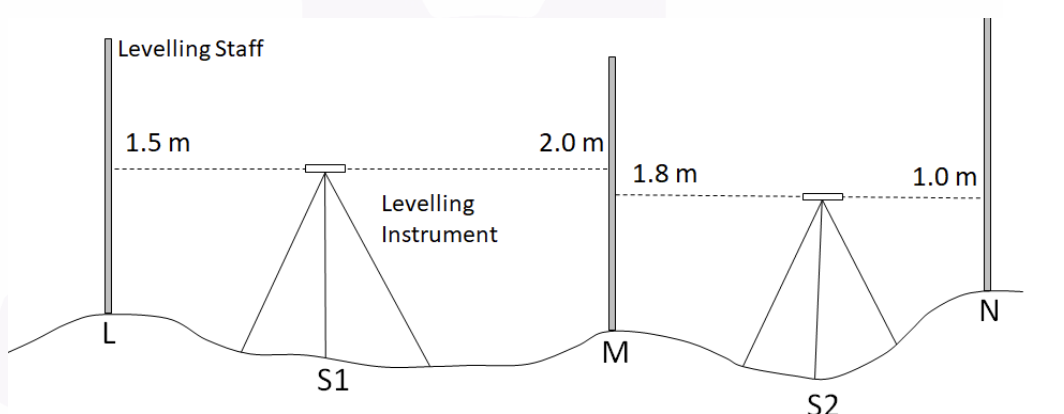
Column 1 Column 2 (P) 3.300 m (I) Sum of Back Sights (Q) 2.500 m (II) Sum of Fore Sights (R) 150.300 m (III) RL of Point N (S) 3.000 m (T) 150.500 m Matching the information given under Column 1 and Column 2, which one of the following options is CORRECT?
Which of the following errors can be eliminated by reciprocal measurements in differential leveling?
I. Error due to earth curvature
II. Error due to atmospheric refraction
Which of the following is the CORRECT ratio of refraction correction to curvature correction?
The following sights are taken on a “turning point”
If the bench mark is 560.50 m. and height of instrument is 561.365 m. then, what will be back sight ?


