
Statement A: High values of hypsometric integral indicate a relatively large proportion of land at high elevation within the basin.
Statement B: Basins in which stream channels have incised deep valleys, leaving extensive areas of relatively high elevation, have low hypsometric integrals.
Based on the above statements, choose the correct option.
Hypsometric Integral Concept
The hypsometric integral is a geomorphological concept used to describe the shape of a drainage basin's hypsometric curve. Essentially, it represents the amount of potential energy stored within the basin based on its topography. It's calculated as the ratio of the area above the hypsometric curve to the total area of the basin.
A hypsometric curve plots the cumulative area of a basin from its summit down to its outlet against the relative height. The hypsometric integral helps us understand the stage of landscape evolution:
- High hypsometric integral values (close to 1.0): Indicate that a large proportion of the basin's area is concentrated at higher elevations. This is typical of youthful or mountainside basins that haven't undergone extensive erosion.
- Low hypsometric integral values (close to 0.0): Suggest that most of the basin's area is found at lower elevations. This is characteristic of mature or old-age basins that have been significantly eroded, with lower relief.
Statement A: High Integral Indicates High Elevation Areas
Statement A posits that high values of the hypsometric integral signify a relatively large proportion of land at high elevation within the basin. Based on the definition and interpretation of the hypsometric integral, this statement is correct. When the integral is high, it means the hypsometric curve is positioned higher on the graph, signifying that a significant portion of the basin's total surface area is found at higher altitudes. This indicates less overall erosion and a landscape dominated by higher terrain.
Statement B: Valley Incision and Integral Value
Statement B suggests that basins with deeply incised stream channels, which leave extensive areas of relatively high elevation, possess low hypsometric integrals. This statement is incorrect.
Let's break down why:
- Deep Valleys: The incision of deep valleys by streams is a process of erosion that lowers the land surface.
- Extensive Areas of High Elevation Remaining: If, after significant valley incision, there are *still* extensive areas of relatively high elevation left within the basin, it implies that these higher regions constitute a large fraction of the basin's total area.
- Impact on Integral: A landscape characterized by deep valleys cutting through what remains a significant amount of higher ground would have a hypsometric curve that stays elevated for a considerable portion of the relative height range. This configuration leads to a high hypsometric integral, not a low one. Low integrals are associated with landscapes where most of the area is at low elevations, meaning the basin has been extensively reduced in height overall.
Therefore, basins with deep valleys but substantial remaining high-elevation areas are expected to have high, not low, hypsometric integrals.
Conclusion
Evaluating both statements based on the principles of geomorphology and the hypsometric integral reveals that Statement A accurately describes the relationship between a high integral and high elevation areas, while Statement B incorrectly associates deep valley incision with low integral values.
Important Questions from Geomorphology
- Match the following
A Evaporites O Ventifacts B Deflation P Desert varnish C Sandblasting Q Playa D Weathering R Desert pavement E Streamlined hills S Yardangs - Match List-I with List –II and select the correct answer using the codes given below the lists
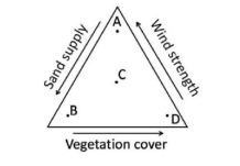
List-I List-II A Bajada P Aeolian B Dreikanter Q Desert C Karn R Glacial D Dolines S Karst Indentify the sand dune forms that are likely to develop
- If L=sediment load, $\text{D}_{50}$=median sediment size, $\bar{Q}$=mean discharge and S=slope then which one of the following relationships is correct?
- Unpaired non-cyclic river terraces are NOT associated with


