NavIC: ISRO's 100th Launch Powers India's Precision Navigation System
Why in news?
- ISRO's 100th Launch: NVS-02 Satellite Powers Up India’s NavIC For Precision Navigation.
Introduction to NavIC
- NavIC (Navigation with Indian Constellation) is India’s indigenous satellite navigation system, developed by the Indian Space Research Organisation (ISRO).
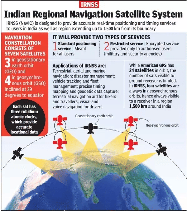
- It serves as the Indian Regional Navigation Satellite System (IRNSS), providing positioning and timing services across India and surrounding regions, extending up to 1,500 km from its borders.
- NavIC is designed to reduce India’s dependence on foreign navigation systems like GPS, GLONASS, and Galileo.
Why NavIC Was Developed
- NavIC was initiated to ensure India’s strategic independence and national security, especially after India faced challenges during the Kargil War (1999) when GPS services were denied.
- By establishing its own satellite navigation system, India guarantees secure and uninterrupted navigation services for both military and civilian use, even during critical times.
NavIC System Architecture
- Satellites: NavIC comprises a constellation of seven satellites, three in geostationary orbit (GEO) and four in inclined geostationary orbit (GSO).
- Ground Segment: It features control centers, monitoring stations, and facilities for time synchronization.
- Frequency Bands: NavIC uses L5 and S bands, and with the launch of second-generation satellites, L1 frequency will be added, enhancing its compatibility with global systems like GPS.
NavIC Accuracy and Coverage
- Accuracy: NavIC offers positioning accuracy of better than 20 meters within India’s primary coverage area. It can reach up to 5 meters with restricted services.
- Coverage Area: The system’s primary coverage spans India and an area up to 1,500 km from its borders. The extended coverage stretches from 30° South to 50° North latitude and from 30° East to 130° East longitude.
Two Types of NavIC Services
- Standard Positioning Service (SPS): Available to all users, offering general positioning services.
- Restricted Service (RS): An encrypted service available only to authorized users, typically for military and strategic applications.
Operational Advantages of NavIC
- Self-reliance: India has complete control over the system, ensuring uninterrupted and secure navigation services.
- Enhanced Accuracy: NavIC offers superior accuracy compared to GPS, with signals that can provide up to 5 meters of precision.
- Constant Coverage: Geostationary satellites maintain fixed positions, ensuring continuous monitoring of the same region.
- Effective Signal Reception: NavIC’s signal can penetrate dense forests, mountainous terrains, and urban areas, improving accessibility in challenging environments.
- Global Interoperability: NavIC works seamlessly with global navigation systems such as GPS, GLONASS, Galileo, and BeiDou, ensuring compatibility and enhancing navigation accuracy.
Key Applications of NavIC
- Military: Provides secure and precise navigation for defense operations.
- Civil Aviation: Enhances air traffic management, navigation, and safety procedures.
- Maritime Navigation: Improves positioning for commercial shipping and fishing vessels, aiding coastal surveillance.
- Agriculture: Supports precision farming, helping with field mapping, crop monitoring, and resource management.
- Transportation & Fleet Management: Real-time navigation for vehicles, improving logistics and reducing costs.
- Disaster Management: Assists in coordinating rescue operations and monitoring disaster-affected areas.
Future Developments
- Second-Generation Satellites: The new generation of NavIC satellites will include atomic clocks, improving accuracy and reliability.
- L1 Frequency: The addition of L1 frequency will improve NavIC’s compatibility with consumer devices like smartphones, wearables, and personal trackers.
- Expansion into Mobile Devices: Increasing integration into mobile phones and other public systems is expected, providing wider access to NavIC services.
Strategic Significance of NavIC
- Self-Reliance: NavIC reinforces India’s position as a self-sufficient nation in satellite navigation technology.
- Diplomatic Relations: NavIC’s regional coverage opens the door for data-sharing with neighboring countries, strengthening diplomatic ties and fostering cooperation across South Asia.
Conclusion
- NavIC is a game-changer for India, offering enhanced security, reliability, and accuracy in navigation services. As it continues to evolve, it will play a crucial role in India’s defense, civilian infrastructure, and global standing in satellite navigation.
Download the PREPP App and attempt FREE IAS Exam Mock Tests and get complete study material!
*The article might have information for the previous academic years, please refer the official website of the exam.
How likely are you to recommend Prepp.in to a friend or a colleague?
Not so likely
Highly likely
UPSC CSE (IAS) 2027 Prelims Mock Test Series
Live Quizzes
Quizzes
Live Tests

• Live
Live Test : UPSC CSE Prelims CSAT (Paper-II) (Oct 08 - 11)
120 Minutes
80 Questions
200 Marks
English, Hindi
MEDIUM
Test will end in 05:31:06
Full Tests
Full Test - 04: UPSC CSE Prelims CSAT (Paper-II)
120 Minutes
80 Questions
200 Marks
English, Hindi
MEDIUM
Attempted by 19 aspirants in 12 hours
Full Test - 03: UPSC CSE Prelims CSAT (Paper-II)
120 Minutes
80 Questions
200 Marks
English, Hindi
MEDIUM
Attempted by 20 aspirants in 12 hours
Previous Year Papers
UPSC CSE Prelims 2026 GS Paper 1 Question Paper (24-May-2026)
120 Minutes
100 Questions
200 Marks
2,989 Attempted
English, Hindi
MEDIUM
Attempted by 12 aspirants in 12 hours
UPSC CSE Prelims 2026 CSAT Paper 2 Question Paper (24-May-2026)
120 Minutes
80 Questions
200 Marks
3,167 Attempted
English, Hindi
MEDIUM
Attempted by 13 aspirants in 12 hours
Videos

17 February 2025 | The Hindu Must Read Articles | Current Affairs
7,202 Views
•4
•7 months ago

16 February 2026 | The Hindu Must Read Articles | Current Affairs
6,962 Views
•4
•7 months ago

13 February 2026 | The Hindu Must Read Articles | Current Affairs
8,765 Views
•5
•7 months ago

12 February 2026 | The Hindu Must Read Articles | Current Affairs
5,788 Views
•4
•7 months ago






Also Check
IAS Exam Overview
IAS Exam Admit Card
IAS Exam Question Paper 2026
IAS Exam Mains Syllabus
IAS Exam Application Process
IAS Exam Eligibility
IAS Exam Result
IAS Exam Exam Pattern
IAS Exam CSAT Syllabus
IAS Exam Answer Key
IAS Exam Previous Year Paper
IAS Exam Current Affairs
IAS Exam Mains Question Paper
IAS Exam IAS Courses
IAS Exam UPSC Study Notes
IAS Exam Foundation Course 2024
IAS Exam Prelims Question Paper
IAS Exam Exam Center
IAS Exam Foundation Course 2025
IAS Exam Notification 2026
IAS Exam IAS Success Stories
IAS Exam Salary
IAS Exam Cutoff
IAS Exam Mock Tests
IAS Exam News


Comments