Golan Heights - Key Facts
Why in news
Israel's government on December 15 approved a plan to double the population of the annexed Golan Heights.
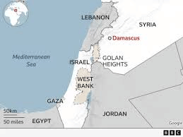
About Golan Heights
- Geography: The Golan Heights is a strategic, hilly region in southwestern Syria, overlooking the upper Jordan River valley and the Sea of Galilee.
- Size and Shape: Extends 71 km from north to south and 43 km from east to west, covering an area of 1,150 sq. km, with a roughly boat-shaped topography.
- Boundaries: It is bordered by the Jordan River and Sea of Galilee to the west, Mount Hermon to the north, Wadi Al-Ruqqād River to the east, and Yarmūk River to the south.
- Historical Context: Previously part of Syria, it came under Israeli occupation during the 1967 Six-Day War. The Syrian population largely fled during this conflict.
- 1973 War and Armistice: Syria's attempt to recapture the region in the 1973 Middle East War was unsuccessful. A ceasefire agreement and UN observer force were established in 1974.
- Israeli Annexation: Israel unilaterally annexed the Golan Heights in December 1981, a move considered illegal under international law but disputed by Israel.
- Settlements: More than 30 Israeli settlements are located in the Golan Heights, home to about 20,000 Israelis. These settlements coexist with 20,000 Druze Arabs who remained after Israeli control.
- Strategic Importance: The Golan Heights holds significant military and geopolitical value, providing a commanding view of Damascus and northern Israel. It is also a crucial source of water for the region, with rainwater feeding into the Jordan River.
Download the PREPP App and attempt FREE IAS Exam Mock Tests and get complete study material!
*The article might have information for the previous academic years, please refer the official website of the exam.
How likely are you to recommend Prepp.in to a friend or a colleague?
Not so likely
Highly likely
UPSC CSE (IAS) 2027 Prelims Mock Test Series
Live Quizzes
Quizzes
Live Tests

• Live
Live Test : UPSC CSE Prelims CSAT (Paper-II) (Oct 08 - 11)
120 Minutes
80 Questions
200 Marks
English, Hindi
MEDIUM
Test will end in 19:01:52
Full Tests
Full Test - 04: UPSC CSE Prelims CSAT (Paper-II)
120 Minutes
80 Questions
200 Marks
English, Hindi
MEDIUM
Attempted by 20 aspirants in 12 hours
Full Test - 03: UPSC CSE Prelims CSAT (Paper-II)
120 Minutes
80 Questions
200 Marks
English, Hindi
MEDIUM
Attempted by 22 aspirants in 12 hours
Previous Year Papers
UPSC CSE Prelims 2026 GS Paper 1 Question Paper (24-May-2026)
120 Minutes
100 Questions
200 Marks
2,976 Attempted
English, Hindi
MEDIUM
Attempted by 13 aspirants in 12 hours
UPSC CSE Prelims 2026 CSAT Paper 2 Question Paper (24-May-2026)
120 Minutes
80 Questions
200 Marks
3,153 Attempted
English, Hindi
MEDIUM
Attempted by 14 aspirants in 12 hours
Videos

17 February 2025 | The Hindu Must Read Articles | Current Affairs
7,202 Views
•4
•7 months ago

16 February 2026 | The Hindu Must Read Articles | Current Affairs
6,962 Views
•4
•7 months ago

13 February 2026 | The Hindu Must Read Articles | Current Affairs
8,765 Views
•5
•7 months ago

12 February 2026 | The Hindu Must Read Articles | Current Affairs
5,788 Views
•4
•7 months ago






Also Check
IAS Exam Overview
IAS Exam Admit Card
IAS Exam Question Paper 2026
IAS Exam Mains Syllabus
IAS Exam Application Process
IAS Exam Eligibility
IAS Exam Result
IAS Exam Exam Pattern
IAS Exam CSAT Syllabus
IAS Exam Answer Key
IAS Exam Previous Year Paper
IAS Exam Current Affairs
IAS Exam Mains Question Paper
IAS Exam IAS Courses
IAS Exam UPSC Study Notes
IAS Exam Foundation Course 2024
IAS Exam Prelims Question Paper
IAS Exam Exam Center
IAS Exam Foundation Course 2025
IAS Exam Notification 2026
IAS Exam IAS Success Stories
IAS Exam Salary
IAS Exam Cutoff
IAS Exam Mock Tests
IAS Exam News


Comments