Length of line CA = 1212.38 m; ∠BCA = 64°.
The Easting of station A is _______ m (Rounded off to two decimal places).
Assume station A lies to the west of the traverse line BC.Station Easting (m) Northing (m) B 11054.09 9484.37 C 10827.62 10112.15
Station Coordinate Calculation
The goal is to determine the Easting coordinate of station A using the coordinates of stations B and C, the length of line CA, and the angle ∠BCA. We are also given that station A lies to the west of the traverse line BC.
Step 1: Calculate the Bearing of CB
First, calculate the differences in Easting and Northing between station C and station B.
- Easting difference: $\Delta E_{CB} = E_B - E_C = 1054.09 \, \text{m} - 10827.62 \, \text{m} = -9773.53 \, \text{m}$
- Northing difference: $\Delta N_{CB} = N_B - N_C = 9484.37 \, \text{m} - 10112.15 \, \text{m} = -627.78 \, \text{m} $
Calculate the bearing angle $\phi$ relative to the South direction:
$ \phi = \arctan\left(\frac{|\Delta E_{CB}|}{|\Delta N_{CB}|}\right) = \arctan\left(\frac{9773.53}{627.78}\right) \approx 86.3153° $Since both $\Delta E_{CB}$ and $\Delta N_{CB}$ are negative, the direction is South-West. The bearing of CB, measured clockwise from North, is:
$ \text{Bearing}_{CB} = 180° + \phi = 180° + 86.3153° = 266.3153° $Step 2: Determine the Bearing of CA
We are given the angle $\angle BCA = 64°$. This angle is at station C. There are two possible bearings for line CA relative to line CB:
- Case 1: Angle measured clockwise from CB to CA: $\text{Bearing}_{CA} = \text{Bearing}_{CB} + 64° = 266.3153° + 64° = 330.3153°$.
- Case 2: Angle measured counter-clockwise from CB to CA: $\text{Bearing}_{CA} = \text{Bearing}_{CB} - 64° = 266.3153° - 64° = 202.3153°$.
We must use the condition that "Station A lies to the west of the traverse line BC". Line BC runs generally North-East. Checking both cases, only Bearing CA $= 330.3153°$ (North-West direction from C) places station A to the west of the line BC.
Step 3: Calculate the Easting of Station A
Use the formula for coordinates based on bearing and distance:
$ E_A = E_C + L_{CA} \sin(\text{Bearing}_{CA}) $Substitute the known values:
$ E_A = 10827.62 \, \text{m} + 1212.38 \, \text{m} \times \sin(330.3153°) $ $ E_A = 10827.62 \, \text{m} + 1212.38 \times (-0.495596) $ $ E_A = 10827.62 \, \text{m} - 600.97 \, \text{m} $ $ E_A = 10226.65 \, \text{m} $Rounding to two decimal places, the Easting of station A is 10226.65 m.
Important Questions from Traversing
- The forebearing of four sides of a closed quadrilateral ABCDA are
AB = 60°, BC = 149.87°, CD = 269.5°, DA = 20.17°.
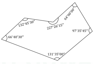
The calculated value of interior angle D is _____° (Answer in decimal degrees and rounded off to two decimal values). The angular misclosure of the closed-loop traverse shown in the figure is _____________ ° (Answer in decimal degrees and rounded off to three decimal places)
- If the departure and latitude of a line are 70 m and -130 m, respectively, then the whole circle bearing of the line in degrees is
While carrying out a traverse survey ABCDA' using a theodolite with the originating station A, the departures and latitudes of the lines, as obtained, are shown in the following figure (not drawn to scale). It is seen that, due to the observational errors, the originating station A and its computed station A' are not the same. For this survey, the 'closing error' in m is
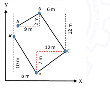
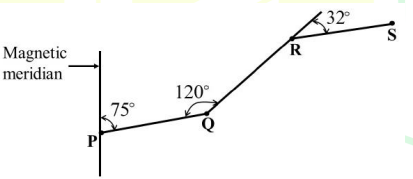
Figure below shows an open traverse PQRS, where P is the starting point of traverse and S is the end point of traverse. Which one of the following is correct?