
Map Scale Area Calculation
This solution details the calculation of the actual site area in hectares, given its measurement on a map and the map's scale.
Understanding the Map Scale
The provided map scale is 1:16000. This ratio indicates that one unit of distance on the map corresponds to 16000 units of the same distance in reality.
- Map Scale: $1 \text{ : } 16000$
- Length Scale Factor: $16000$
Area Calculation Steps
To find the actual area, the length scale factor must be squared because area is a two-dimensional measurement.
-
Calculate the Area Scale Factor:
The area scale factor is the square of the length scale factor.
Area Scale Factor = $(\text{Length Scale Factor})^2 = (16000)^2 = 256,000,000$.
Therefore, 1 square centimeter (sqcm) on the map represents $256,000,000$ sqcm in the actual area.
-
Calculate Actual Area in Square Centimeters (sqcm):
Multiply the map area by the area scale factor to find the actual area in sqcm.
Actual Area (sqcm) = Map Area $\times$ Area Scale Factor
Actual Area (sqcm) = $75 \text{ sqcm} \times 256,000,000 = 19,200,000,000 \text{ sqcm}$.
-
Convert Actual Area to Square Meters (sqm):
To convert sqcm to sqm, use the conversion factor $1 \text{ sqm} = 10000 \text{ sqcm}$ (since $1 \text{ m} = 100 \text{ cm}$).
Actual Area (sqm) = $\frac{19,200,000,000 \text{ sqcm}}{10000 \text{ sqcm/sqm}} = 1,920,000 \text{ sqm}$.
-
Convert Actual Area to Hectares:
To convert sqm to hectares, use the conversion factor $1 \text{ hectare} = 10000 \text{ sqm}$.
Actual Area (hectares) = $\frac{1,920,000 \text{ sqm}}{10000 \text{ sqm/hectare}} = 192 \text{ hectares}$.
Final Result
The actual area of the site is 192 hectares.
Important Questions from Maps
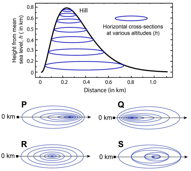
In the given diagram, ovals are marked at different heights ($h$) of a hill. Which one of the following options P, Q, R, and S depicts the top view of the hill?
A contour line joins locations having the same height above the mean sea level. The following is a contour plot of a geographical region. Contour lines are shown at 25 m intervals in this plot.
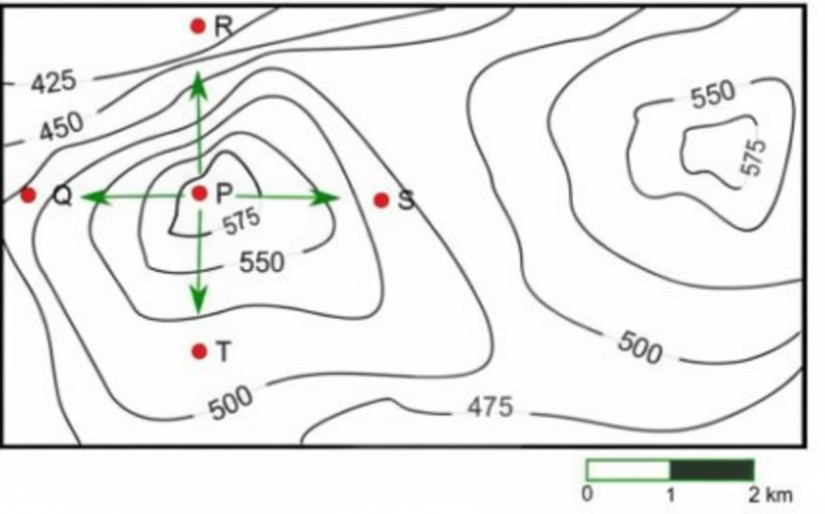
Which of the following is the steepest path leaving from P?


