
Understanding Satellite Imagery Characteristics
Satellite imagery provides a unique perspective of the Earth's surface. When we look at images captured from space, certain features appear very clearly, especially large-scale formations like vast land areas, oceans, or ice fields. The question asks for the specific characteristic of satellite imagery that makes these 'mega patterns' stand out distinctly.
Defining Synoptivity in Remote Sensing
The term that describes the ability of a sensor or system to acquire imagery covering a large geographical area at one time is Synoptivity.
- Synoptivity allows us to see the "big picture" – a wide expanse of the Earth's surface captured in a single image or a set of nearly simultaneous images.
- This comprehensive view is precisely what enables the large-scale mega patterns within landscapes, seascapes, and icescapes to be observed and recognized distinctly.
- Think of it like looking at a map versus looking at a single street; synoptivity provides the map-like view.
Analyzing Other Provided Options
Let's look at why the other options aren't the best fit for this characteristic:
- Large area coverage: While synoptivity results in large area coverage, "large area coverage" itself is more of a description of the *result* rather than the inherent characteristic or capability of simultaneous observation that makes patterns visible. Synoptivity is the specific term for this capability.
- Repetitive coverage: This refers to the ability of a satellite to revisit the same location multiple times over a period. It's about temporal frequency (how often), not spatial extent captured at one moment.
- Amenability: This term generally means suitability or willingness to be easily treated or approached. It has no relevance in the context of satellite image characteristics.
Conclusion on Synoptivity
Therefore, the characteristic of satellite imagery that allows mega patterns within landscapes, seascapes, and icescapes to stand out distinctly, due to the ability to view a large area at once, is correctly identified as Synoptivity.
Important Questions from Miscellaneous
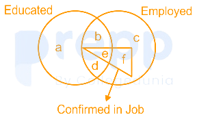
Read the given figure and find the region representing persons who are educated and employed but not confirmed in job.
The magazine in which Mahatma Gandhi mentioned what he wanted the Constitution to do is:
Which gas shields the surface of the earth from ultraviolet radiation from the sun?
Which event is marked as an Intangible Cultural Heritage of Humanity by UNESCO?
Who has been conferred with the rank of the Commander of the Order of the British Empire in 2018?


