
In the T-O maps, introduced during the period of Christian Europe, the stem of the 'T' represented ______.
Understanding T-O Maps from Christian Europe
T-O maps, also known as Isidorian maps, were a type of medieval world map commonly found in European manuscripts from the 8th century onwards. These maps represented the world known to medieval European geographers, heavily influenced by classical knowledge and Christian theology.
The name "T-O map" comes from its distinctive shape. The map depicts the known world as a circular shape, representing the 'O' (Orbis Terrarum, meaning circle of lands). Within this circle, a 'T' shape divides the landmass into three continents.
The 'T' Structure and What it Represents
The 'T' is formed by two lines:
- A horizontal line at the top.
- A vertical line extending downwards from the center of the horizontal line.
These lines represent significant bodies of water that were seen as dividing the continents.
Specifically, in the T-O map structure:
- The vertical stem of the 'T' typically represents the Mediterranean Sea, which separates Europe and Africa.
- The horizontal bar of the 'T' represents two bodies of water: the Nile River and the Don River (also known as the Tanais). These rivers were seen as separating Asia from Europe and Africa. The part west of the vertical stem was usually the Mediterranean Sea separating Europe and Africa, and the part east of the vertical stem could represent the Nile or Don River.
The three sections created by the 'T' inside the 'O' represented the three known continents:
- Asia was typically shown in the large upper section (east).
- Europe was in the lower left section (north-west).
- Africa was in the lower right section (south-west).
Jerusalem was often placed at the center of the map, at the intersection of the 'T'.
Therefore, based on the structure and typical representation of T-O maps from the period of Christian Europe, the vertical stem of the 'T' represented the Mediterranean Sea.
Important Questions from Miscellaneous
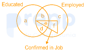
Read the given figure and find the region representing persons who are educated and employed but not confirmed in job.
The magazine in which Mahatma Gandhi mentioned what he wanted the Constitution to do is:
Which gas shields the surface of the earth from ultraviolet radiation from the sun?
Which event is marked as an Intangible Cultural Heritage of Humanity by UNESCO?
Who has been conferred with the rank of the Commander of the Order of the British Empire in 2018?


